File:Gaindakot_Town.jpg
From Wikipedia, the free encyclopedia
No higher resolution available.
Gaindakot_Town.jpg (800 × 600 pixels, file size: 150 KB, MIME type: image/jpeg)
| This is a file from the Wikimedia Commons. Information from its description page there is shown below. Commons is a freely licensed media file repository. You can help. |
Summary
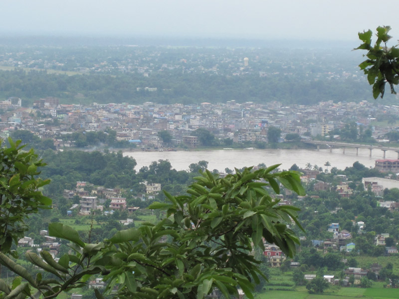
| DescriptionGaindakot Town.jpg |
English: Gaindakot town and Narayanghat (part of Bharatpur city) seen from the Maula Kalika hilltop above Gaindakot, Nepal
Deutsch: Blick vom Maula Kalika-Hügel auf Gaindakot und Narayanghat (Stadtteil von Bharatpur) am gegenüberliegenden Ufer des Narayani (Gandaki), Nepal |
| Date | |
| Source | Own work |
| Author | 南アジア |
| Camera location | 27° 43′ 39.3″ N, 84° 24′ 31.12″ E | View this and other nearby images on: OpenStreetMap |
|---|
Licensing
I, the copyright holder of this work, hereby publish it under the following license:
This file is licensed under the Creative Commons Attribution-Share Alike 3.0 Unported license.
- You are free:
- to share – to copy, distribute and transmit the work
- to remix – to adapt the work
- Under the following conditions:
- attribution – You must give appropriate credit, provide a link to the license, and indicate if changes were made. You may do so in any reasonable manner, but not in any way that suggests the licensor endorses you or your use.
- share alike – If you remix, transform, or build upon the material, you must distribute your contributions under the same or compatible license as the original.
Captions
Add a one-line explanation of what this file represents
Items portrayed in this file
depicts
4 September 2010
27°43'39.299"N, 84°24'31.122"E
File history
Click on a date/time to view the file as it appeared at that time.
| Date/Time | Thumbnail | Dimensions | User | Comment | |
|---|---|---|---|---|---|
| current | 04:05, 22 October 2011 | | 800 × 600 (150 KB) | 南アジア |
File usage
The following pages on the English Wikipedia use this file (pages on other projects are not listed):
Global file usage
The following other wikis use this file:
- Usage on bh.wikipedia.org
- Usage on bn.wikipedia.org
- Usage on ceb.wikipedia.org
- Usage on cs.wikipedia.org
- Usage on de.wikipedia.org
- Usage on eo.wikipedia.org
- Usage on es.wikipedia.org
- Usage on fa.wikipedia.org
- Usage on fi.wikipedia.org
- Usage on hi.wikipedia.org
- Usage on id.wikipedia.org
- Usage on it.wikipedia.org
- Usage on ja.wikipedia.org
- Usage on mai.wikipedia.org
- Usage on ml.wikipedia.org
- Usage on ne.wikipedia.org
- नेपाल
- चितवन जिल्ला
- चुरे
- नेपालको प्रशासनिक विभाजन
- धनगढी उपमहानगरपालिका
- जनकपुरधाम उपमहानगरपालिका
- इटहरी उपमहानगरपालिका
- पोखरा महानगरपालिका
- भरतपुर महानगरपालिका
- घोराही उपमहानगरपालिका
- विकिपीडिया:प्रमुख चित्र/अगस्त २०१४
- ढाँचा:प्रमुख चित्र/अगस्त २०१४
- ढाँचा:नेपालका ठुला सहरहरू
- ढाँचा:प्रमुख चित्र/२०१४-०८-२४
- नेपालका सहरहरूको सूची
- नेपालका नगरपालिकाहरू
- ढाँचा:बागमती प्रदेशका ठूला सहरहरू
- Usage on nl.wikipedia.org
- Usage on pa.wikipedia.org
- Usage on pl.wikivoyage.org
View more global usage of this file.
Metadata
This file contains additional information, probably added from the digital camera or scanner used to create or digitize it.
If the file has been modified from its original state, some details may not fully reflect the modified file.
| Camera manufacturer | Canon |
|---|---|
| Camera model | Canon IXY DIGITAL 210 IS |
| Exposure time | 1/200 sec (0.005) |
| F-number | f/5.8 |
| ISO speed rating | 100 |
| Date and time of data generation | 10:30, 4 September 2010 |
| Lens focal length | 17.9 mm |
| Orientation | Normal |
| Horizontal resolution | 180 dpi |
| Vertical resolution | 180 dpi |
| Software used | Adobe Photoshop 7.0 |
| File change date and time | 16:30, 6 September 2010 |
| Y and C positioning | Co-sited |
| Exif version | 2.21 |
| Date and time of digitizing | 10:30, 4 September 2010 |
| Meaning of each component |
|
| Image compression mode | 3 |
| Shutter speed | 7.65625 |
| APEX aperture | 5.0625 |
| Exposure bias | 0 |
| Maximum land aperture | 5.0625 APEX (f/5.78) |
| Metering mode | Pattern |
| Flash | Flash did not fire, auto mode |
| Supported Flashpix version | 1 |
| Color space | sRGB |
| Focal plane X resolution | 32,018.442622951 |
| Focal plane Y resolution | 32,018.442622951 |
| Focal plane resolution unit | inches |
| Sensing method | One-chip color area sensor |
| File source | Digital still camera |
| Custom image processing | Normal process |
| Exposure mode | Auto exposure |
| White balance | Auto white balance |
| Digital zoom ratio | 1.953125 |
| Scene capture type | Standard |
| IIM version | 2 |
Retrieved from "https://en.wikipedia.org/wiki/File:Gaindakot_Town.jpg"