Mynd:League_of_Nations_Anachronous_Map.PNG
From Wikipedia, the free encyclopedia
Upphafleg skrá (1.357 × 863 mynddílar, skráarstærð: 39 KB, MIME-gerð: image/png)
Skrá þessi er af Wikimedia Commons, og deilt meðal annarra verkefna og nýtist því þar. Hér fyrir neðan er afrit af skráarsíðunni þar.

|
This organization map image could be re-created using vector graphics as an SVG file. This has several advantages; see Commons:Media for cleanup for more information. If an SVG form of this image is available, please upload it and afterwards replace this template with
{{vector version available|new image name}}.
It is recommended to name the SVG file “League of Nations Anachronous Map.svg”—then the template Vector version available (or Vva) does not need the new image name parameter. |

|
This image (or all images in this category) uses inside labels or attached captions in a specific script or language and should be converted to a language neutral form. This would allow its use in all Wikimedia projects and, more importantly, all Wikimedia languages.
Bahasa Melayu ∙ català ∙ čeština ∙ Deutsch ∙ English ∙ español ∙ français ∙ italiano ∙ magyar ∙ Nederlands ∙ Plattdüütsch ∙ português ∙ sicilianu ∙ slovenčina ∙ suomi ∙ беларуская (тарашкевіца) ∙ македонски ∙ русский ∙ српски / srpski ∙ 한국어 ∙ 日本語 ∙ 中文 ∙ 中文(简体) ∙ فارسی ∙ +/− |
| Datasource (reference to visualized facts) is not provided for the data that is visualized in this self-made work. |
Lýsing
| LýsingLeague of Nations Anachronous Map.PNG |
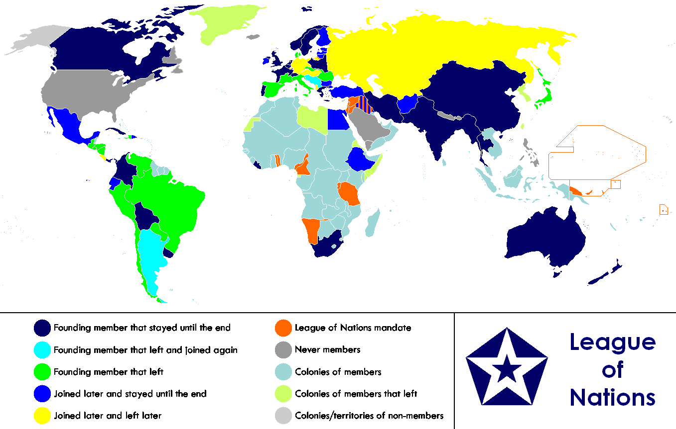
English: Anachronous map of the world between 1920 and 1945 which shows the The League of Nations and the world.
Français : Carte du monde entre 1920 et 1945 montrant la place de la Société des Nations |
| Dagsetning | |
| Uppruni |
This file is lacking source information.
Please edit this file's description and provide a source. |
| Höfundarréttarhafi | Allard Postman, The Netherlands |
| Aðrar útgáfur |
Derivative works of this file: |
Leyfisupplýsingar:
| Þessi skrá er með Creative Commons Tilvísun-DeilaEins 3.0 Óstaðfært notkunarleyfi. Subject to disclaimers. | ||
| ||
| This licensing tag was added to this file as part of the GFDL licensing update.http://creativecommons.org/licenses/by-sa/3.0/CC BY-SA 3.0Creative Commons Attribution-Share Alike 3.0truetrue |

|
Gefið er leyfi til að afrita, dreifa og/eða breyta þessu skjali samkvæmt Frjálsa GNU Free Documentation License, útgáfu 1.2 eða nýrri, sem gefið er út af Frjálsu hugbúnaðarstofnuninni með engum breytingum þar á. Afrit af leyfinu er innifalið í kaflanum GNU Free Documentation License. Subject to disclaimers.http://www.gnu.org/copyleft/fdl.htmlGFDLGNU Free Documentation Licensetruetrue |
Captions
Items portrayed in this file
depicts enska
copyright status enska
copyrighted enska
26. janúar 2007
media type enska
image/png
Breytingaskrá skjals
Smelltu á dagsetningu eða tímasetningu til að sjá hvernig hún leit þá út.
| Dagsetning/Tími | Smámynd | Víddir | Notandi | Athugasemd | |
|---|---|---|---|---|---|
| núverandi | 18. febrúar 2023 kl. 23:02 | | 1.357 × 863 (39 KB) | RickoTroanman22 | Added vertical striped pattern to Jubaland to indicate that it was transferred to Italy. Removed mostly unrecognized nations (Dervish were not recognized by anyone and Tuva and Mongolia were only recognized by the USSR.) |
| 4. nóvember 2021 kl. 05:49 |  | 1.357 × 863 (59 KB) | Randomastwritter | jubaland | |
| 13. júlí 2019 kl. 17:36 |  | 1.357 × 863 (50 KB) | Palaeozoic99 | Change Dominion of Newfoundland; colonial status ceased in 1907. Was never a member. | |
| 29. september 2011 kl. 18:52 |  | 1.357 × 863 (47 KB) | DrKay | Restore Mongolia (which was removed based on a map of 1914 but it was independent from 1921) Swap colors of constant members and new members to match the animation gif | |
| 28. september 2011 kl. 08:01 |  | 1.357 × 863 (46 KB) | DrKay | Put non-members in grey (standard color for non-members of an organization) Put original and constant members in same color as the logo of the organization | |
| 14. janúar 2011 kl. 09:31 |  | 1.357 × 863 (55 KB) | Elmor | minor text corrections | |
| 12. janúar 2011 kl. 08:47 |  | 1.357 × 863 (55 KB) | Elmor | corrected Japan-Soviet border | |
| 9. október 2009 kl. 18:43 |  | 1.357 × 863 (200 KB) | 23prootie~commonswiki | redo | |
| 9. október 2009 kl. 18:42 |  | 1.357 × 863 (200 KB) | 23prootie~commonswiki | redo | |
| 9. október 2009 kl. 18:40 |  | 1.357 × 863 (184 KB) | 23prootie~commonswiki | Reverted to version as of 16:17, 16 March 2009 |
Skráartenglar
Eftirfarandi síða notar þessa skrá:
Altæk notkun skráar
Eftirfarandi wikar nota einnig þessa skrá:
- Notkun á af.wikipedia.org
- Notkun á ast.wikipedia.org
- Notkun á as.wikipedia.org
- Notkun á be.wikipedia.org
- Notkun á bn.wikipedia.org
- Notkun á br.wikipedia.org
- Notkun á cs.wikipedia.org
- Notkun á diq.wikipedia.org
- Notkun á en.wikipedia.org
- Notkun á es.wikipedia.org
- Notkun á eu.wikipedia.org
- Notkun á fa.wikipedia.org
- Notkun á fi.wikipedia.org
- Notkun á fy.wikipedia.org
- Notkun á hr.wikipedia.org
- Notkun á hy.wikipedia.org
- Notkun á io.wikipedia.org
- Notkun á ka.wikipedia.org
- Notkun á ko.wikipedia.org
- Notkun á krc.wikipedia.org
- Notkun á lb.wikipedia.org
- Notkun á li.wikipedia.org
- Notkun á ml.wikipedia.org
- Notkun á my.wikipedia.org
- Notkun á ne.wikipedia.org
- Notkun á nl.wikipedia.org
- Notkun á pa.wikipedia.org
- Notkun á si.wikipedia.org
- Notkun á sk.wikipedia.org
- Notkun á sv.wikipedia.org
- Notkun á ta.wikipedia.org
- Notkun á te.wikipedia.org
- Notkun á th.wikipedia.org
- Notkun á zh.wikipedia.org
Lýsigögn
Þessi skrá inniheldur viðbótarupplýsingar, líklega bætt við úr stafrænu myndavélinni eða skannanum sem notaður var til að búa til eða stafræna hana.
Ef skránni hefur verið breytt frá upprunalegu ástandi gæti verið að sumar upplýsingar endurspegli ekki að fullu breyttu skrána.
| Lárétt upplausn | 37,79 p/sm |
|---|---|
| Lóðrétt upplausn | 37,79 p/sm |