Ofbyld:League_of_Nations_Anachronous_Map.PNG
From Wikipedia, the free encyclopedia
Oarspronklik bestân (1.357 × 863 pixels, bestânsgrutte: 39 KB, MIME-type: image/png)
Dit bestân komt fan Wikimedia Commons, en kin ek troch oare projekten brûkt wurde. De beskriuwing op syn bestânsside dêre wurdt hjirûnder werjûn.

|
This organization map image could be re-created using vector graphics as an SVG file. This has several advantages; see Commons:Media for cleanup for more information. If an SVG form of this image is available, please upload it and afterwards replace this template with
{{vector version available|new image name}}.
It is recommended to name the SVG file “League of Nations Anachronous Map.svg”—then the template Vector version available (or Vva) does not need the new image name parameter. |

|
This image (or all images in this category) uses inside labels or attached captions in a specific script or language and should be converted to a language neutral form. This would allow its use in all Wikimedia projects and, more importantly, all Wikimedia languages.
Bahasa Melayu ∙ català ∙ čeština ∙ Deutsch ∙ English ∙ español ∙ français ∙ italiano ∙ magyar ∙ Nederlands ∙ Plattdüütsch ∙ português ∙ sicilianu ∙ slovenčina ∙ suomi ∙ беларуская (тарашкевіца) ∙ македонски ∙ русский ∙ српски / srpski ∙ 한국어 ∙ 日本語 ∙ 中文 ∙ 中文(简体) ∙ فارسی ∙ +/− |
| Datasource (reference to visualized facts) is not provided for the data that is visualized in this self-made work. |
Gearfetting
| BeskriuwingLeague of Nations Anachronous Map.PNG |
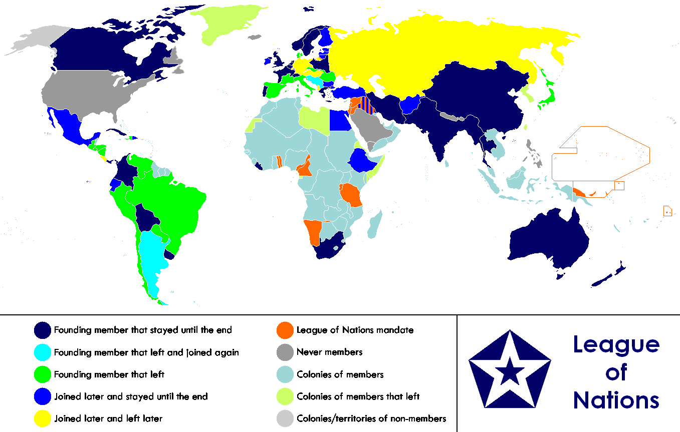
English: Anachronous map of the world between 1920 and 1945 which shows the The League of Nations and the world.
Français : Carte du monde entre 1920 et 1945 montrant la place de la Société des Nations |
| Datum | |
| Boarne |
This file is lacking source information.
Please edit this file's description and provide a source. |
| Auteur | Allard Postman, The Netherlands |
| Oare ferzjes |
Derivative works of this file: |
Lisinsje
| This file is licensed under the Creative Commons Attribution-Share Alike 3.0 Unported license. Subject to disclaimers. | ||
| ||
| This licensing tag was added to this file as part of the GFDL licensing update.http://creativecommons.org/licenses/by-sa/3.0/CC BY-SA 3.0Creative Commons Attribution-Share Alike 3.0truetrue |

|
Der wurdt tastimming jûn ta kopiearjen, fersprieden en/of wizigjen fan dit dokumint ûnder de betinksten fan de GNU-lisinsje foar iepen dokumintaasje, ferzje 1.2, as eltse lettere ferzje útjûn troch de Free Software Foundation; sûnder Ynfariante Seksjes, sûnder Omkaftteksten foar de Foarkante en sûnder Omkaftteksten foar de Efterkante. In kopy fan de lisinsje is opnaam yn de seksje "Text of the GNU Free Documentation License". Subject to disclaimers.http://www.gnu.org/copyleft/fdl.htmlGFDLGNU Free Documentation Licensetruetrue |
Captions
Items portrayed in this file
depicts Ingelsk
copyright status Ingelsk
copyrighted Ingelsk
inception Ingelsk
26 jan 2007
media type Ingelsk
image/png
Triemskiednis
Klik op in datum/tiid om it bestân te besjen sa't it op dat stuit wie.
| Datum/Tiid | Miniatuer | ôfmjittings | Meidogger | Opmerking | |
|---|---|---|---|---|---|
| lêste | 19 feb 2023, 01.02 | | 1.357 × 863 (39 KB) | RickoTroanman22 | Added vertical striped pattern to Jubaland to indicate that it was transferred to Italy. Removed mostly unrecognized nations (Dervish were not recognized by anyone and Tuva and Mongolia were only recognized by the USSR.) |
| 4 nov 2021, 07.49 |  | 1.357 × 863 (59 KB) | Randomastwritter | jubaland | |
| 13 jul 2019, 19.36 |  | 1.357 × 863 (50 KB) | Palaeozoic99 | Change Dominion of Newfoundland; colonial status ceased in 1907. Was never a member. | |
| 29 sep 2011, 20.52 |  | 1.357 × 863 (47 KB) | DrKay | Restore Mongolia (which was removed based on a map of 1914 but it was independent from 1921) Swap colors of constant members and new members to match the animation gif | |
| 28 sep 2011, 10.01 |  | 1.357 × 863 (46 KB) | DrKay | Put non-members in grey (standard color for non-members of an organization) Put original and constant members in same color as the logo of the organization | |
| 14 jan 2011, 11.31 |  | 1.357 × 863 (55 KB) | Elmor | minor text corrections | |
| 12 jan 2011, 10.47 |  | 1.357 × 863 (55 KB) | Elmor | corrected Japan-Soviet border | |
| 9 okt 2009, 20.43 |  | 1.357 × 863 (200 KB) | 23prootie~commonswiki | redo | |
| 9 okt 2009, 20.42 |  | 1.357 × 863 (200 KB) | 23prootie~commonswiki | redo | |
| 9 okt 2009, 20.40 |  | 1.357 × 863 (184 KB) | 23prootie~commonswiki | Reverted to version as of 16:17, 16 March 2009 |
Bestânsgebrûk
De neikommende side brûkt dit bestân:
Globaal bestânsgebrûk
De neikommende oare wiki's brûke dit bestân:
- Gebrûk op af.wikipedia.org
- Gebrûk op ast.wikipedia.org
- Gebrûk op as.wikipedia.org
- Gebrûk op be.wikipedia.org
- Gebrûk op bn.wikipedia.org
- Gebrûk op br.wikipedia.org
- Gebrûk op cs.wikipedia.org
- Gebrûk op diq.wikipedia.org
- Gebrûk op en.wikipedia.org
- Gebrûk op es.wikipedia.org
- Gebrûk op eu.wikipedia.org
- Gebrûk op fa.wikipedia.org
- Gebrûk op fi.wikipedia.org
- Gebrûk op hr.wikipedia.org
- Gebrûk op hy.wikipedia.org
- Gebrûk op io.wikipedia.org
- Gebrûk op is.wikipedia.org
- Gebrûk op ka.wikipedia.org
- Gebrûk op ko.wikipedia.org
- Gebrûk op krc.wikipedia.org
- Gebrûk op lb.wikipedia.org
- Gebrûk op li.wikipedia.org
- Gebrûk op ml.wikipedia.org
- Gebrûk op my.wikipedia.org
- Gebrûk op ne.wikipedia.org
- Gebrûk op nl.wikipedia.org
- Gebrûk op pa.wikipedia.org
- Gebrûk op si.wikipedia.org
- Gebrûk op sk.wikipedia.org
- Gebrûk op sv.wikipedia.org
- Gebrûk op ta.wikipedia.org
- Gebrûk op te.wikipedia.org
- Gebrûk op th.wikipedia.org
- Gebrûk op zh.wikipedia.org
Metadata
Dit bestân befettet oanfoljende ynformaasje, dy't troch in fotokamera, scanner of fotobewurkingsprogramma tafoege wêze kin. As it bestân oanpast is, komme de details mûglik net folslein oerien mei de feroare ôfbylding.
| Horizontale resolúsje | 37,79 dpc |
|---|---|
| Fertikale resolúsje | 37,79 dpc |