File:Roanoke_map_1584.JPG
From Wikipedia, the free encyclopedia
Size of this preview: 293 × 598 pixels. Other resolutions: 117 × 240 pixels | 235 × 480 pixels | 648 × 1,323 pixels.
Original file (648 × 1,323 pixels, file size: 466 KB, MIME type: image/jpeg)
| This is a file from the Wikimedia Commons. Information from its description page there is shown below. Commons is a freely licensed media file repository. You can help. |
Summary
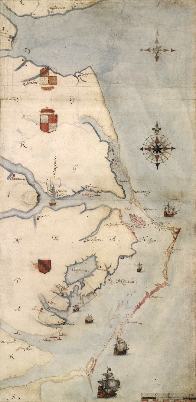
| DescriptionRoanoke map 1584.JPG |
1585 map of the east coast of North America from the Chesapeake Bay to Cape Lookout by John White. Nederlands: Een kaart van het Roanoke-gebied, door John White |
|||||||||||||||||||||||
| Date |
between 1585 and 1593 date QS:P,+1550-00-00T00:00:00Z/7,P1319,+1585-00-00T00:00:00Z/9,P1326,+1593-00-00T00:00:00Z/9 |
|||||||||||||||||||||||
| Source | A British Museum photograph of the map. [1] | |||||||||||||||||||||||
| Author |
creator QS:P170,Q3182736 |
|||||||||||||||||||||||

| This is a retouched picture, which means that it has been digitally altered from its original version. Modifications: cropped and slight levels adjustment. Modifications made by Earthsound.
|
Licensing
|
This is a faithful photographic reproduction of a two-dimensional, public domain work of art. The work of art itself is in the public domain for the following reason:
The official position taken by the Wikimedia Foundation is that "faithful reproductions of two-dimensional public domain works of art are public domain".
This photographic reproduction is therefore also considered to be in the public domain in the United States. In other jurisdictions, re-use of this content may be restricted; see Reuse of PD-Art photographs for details. | |||||
File history
Click on a date/time to view the file as it appeared at that time.
| Date/Time | Thumbnail | Dimensions | User | Comment | |
|---|---|---|---|---|---|
| current | 14:08, 10 July 2013 | | 648 × 1,323 (466 KB) | Earthsound | higher resolution version |
| 01:56, 8 October 2009 |  | 373 × 767 (59 KB) | Multixfer | Higher resolution | |
| 17:43, 7 April 2005 |  | 161 × 326 (16 KB) | Ary29 | 1584 map by John White of Chesapeake Bay to Cape Lookout. {{PD}} Source: en:Image:Ronokmap.JPG Category:Maps of the United States |
File usage
The following pages on the English Wikipedia use this file (pages on other projects are not listed):
- 1580s
- 1584
- Core Banks, North Carolina
- John White (colonist and artist)
- List of North Carolina hurricanes (pre-1900)
- Raid on St. Augustine
- Roanoke Colony
- Simon Fernandes
- Thirteen Colonies
- Wikipedia:Top 25 Report/September 11 to 17, 2016
- Wikipedia:Top 25 Report/September 18 to 24, 2016
- Wikipedia:Wikipedia Signpost/2016-09-29/Traffic report
- Wikipedia:Wikipedia Signpost/Single/2016-09-29
- Portal:Tropical cyclones/Featured article/List of North Carolina hurricanes (pre-1900)
Global file usage
The following other wikis use this file:
- Usage on ar.wikipedia.org
- Usage on arz.wikipedia.org
- Usage on az.wikipedia.org
- Usage on be.wikipedia.org
- Usage on bg.wikipedia.org
- Usage on de.wikipedia.org
- Usage on eo.wikipedia.org
- Usage on es.wikipedia.org
- Usage on fi.wikipedia.org
- Usage on fr.wikipedia.org
- Usage on he.wikipedia.org
- Usage on hu.wikipedia.org
- Usage on hy.wikipedia.org
- Usage on is.wikipedia.org
- Usage on it.wikipedia.org
- Usage on ja.wikipedia.org
- Usage on ko.wikipedia.org
- Usage on mk.wikipedia.org
- Usage on ml.wikipedia.org
- Usage on nl.wikipedia.org
- Usage on no.wikipedia.org
- Usage on nrm.wikipedia.org
- Usage on pl.wikipedia.org
- Usage on pt.wikipedia.org
- Usage on ro.wikipedia.org
- Usage on ru.wikipedia.org
- Usage on sr.wikipedia.org
- Usage on sv.wikipedia.org
- Usage on uk.wikipedia.org
- Usage on ur.wikipedia.org
- Usage on vi.wikipedia.org
- Usage on www.wikidata.org
Metadata
This file contains additional information, probably added from the digital camera or scanner used to create or digitize it.
If the file has been modified from its original state, some details may not fully reflect the modified file.
| Horizontal resolution | 96 dpi |
|---|---|
| Vertical resolution | 96 dpi |
| Software used | Paint.NET v3.5.10 |
Retrieved from "https://en.wikipedia.org/wiki/File:Roanoke_map_1584.JPG"