File:PeelMap.png
From Wikipedia, the free encyclopedia
Size of this preview: 250 × 599 pixels. Other resolutions: 100 × 240 pixels | 200 × 480 pixels.
Original file (800 × 1,918 pixels, file size: 123 KB, MIME type: image/png)
| This is a file from the Wikimedia Commons. Information from its description page there is shown below. Commons is a freely licensed media file repository. You can help. |
Summary
| DescriptionPeelMap.png |
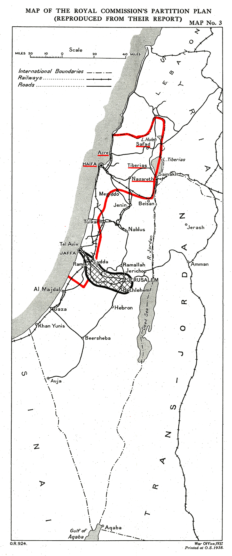
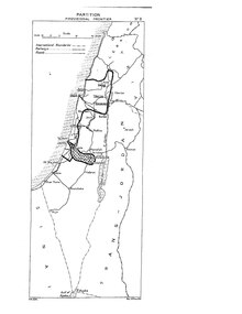
English: Provisional frontiers of the Palestine partition according to the Palestine Royal Commission (Peel report)
العربية: الحدود المؤقتة لتقسيم فلسطين حسب الهيئة الملكية الفلسطينية (تقرير بيل) |
| Date | |
| Source |
 |
| Author | UK Government |
Licensing
| Public domainPublic domainfalsefalse |
This work created by the United Kingdom Government is in the public domain.
This is because it is one of the following:
HMSO has declared that the expiry of Crown Copyrights applies worldwide (ref: HMSO Email Reply) Deutsch ∙ English ∙ Español ∙ français ∙ italiano ∙ Nederlands ∙ polski ∙ português ∙ sicilianu ∙ slovenščina ∙ suomi ∙ Türkçe ∙ македонски ∙ русский ∙ українська ∙ മലയാളം ∙ 한국어 ∙ 日本語 ∙ 简体中文 ∙ 繁體中文 ∙ العربية ∙ +/− |
 |
Captions
Add a one-line explanation of what this file represents
Items portrayed in this file
depicts
27 September 2011
image/png
File history
Click on a date/time to view the file as it appeared at that time.
| Date/Time | Thumbnail | Dimensions | User | Comment | |
|---|---|---|---|---|---|
| current | 14:40, 26 September 2011 | | 800 × 1,918 (123 KB) | Zero0000 |
File usage
The following pages on the English Wikipedia use this file (pages on other projects are not listed):
Global file usage
The following other wikis use this file:
- Usage on ar.wikipedia.org
- Usage on eo.wikipedia.org
- Usage on es.wikipedia.org
- Usage on he.wikipedia.org
- Usage on id.wikipedia.org
- Usage on ml.wikipedia.org
- Usage on nl.wikipedia.org
- Usage on pnb.wikipedia.org
- Usage on pt.wikipedia.org
- Usage on ur.wikipedia.org
- Usage on www.wikidata.org
- Usage on zh.wikipedia.org
Retrieved from "https://en.wikipedia.org/wiki/File:PeelMap.png"