File:Irrawaddyrivermap.jpg
From Wikipedia, the free encyclopedia
Size of this preview: 421 × 599 pixels. Other resolutions: 168 × 240 pixels | 337 × 480 pixels | 862 × 1,227 pixels.
Original file (862 × 1,227 pixels, file size: 208 KB, MIME type: image/jpeg)
| This is a file from the Wikimedia Commons. Information from its description page there is shown below. Commons is a freely licensed media file repository. You can help. |
Summary
| DescriptionIrrawaddyrivermap.jpg |
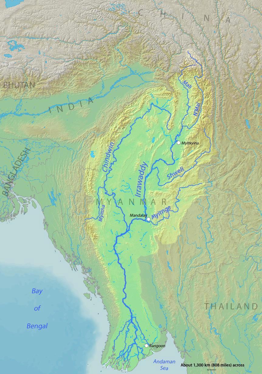
English: Map of the Irrawaddy River, which drains parts of Myanmar (Burma), Thailand and India into the Andaman Sea Français : Carte de l'Irrawaddy. Myitnge |
| Date | |
| Source | Background and river course data from http://www2.demis.nl/mapserver/mapper.asp |
| Author | Shannon |
Licensing
I, the copyright holder of this work, hereby publish it under the following licenses:

|
Permission is granted to copy, distribute and/or modify this document under the terms of the GNU Free Documentation License, Version 1.2 or any later version published by the Free Software Foundation; with no Invariant Sections, no Front-Cover Texts, and no Back-Cover Texts. A copy of the license is included in the section entitled GNU Free Documentation License.http://www.gnu.org/copyleft/fdl.htmlGFDLGNU Free Documentation Licensetruetrue |
This file is licensed under the Creative Commons Attribution-Share Alike Attribution-Share Alike 4.0 International, 3.0 Unported, 2.5 Generic, 2.0 Generic and 1.0 Generic license.
- You are free:
- to share – to copy, distribute and transmit the work
- to remix – to adapt the work
- Under the following conditions:
- attribution – You must give appropriate credit, provide a link to the license, and indicate if changes were made. You may do so in any reasonable manner, but not in any way that suggests the licensor endorses you or your use.
- share alike – If you remix, transform, or build upon the material, you must distribute your contributions under the same or compatible license as the original.
You may select the license of your choice.
Captions
Add a one-line explanation of what this file represents
Items portrayed in this file
depicts
2 March 2010
File history
Click on a date/time to view the file as it appeared at that time.
| Date/Time | Thumbnail | Dimensions | User | Comment | |
|---|---|---|---|---|---|
| current | 00:32, 1 December 2015 | | 862 × 1,227 (208 KB) | Xufanc | Myittha River |
| 08:30, 30 November 2015 |  | 862 × 1,227 (208 KB) | Xufanc | Reverted to version as of 08:22, 30 November 2015 (UTC) | |
| 08:28, 30 November 2015 |  | 862 × 1,227 (208 KB) | Xufanc | Reverted to version as of 08:18, 30 November 2015 (UTC) | |
| 08:25, 30 November 2015 |  | 862 × 1,227 (208 KB) | Xufanc | Reverted to version as of 08:18, 30 November 2015 (UTC) | |
| 08:22, 30 November 2015 |  | 862 × 1,227 (208 KB) | Xufanc | added name of tributary | |
| 08:18, 30 November 2015 |  | 862 × 1,227 (208 KB) | Xufanc | added name of tributary | |
| 06:38, 24 September 2014 |  | 862 × 1,227 (219 KB) | Xufanc | Corrected wrong label | |
| 04:06, 3 March 2010 |  | 862 × 1,227 (653 KB) | Shannon1 | {{Information |Description={{en|1=Map of the Irrawaddy River, which drains parts of Myanmar (Burma), Thailand and India into the Andaman Sea}} |Source=Background and river course data from http://www2.demis.nl/mapserver/mapper.asp |Author=[[User:Shannonc |
File usage
The following pages on the English Wikipedia use this file (pages on other projects are not listed):
Global file usage
The following other wikis use this file:
- Usage on af.wikipedia.org
- Usage on ar.wikipedia.org
- Usage on ast.wikipedia.org
- Usage on azb.wikipedia.org
- Usage on be-tarask.wikipedia.org
- Usage on bg.wikipedia.org
- Usage on bh.wikipedia.org
- Usage on blk.wikipedia.org
- Usage on bn.wikipedia.org
- Usage on br.wikipedia.org
- Usage on ca.wikipedia.org
- Usage on cs.wikipedia.org
- Usage on cy.wikipedia.org
- Usage on de.wikipedia.org
- Usage on en.wikinews.org
- Usage on es.wikipedia.org
- Usage on eu.wikipedia.org
- Usage on fa.wikipedia.org
- Usage on fr.wikipedia.org
- Usage on gl.wikipedia.org
- Usage on hi.wikipedia.org
- Usage on hr.wikipedia.org
- Usage on hu.wikipedia.org
- Usage on hy.wikipedia.org
- Usage on id.wikipedia.org
- Usage on ja.wikipedia.org
- Usage on ka.wikipedia.org
- Usage on ko.wikipedia.org
- Usage on mk.wikipedia.org
- Usage on ml.wikipedia.org
- Usage on my.wikipedia.org
- Usage on pl.wikipedia.org
View more global usage of this file.
Metadata
This file contains additional information, probably added from the digital camera or scanner used to create or digitize it.
If the file has been modified from its original state, some details may not fully reflect the modified file.
| Date and time of data generation | 20:04, 2 March 2010 |
|---|---|
| Orientation | Normal |
| Software used | Adobe Photoshop Elements 6.0 Macintosh |
| File change date and time | 20:04, 2 March 2010 |
| Date and time of digitizing | 20:04, 2 March 2010 |
| DateTimeOriginal subseconds | 00 |
| DateTimeDigitized subseconds | 00 |
| Color space | sRGB |
Retrieved from "https://en.wikipedia.org/wiki/File:Irrawaddyrivermap.jpg"