File:Ghaznavid_Empire_975_-_1187_(AD).PNG
From Wikipedia, the free encyclopedia
No higher resolution available.
Ghaznavid_Empire_975_-_1187_(AD).PNG (620 × 428 pixels, file size: 20 KB, MIME type: image/png)
| This is a file from the Wikimedia Commons. Information from its description page there is shown below. Commons is a freely licensed media file repository. You can help. |
Summary
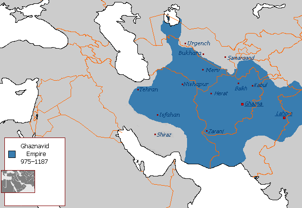
| DescriptionGhaznavid Empire 975 - 1187 (AD).PNG |
Polski: Państwo Ghaznawidów
English: Ghaznavid Empire |
| Date | |
| Source | Own work |
| Author | Arab League |
| Other versions | Arabic |
-ar.PNG)
Licensing
| Public domainPublic domainfalsefalse |
| This work has been released into the public domain by its author, Arab League at English Wikipedia. This applies worldwide. In some countries this may not be legally possible; if so: Arab League grants anyone the right to use this work for any purpose, without any conditions, unless such conditions are required by law.Public domainPublic domainfalsefalse |
Captions
Add a one-line explanation of what this file represents
نقشهٔ قلمروی دودمان غزنویان
Items portrayed in this file
depicts
29 August 2007
File history
Click on a date/time to view the file as it appeared at that time.
| Date/Time | Thumbnail | Dimensions | User | Comment | |
|---|---|---|---|---|---|
| current | 04:54, 7 July 2015 | | 620 × 428 (20 KB) | HistoryofIran | Of course Iranica doesn't, it states which areas they ruled at their extent, stop making reverts without discussing.. |
| 01:05, 4 July 2015 |  | 619 × 428 (21 KB) | Persia10101 | More accurate map after some research | |
| 01:05, 4 July 2015 |  | 619 × 428 (21 KB) | Persia10101 | More accurate map after some research | |
| 00:58, 4 July 2015 |  | 620 × 428 (26 KB) | Persia10101 | Iranica doesnt show a map. reverting to the more commonly agreed map | |
| 00:57, 4 July 2015 |  | 620 × 428 (26 KB) | Persia10101 | Reverted to version as of 08:05, 14 August 2011 | |
| 12:08, 9 May 2014 |  | 620 × 428 (20 KB) | HistoryofIran | Further fixed the map, i will be adding vassals later. | |
| 23:47, 28 January 2014 |  | 620 × 428 (20 KB) | HistoryofIran | Fars and Kerman remained under Buyid rule until the Seljuqs came. | |
| 15:01, 7 June 2013 |  | 620 × 428 (20 KB) | HistoryofIran | Fixed the map, according to Iranica the map was like this at it's greatest extent. | |
| 14:58, 7 June 2013 |  | 620 × 428 (20 KB) | HistoryofIran | Fixed the map, according to Iranica the map was like this at it's greatest extent. | |
| 14:54, 7 June 2013 |  | 620 × 428 (20 KB) | HistoryofIran | Fixed the map, according to Iranica the map was like this at it's greatest extent. |
File usage
The following pages on the English Wikipedia use this file (pages on other projects are not listed):
- Greater Iran
- History of Afghanistan
- Jasrota
- Muslim conquest of Khorasan
- Muslim conquests of Afghanistan
- Nurpur kingdom
- Shia Islam in the Indian subcontinent
- Turkic peoples
- User:Arab Hafez/Map
- User:Kansas Bear/Ghaznavids
- User:Kansas Bear/Saffarid dynasty
- User:Kypioys sx/sandbox
- User:Northamerica1000/Portals of the world
- User:Ottava Rima/Persian Empire
- User:Sobreira/Religion
- Portal:Afghanistan
Global file usage
The following other wikis use this file:
- Usage on arz.wikipedia.org
- Usage on ast.wikipedia.org
- Usage on av.wikipedia.org
- Usage on azb.wikipedia.org
- Usage on az.wikipedia.org
- Usage on ba.wikipedia.org
- Usage on be.wikipedia.org
- Usage on bg.wikipedia.org
- Usage on bn.wikipedia.org
- Usage on ca.wikipedia.org
- Usage on ceb.wikipedia.org
- Usage on ckb.wikipedia.org
- Usage on da.wikipedia.org
- Usage on de.wikipedia.org
- Usage on el.wikipedia.org
- Usage on eo.wikipedia.org
- Usage on es.wikipedia.org
- Usage on et.wikipedia.org
- Usage on eu.wikipedia.org
- Usage on fa.wikipedia.org
View more global usage of this file.
.PNG)
Metadata
This file contains additional information, probably added from the digital camera or scanner used to create or digitize it.
If the file has been modified from its original state, some details may not fully reflect the modified file.
| Horizontal resolution | 28.35 dpc |
|---|---|
| Vertical resolution | 28.35 dpc |
.PNG)