File:1500_map_by_Juan_de_la_Cosa.jpg
From Wikipedia, the free encyclopedia
Size of this preview: 328 × 600 pixels. Other resolutions: 131 × 240 pixels | 262 × 480 pixels | 420 × 768 pixels | 1,163 × 2,127 pixels.
Original file (1,163 × 2,127 pixels, file size: 3.33 MB, MIME type: image/jpeg)
| This is a file from the Wikimedia Commons. Information from its description page there is shown below. Commons is a freely licensed media file repository. You can help. |
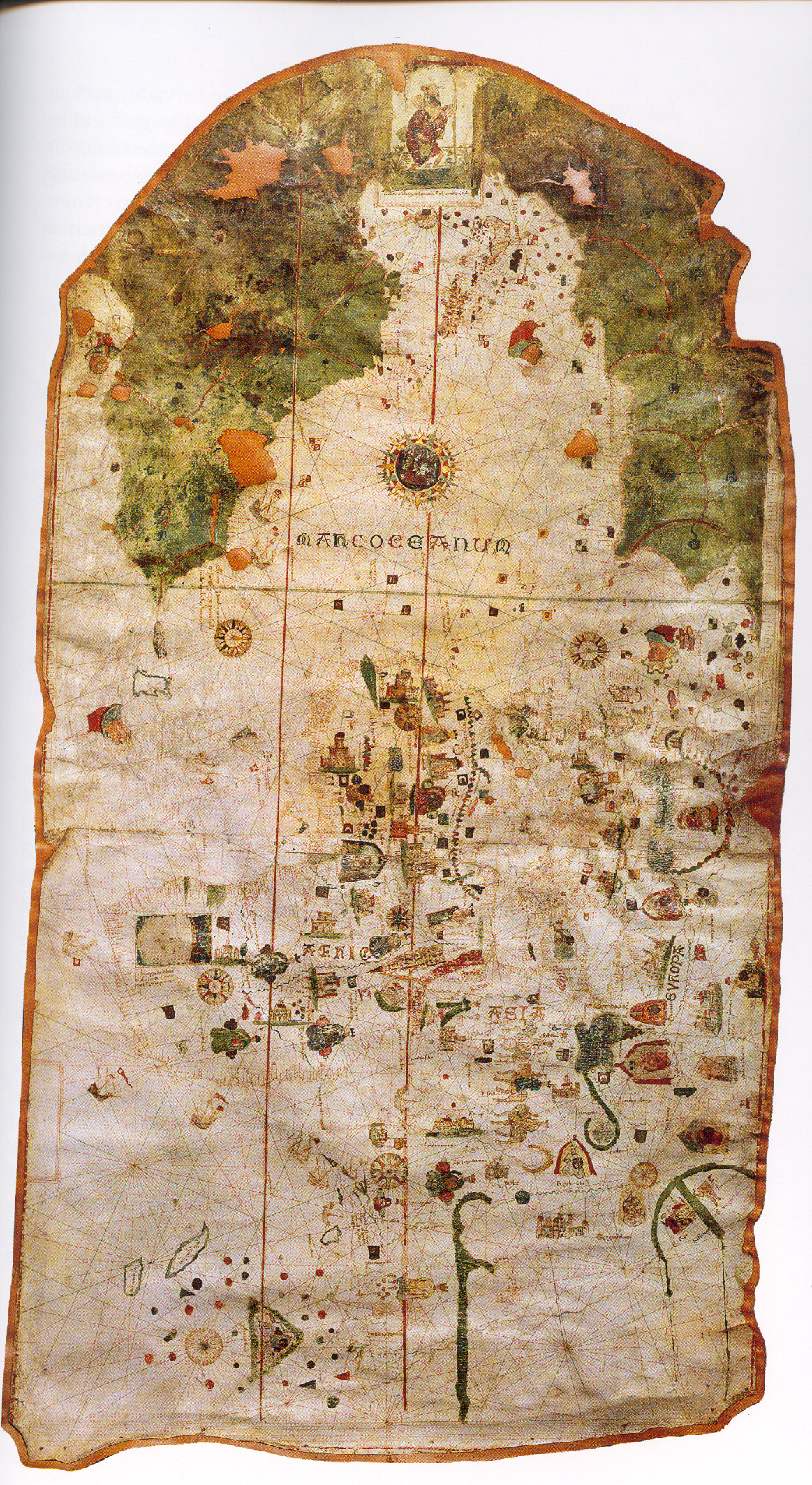
| Juan de la Cosa: English: Called Map of Juan de la Cosa.
Español: Llamado Mapa de Juan de la Cosa. Esperanto: La tiel nomita Mapo de Juan de la Cosa. ( |
|||||||||||||||||||||||||||
|---|---|---|---|---|---|---|---|---|---|---|---|---|---|---|---|---|---|---|---|---|---|---|---|---|---|---|---|
| Artist |
artist QS:P170,Q345620 |
||||||||||||||||||||||||||
| Title |
English: Called Map of Juan de la Cosa.
Español: Llamado Mapa de Juan de la Cosa.
Esperanto: La tiel nomita Mapo de Juan de la Cosa. |
||||||||||||||||||||||||||
| Date |
1500 date QS:P571,+1500-00-00T00:00:00Z/9 |
||||||||||||||||||||||||||
| Medium |
parchment medium QS:P186,Q226697 |
||||||||||||||||||||||||||
| Dimensions |
height: 183 cm (72 in); width: 96 cm (37.7 in) dimensions QS:P2048,183U174728 dimensions QS:P2049,96U174728 |
||||||||||||||||||||||||||
| Collection |
institution QS:P195,Q1815235 |
||||||||||||||||||||||||||
| Current location |
English: Room VIII: Geographical discoveries (from 15th to 18th centuries).
Español: Sala VIII: Descubrimientos geográficos (siglos XV a XVIII). |
||||||||||||||||||||||||||
| Accession number |
257 |
||||||||||||||||||||||||||
| References | Centro Virtual Cervantes | ||||||||||||||||||||||||||
| Source/Photographer | http://tonova.typepad.com/thesuddencurve/historical_blogs/ | ||||||||||||||||||||||||||
| Permission (Reusing this file) |
|
||||||||||||||||||||||||||
| Other versions |
 |
||||||||||||||||||||||||||


Captions
Add a one-line explanation of what this file represents
Items portrayed in this file
depicts
image/jpeg
d97ffb74e726846f0e7564d5ab594545053eebb7
3,493,341 byte
2,127 pixel
1,163 pixel
File history
Click on a date/time to view the file as it appeared at that time.
| Date/Time | Thumbnail | Dimensions | User | Comment | |
|---|---|---|---|---|---|
| current | 04:22, 21 January 2006 | | 1,163 × 2,127 (3.33 MB) | Taichi | Map of w:en:Juan de la Cosa in 1500. Source: http://tonova.typepad.com/thesuddencurve/historical_blogs/ Category:Historical maps |
File usage
The following pages on the English Wikipedia use this file (pages on other projects are not listed):
Global file usage
The following other wikis use this file:
- Usage on ca.wikipedia.org
- Usage on cs.wikipedia.org
- Usage on el.wikipedia.org
- Usage on es.wikipedia.org
- Usage on eu.wikipedia.org
- Usage on fr.wikipedia.org
- Usage on gl.wikipedia.org
- Usage on gn.wikipedia.org
- Usage on he.wikipedia.org
- Usage on id.wikipedia.org
- Usage on it.wikipedia.org
- Usage on ja.wikipedia.org
- Usage on ko.wikipedia.org
- Usage on la.wikipedia.org
- Usage on nn.wikipedia.org
- Usage on pl.wikipedia.org
View more global usage of this file.
Metadata
This file contains additional information, probably added from the digital camera or scanner used to create or digitize it.
If the file has been modified from its original state, some details may not fully reflect the modified file.
| JPEG file comment | LEAD Technologies Inc. V1.01 |
|---|
Retrieved from "https://en.wikipedia.org/wiki/File:1500_map_by_Juan_de_la_Cosa.jpg"