ملف:SevenYearsWar.png
From Wikipedia, the free encyclopedia
حجم البروفه دى: 800 × 370 بكسل. الأبعاد التانيه: 320 × 148 بكسل | 640 × 296 بكسل | 1,357 × 628 بكسل.
الصوره الاصليه (1,357 × 628 بكسل حجم الفايل: 41 كيلوبايت، نوع MIME: image/png)
الملف دا من ويكيميديا كومنز و ممكن تستعمله المشاريع التانيه. الوصف بتاعه صفحة وصف الملف هناك معروض تحت..

|
هذه military map الصورة / الصورتان باستعمال رسومات متجهية ملفات رسوميات شعاعية.
It is recommended to name the SVG file "SevenYearsWar.svg" - then the template Vector version available (or Vva) does not need the new image name parameter.
|
الخلاصة
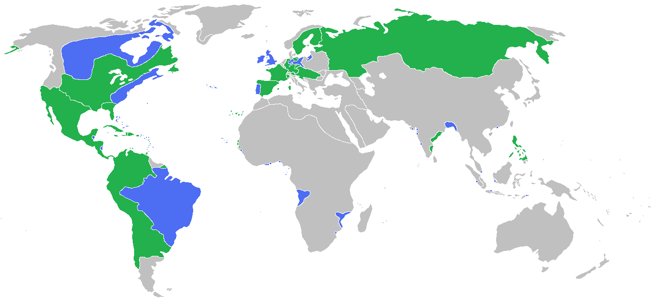
| وصفSevenYearsWar.png |
English: Locator map of the competing sides of the Seven Years War before outset of the war (mid-1750s). Blue: Great Britain, Portugal with more. Green: France, Spain with more. Français : Carte montrant les forces en présence lors de la guerre de Sept Ans (milieu des années 1750).
(Partially based on Atlas of World History (2007) - There was also a treaty in 1783, Imperialism and Revolutions, map) |
| تاريخ | |
| مصدر | عمل شخصى |
| مؤلف | Gabagool |
الترخيص
أنا، صاحب حقوق التأليف والنشر لهذا العمل، أنشر هذا العمل تحت الرخصة التالية:
هذا الملف مُرخص تحت رخصة المشاع المبدع نسبة المصنف إلى مؤلفه 3.0 العامة
- إنت حر:
- فى المشاركه – علشان نسخ و توزيع و بث العمل
- إنك تمزج – فى تكييف العمل
- بالشروط دى:
- نسبه ل – لازم يتنسب العمل للى مألفه بشكل مناسب و توفير رابط للرخصه وتحديد اذا حصلت تغييرات. ممكن ده يتعمل بأى طريقه معقوله، لكن مش بطريقه تشير ان مانح الرخصه بيوافقك على الاستعمال.
الشروحات
أضف شرحاً من سطر واحد لما يُمثِّله هذا الملف
Map of the alliances in the Seven Years' War
Karte der Bündnisse im Siebenjährigen Krieg
قيمة ما بدون عنصر ويكيداتا
مصدر الملف العربية
إنشاء أصيل للرافع العربية
7 يونيه 2009
نوع الوسائط العربية
image/png
تاريخ الفايل
اضغط على الساعه/التاريخ علشان تشوف الفايل زى ما كان فى الوقت ده.
| الساعه / التاريخ | صورة صغيرة | ابعاد | يوزر | تعليق | |
|---|---|---|---|---|---|
| دلوقتي | 15:54، 23 يونيه 2009 | | 1,357 × 628 (41 كيلوبايت) | Gabagool | corrected India more appropriatly |
| 13:59، 11 يونيه 2009 |  | 1,357 × 628 (41 كيلوبايت) | Gabagool | some fixes | |
| 11:16، 11 يونيه 2009 |  | 1,357 × 628 (41 كيلوبايت) | Gabagool | more details in Germany | |
| 22:20، 6 يونيه 2009 |  | 1,357 × 628 (41 كيلوبايت) | Gabagool | {{Information |Description={{en|1=Locator map of the competing sides of the Seven Years War before outset of the war (early 1750s).<br> Blue: Great Britain, Portugal with more. Green: France, Spain with more. Light green: French largest expansion in India |
استخدام الفايل
ال1 صفحة دى فيها وصله للفايل ده:
استخدام الملف العام
الويكيات التانيه دى بتستخدم الفايل ده:
- الاستخدام ف af.wikipedia.org
- الاستخدام ف als.wikipedia.org
- الاستخدام ف an.wikipedia.org
- الاستخدام ف ar.wikipedia.org
- الاستخدام ف ast.wikipedia.org
- الاستخدام ف az.wikipedia.org
- الاستخدام ف ba.wikipedia.org
- الاستخدام ف bg.wikipedia.org
- الاستخدام ف bn.wikipedia.org
- الاستخدام ف br.wikipedia.org
- الاستخدام ف bs.wikipedia.org
- الاستخدام ف ca.wikipedia.org
- الاستخدام ف cs.wikipedia.org
- الاستخدام ف da.wikipedia.org
- الاستخدام ف de.wikipedia.org
- الاستخدام ف dsb.wikipedia.org
- الاستخدام ف en.wikipedia.org
- الاستخدام ف eo.wikipedia.org
- الاستخدام ف es.wikipedia.org
- الاستخدام ف fa.wikipedia.org
- الاستخدام ف fi.wikipedia.org
- الاستخدام ف fr.wikipedia.org
- الاستخدام ف ga.wikipedia.org
- الاستخدام ف he.wikipedia.org
- الاستخدام ف hi.wikipedia.org
- الاستخدام ف hsb.wikipedia.org
- الاستخدام ف is.wikipedia.org
- الاستخدام ف it.wikipedia.org
- الاستخدام ف ja.wikipedia.org
- الاستخدام ف ko.wikipedia.org
اعرض استخدام عام اكتر للملف ده.