Talaksan:East-Hem_1025ad.jpg
From Wikipedia, the free encyclopedia
Buong resolusyon ((3,240 × 1,903 pixel, laki ng talaksan: 3.16 MB, uri ng MIME: image/jpeg))
|
|
Ito ay isang talaksan mula sa Wikimedia Commons. Makikita sa ibaba ang impormasyon mula sa pahina ng paglalarawan nito roon. |

|
This historical map image could be re-created using vector graphics as an SVG file. This has several advantages; see Commons:Media for cleanup for more information. If an SVG form of this image is available, please upload it and afterwards replace this template with
{{vector version available|new image name}}.
It is recommended to name the SVG file “East-Hem 1025ad.svg”—then the template Vector version available (or Vva) does not need the new image name parameter. |
 | This historical map image was uploaded in the JPEG format even though it consists of non-photographic data. This information could be stored more efficiently or accurately in the PNG or SVG format. If possible, please upload a PNG or SVG version of this image without compression artifacts, derived from a non-JPEG source (or with existing artifacts removed). After doing so, please tag the JPEG version with {{Superseded|NewImage.ext}} and remove this tag. This tag should not be applied to photographs or scans. If this image is a diagram or other image suitable for vectorisation, please tag this image with {{Convert to SVG}} instead of {{BadJPEG}}. If not suitable for vectorisation, use {{Convert to PNG}}. For more information, see {{BadJPEG}}. |  |
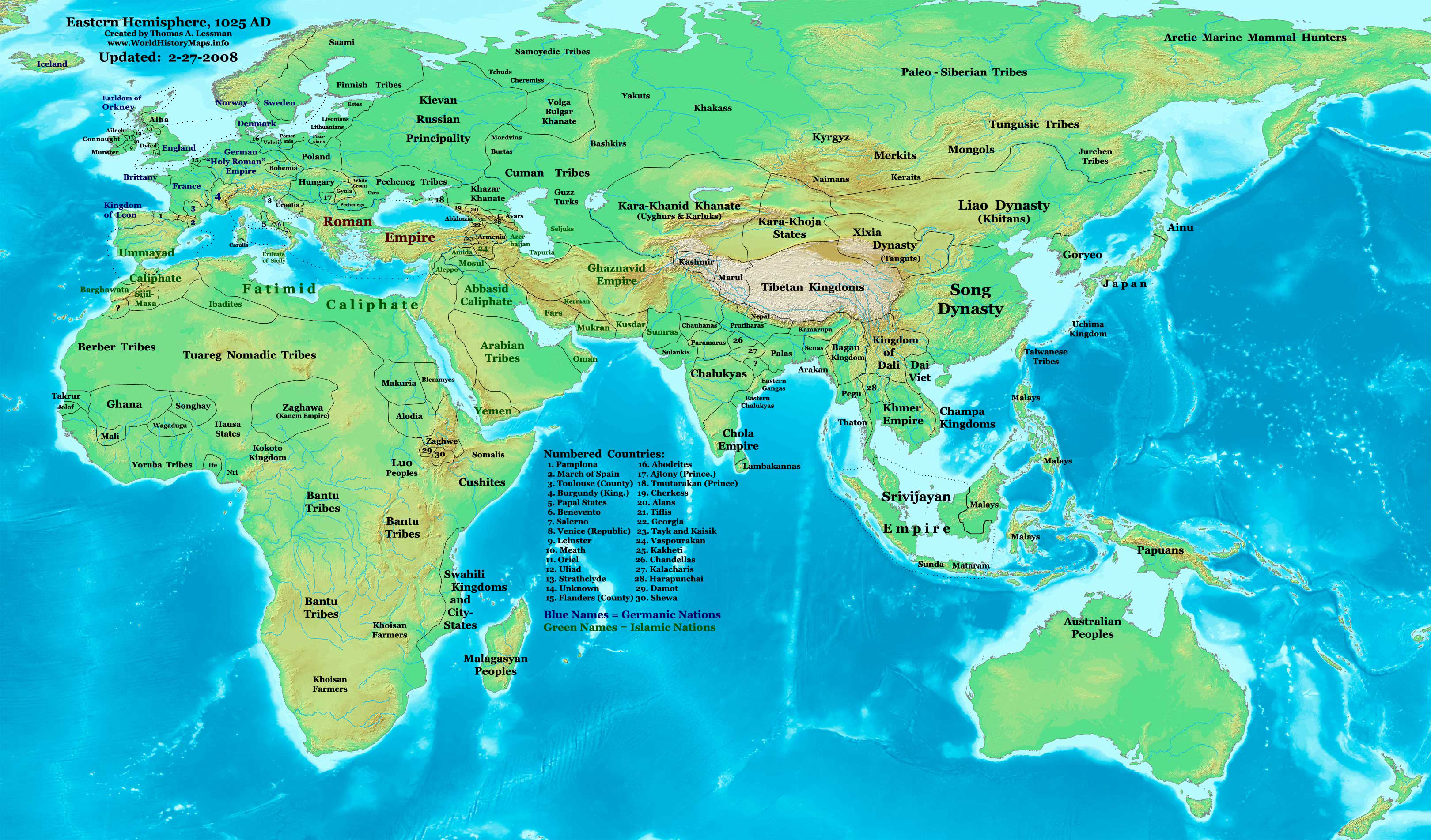
| PaglalarawanEast-Hem 1025ad.jpg | Eastern Hemisphere in 1025 AD. |
| Pinanggalingan | self-made (For reference information, see the Map Source References section below.) |
| May-akda | Thomas Lessman (Contact!) |
| Permiso (Muling paggamit sa file) |
Ako, na may karapatang-ari ng akdang ito, ang naglalathala nito alinsunod sa ilalim ng sumusunod na mga lisensya: Lisensyado ang file na ito sa ilalim ng lisensiyang Creative Commons Attribution-Share Alike 3.0 Unported.
|
| Iba pang mga bersyon | see East-Hem_1025ad.jpg file history on Wikipedia. |
Nilalaman
Map Summary
Original Source URL: http://www.thomaslessman.com/History/images/East-Hem_1025ad.jpg.
This map of the Eastern Hemisphere in 1025 AD was created by Thomas Lessman, based on information from the sources listed below. This map is free for educational use (see Permission info above). When using this map, please mention that it is available for free at www.WorldHistoryMaps.info.
Map Source References
- Remember, sources often conflict with each other. This map is only as accurate as the information that is available to me. To report any errors or to help further this work, please click here, or email Thomas Lessman at talessman@yis.us
References for information contained in this map:
1. Borders of Europe are mostly derived from the www.Euratlas.com map of Europe in 1000 AD.
- (Please note: Bogomolov.PL has done a great job of showing me possible discrepancies in my north European borders compared to this source, due to the differences in the geographical layout of the maps.)
2. Borders of Asian countries derive from various Wikipedia articles and Google history map searches.
3. Fringe areas like Africa, Australia, Siberia, etc. derive from various articles in Wikipedia.
4. Much of the information in this map was cross-checked with Bruce Gordon's Regnal Chronologies.
Other Maps by Thomas Lessman
| Maps of the eastern hemisphere showing history
Bold dates are available on Wikimedia or Wikipedia. | ||
| Primeval | ||
| Ancient
|
·| 600 BC | 550 BC | 527 BC | 500 BC |
400 BC | ·| 1 AD | 50 AD | 100 AD | 200 AD | 300 AD | | |
| Medieval |
·| 500 AD | 565 AD | 600 AD | 700 AD | | |
| Modern |
·| 1500 AD | · * For historical maps of the whole world, | |
| history links talk edit view | ||
Tala ng orihinal na pagkarga
- 2008-01-21 22:17 Talessman 3240×1903×8 (795129 bytes) Corrected borders of Southeast Asia, Africa, Scandinavia, and added more info for East Asia and Africa.
- 2007-12-05 20:33 Talessman 3240×1903×8 (774637 bytes) Corrected borders for Mongolia, added names of smaller countries (with numbered legend), added more info for Africa, corrected information for Indonesia.
- 2007-11-09 15:14 Talessman 3240×1903×8 (727501 bytes) Corrected borders of Srivijaya, Sudan, and Ethiopia, also added info on other African tribes and nations, also added info for far eastern islands.
- 2007-09-26 16:26 Talessman 2880×1692×8 (571380 bytes) Author: Thomas A. Lessman. Source URL: http://www.ThomasLessman.com/History/images/East-Hem_1025ad.jpg. Image was created by me (Thomas Lessman) based on historical information located on Wikipedia, as well as information from maps located in Wikipedia an
- 2007-09-12 21:54 Talessman 2880×1692×8 (558662 bytes) Author: Thomas A. Lessman. Source URL: http://www.ThomasLessman.com/History/images/East-Hem_1025ad.jpg. Image was created by me (Thomas Lessman) based on historical information located on Wikipedia, as well as information from maps located in Wikipedia an
Captions
Items portrayed in this file
depicts English
creator English
some value
copyright status English
copyrighted English
Nakaraan ng file
Pindutin ang araw/oras upang makita kung papaano ang itsura ng talaksan noong oras na iyon.
| Araw/Oras | Thumbnail | Mga dimensiyon | tagagamit | Kumento | |
|---|---|---|---|---|---|
| ngayon | 11:09, 16 Enero 2009 | | 3,240 × 1,903 (3.16 MB) | Ukabia | {{Information |Description= |Source= |Date= |Author= |Permission= |other_versions= }} |
| 21:27, 9 Mayo 2008 |  | 3,240 × 1,903 (778 KB) | Talessman | {{Information |Description=Eastern Hemisphere in 1025 AD. |Source=self-made |Author=User:Talessman |Permission={{self|cc-by-sa-3.0}} }} |
Mga ugnay
Nakaturo sa talaksan na ito ang mga sumusunod na mga pahina:
Pandaigdigang paggamit sa file
Ginagamit ng mga sumusunod na wiki ang file na ito:
- Paggamit sa ar.wikipedia.org
- Paggamit sa arz.wikipedia.org
- Paggamit sa azb.wikipedia.org
- Paggamit sa be.wikipedia.org
- Paggamit sa bs.wikipedia.org
- Paggamit sa ceb.wikipedia.org
- Paggamit sa de.wikiversity.org
- Paggamit sa en.wikipedia.org
- 11th century
- User:Tompw/sandbox10
- User:Talessman/Maps
- User talk:Talessman/Maps
- User:Benjamin Trovato/sandbox
- List of states during the Middle Ages
- List of political entities in the 11th century
- User:Navops47/sandbox10
- List of countries by population in 1000
- Champa–Đại Cồ Việt war (982)
- User:Falcaorib/Ancient East Hemisphere
- Paggamit sa es.wikipedia.org
- Paggamit sa fa.wikipedia.org
- Paggamit sa fr.wikipedia.org
- Paggamit sa gl.wikipedia.org
- Paggamit sa he.wikipedia.org
- Paggamit sa hu.wikipedia.org
- Paggamit sa io.wikipedia.org
- Paggamit sa lt.wikipedia.org
- Paggamit sa mk.wikipedia.org
- Paggamit sa mr.wikipedia.org
- Paggamit sa my.wikipedia.org
- Paggamit sa pnb.wikipedia.org
- Paggamit sa ps.wikipedia.org
- Paggamit sa ro.wikipedia.org
- Paggamit sa rue.wikipedia.org
- Paggamit sa ru.wikipedia.org
- Paggamit sa shn.wikipedia.org
- Paggamit sa si.wikipedia.org
- Paggamit sa sv.wikipedia.org
- Paggamit sa sw.wikipedia.org
- Paggamit sa tg.wikipedia.org
- Paggamit sa th.wikipedia.org
- Paggamit sa ur.wikipedia.org
Tingnan ang karagdagang pandaigdigang paggamit sa file na ito.
Metadata
Naglalaman ng mga karagdagang impormasyon ang talaksan na ito, marahil nadagdag mula sa kamerang digital o scanner na ginamit upang makalikha o gawing digital ito. Kung nabago ang talaksan mula sa orihinal na katayuan, maaaring hindi maipapakita ng lubusan ang detalye ng binagong larawan.
| Oryentasyon | Karaniwan |
|---|---|
| Pahigang resolusyon | 72 dpi |
| Patayong resolusyon | 72 dpi |
| Ginamit na software | Adobe Photoshop CS3 Macintosh |
| Araw at oras ng pagpapalit ng talaksan | 11:07, 16 Enero 2009 |
| Espasyo ng kulay | Hindi nakaakma sa pamantayang sukat |