Fișier:Great_Salt_Lake_ISS_2003.jpg
From Wikipedia, the free encyclopedia
Mărimea acestei previzualizări: 612 × 600 pixeli. Alte rezoluții: 245 × 240 pixeli | 490 × 480 pixeli | 996 × 976 pixeli.
Mărește rezoluția imaginii (996 × 976 pixeli, mărime fișier: 248 KB, tip MIME: image/jpeg)
| Acest fișier se află la Wikimedia Commons. Consultați pagina sa descriptivă acolo. |
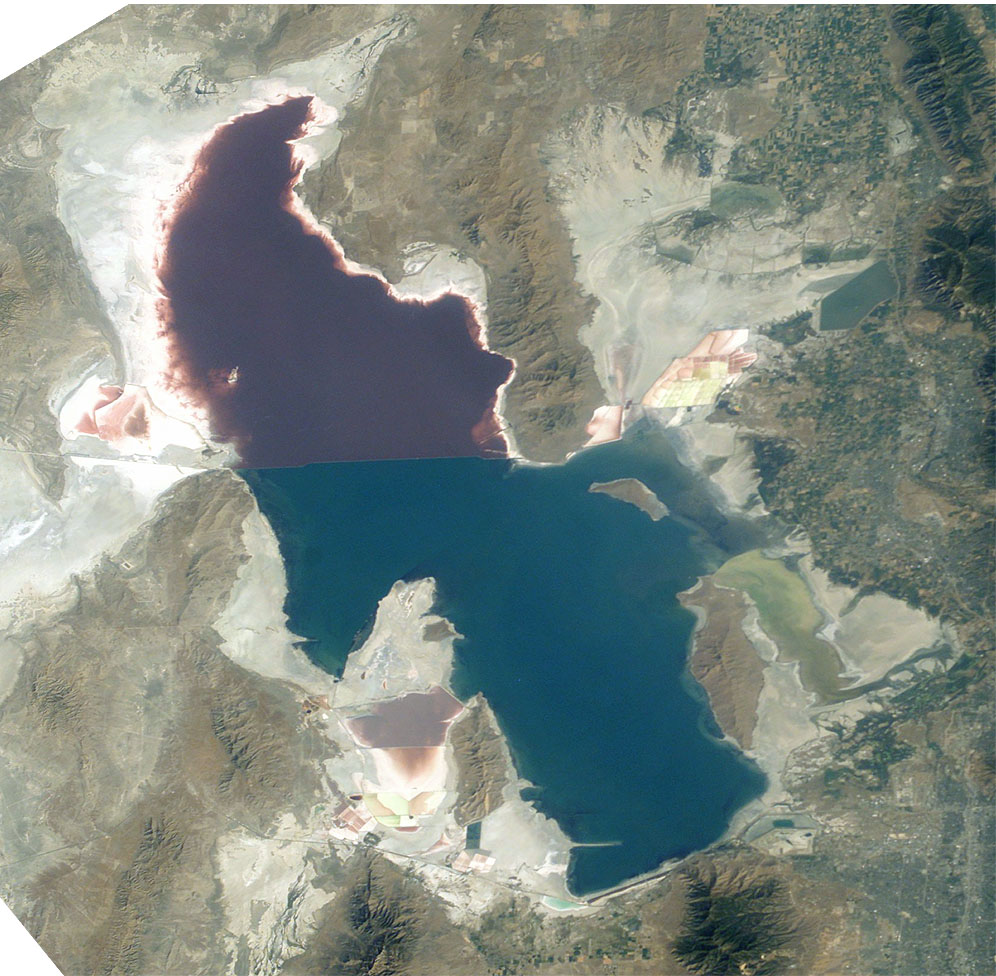
Great Salt Lake from German Wikipedia
- Description:
- Great Salt Lake, Utah, to the right (east) are the Wasatch Mountains, to the lower right is Salt Lake City, Utah. This photo is taken from the International Space Station from approximately 380 km. The railway clearly separates the north and south sections of the lake, which have different salt concentrations due to the barrier. The northern section ( Gunnison Bay) is at least two times more salty than the southern one, and shows a pink or mauve color. The water level of the lake is very low: note that the northeast arm of the lake has disappeared, and that Antelope Island is no longer an island at all.
- Sequence of landforms (west-to-east), north:
en:Curlew Valley, en:Hansel Mountains, Hansel Valley, North Promontory Mountains, en:Blue Creek Valley, Blue Spring Hills, Penrose-Bothwell, Utah - Islands:
en:Stansbury Island, en:Antelope Island, en:Fremont Island-(north) - Sequence, south:
(en:Lakeside Mountains), en:Cedar Mountains (Tooele County), en:Skull Valley (Utah), en:Stansbury Mountains, Tooele Valley, en:Oquirrh Mountains, SLC - West lake: en:Hogup Mountains, (northwest), en:Lakeside Mountains, (southwest)
- Lake center: en:Promontory Mountains
- Sequence of landforms (west-to-east), north:
- Date: 19 August 2003, GMT time: 16:37
- Colors adapted: geographically coded
- Great Salt Lake, Utah, to the right (east) are the Wasatch Mountains, to the lower right is Salt Lake City, Utah. This photo is taken from the International Space Station from approximately 380 km. The railway clearly separates the north and south sections of the lake, which have different salt concentrations due to the barrier. The northern section ( Gunnison Bay) is at least two times more salty than the southern one, and shows a pink or mauve color. The water level of the lake is very low: note that the northeast arm of the lake has disappeared, and that Antelope Island is no longer an island at all.
- Source:
- NASA's Earth Observatory [1]
- License:
| Public domainPublic domainfalsefalse |
| Acest fişier este în domeniul public fiindcă a fost creat de NASA. Politica drepturilor de autor a NASA spune că „Materialul NASA nu este protejat de dreptul de autor atâta timp cât nu se precizează altfel”. (NASA copyright policy page sau JPL Image Use Policy). | ||
 |
Atenţie:
|
From : http://en.wikipedia.org/wiki/Image:Great_Salt_Lake_ISS_2003.JPG
| Annotations InfoField | This image is annotated: View the annotations at Commons |
221
442
312
42
996
976
Lucin Cutoff
666
556
125
213
996
976
Antelope Island State Park
Captions
Add a one-line explanation of what this file represents
The Great Salt Lake (an endorheic lake) in Utah, taken from the International space station.
Большое Солёное Озеро , США, фото с МКС
Items portrayed in this file
subiectul reprezentat
Jack Boucher engleză
image/jpeg
Istoricul fișierului
Apăsați pe Data și ora pentru a vedea versiunea trimisă atunci.
| Data și ora | Miniatură | Dimensiuni | Utilizator | Comentariu | |
|---|---|---|---|---|---|
| actuală | 11 noiembrie 2005 12:09 | | 996x976 (248 KB) | Urban~commonswiki | Great Salt Lake from German Wikipedia * Description: ** Great Salt Lake, Utah, to the right (east) are the Wasatch Mountains, to the lower right is Salt Lake City, Utah. This photo is taken from the International Space Station from a |
Utilizarea fișierului
Următoarele pagini conțin această imagine:
Utilizarea globală a fișierului
Următoarele alte proiecte wiki folosesc acest fișier:
- Utilizare la ar.wikipedia.org
- Utilizare la arz.wikipedia.org
- Utilizare la az.wikipedia.org
- Utilizare la be.wikipedia.org
- Utilizare la bn.wikipedia.org
- Utilizare la br.wikipedia.org
- Utilizare la ceb.wikipedia.org
- Utilizare la cv.wikipedia.org
- Utilizare la da.wikipedia.org
- Utilizare la de.wikipedia.org
- Utilizare la el.wikipedia.org
- Utilizare la en.wikipedia.org
- Jim Bridger
- Endorheic basin
- User:Cool Hand Luke/Photos
- Portal:United States/Selected article/2006, week 37
- Portal:United States/Selected article/2006, week 38
- Portal:United States/Selected article/2006, week 39
- Portal:United States/Selected article/2006, week 40
- Wikipedia:WikiProject Lakes/Galleries/1
- Endorheic lake
- Blue Creek Valley
- Utilizare la eo.wikipedia.org
- Utilizare la es.wikipedia.org
- Utilizare la et.wikipedia.org
- Utilizare la fa.wikipedia.org
- Utilizare la fi.wikipedia.org
- Utilizare la fr.wikipedia.org
- Grand Lac Salé
- Lac Bonneville
- Wikipédia:Lumière sur/Juin 2008
- Wikipédia:Lumière sur/Grand Lac Salé
- Wikipédia:Sélection/Géographie
- Wikipédia:Sélection/Eau
- Portail:Utah
- Wikipédia:Sélection/Utah
- Portail:Information géographique/Sélection
- Wikipédia:Sélection/Lacs et cours d'eau
- Portail:Salt Lake City
- Wikipédia:Sélection/Salt Lake City
- Wikipédia:Sélection/États-Unis/Bons articles/Partie II
- Julie Moschelesová
- Utilizare la he.wikipedia.org
- Utilizare la hi.wikipedia.org
- Utilizare la hu.wikipedia.org
- Utilizare la hy.wikipedia.org
Vizualizați utilizările globale ale acestui fișier.
Informații
Acest fișier conține informații suplimentare, introduse probabil de aparatul fotografic digital sau scannerul care l-a generat. Dacă fișierul a fost modificat între timp, este posibil ca unele detalii să nu mai fie valabile.
| Orientare | Normală |
|---|---|
| Rezoluție orizontală | 300 dpi |
| Rezoluție verticală | 300 dpi |
| Software folosit | Adobe Photoshop 7.0 |
| Data și ora modificării fișierului | 9 ianuarie 2004 11:45 |
| Spațiu de culoare | Necalibrată |