Ficheiro:Dasht-e_Kavir.jpg
De Wikipedia, a enciclopédia encyclopedia
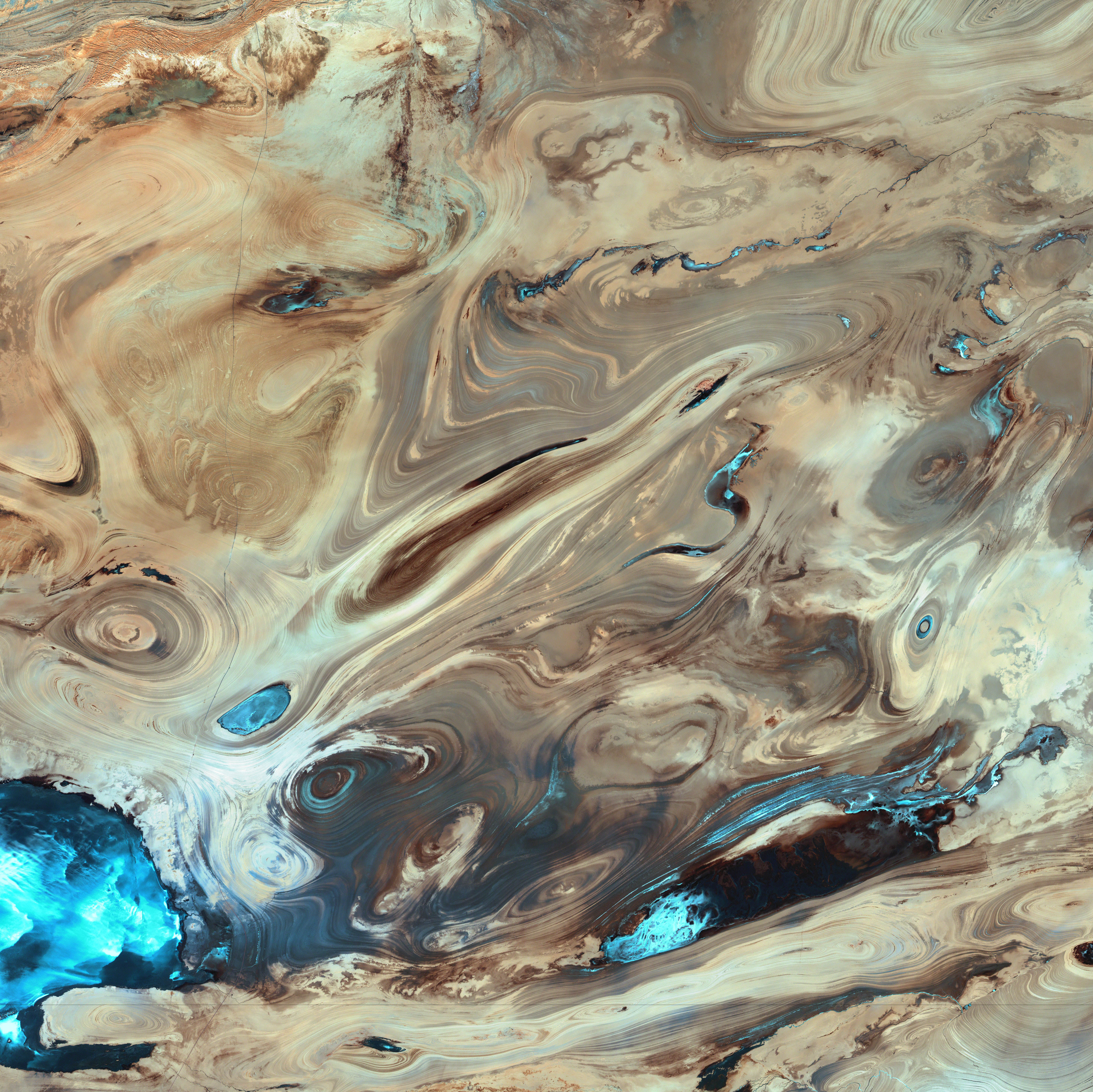
Imagem numa resolução maior (5 822 × 5 820 píxeis, tamanho: 3,5 MB, tipo MIME: image/jpeg)
|
|
Esta imagem provém do Wikimedia Commons, um acervo de conteúdo livre da Wikimedia Foundation que pode ser utilizado por outros projetos.
|
Descrição do ficheiro
| DescriçãoDasht-e Kavir.jpg |
English: A satellite picture of the Dasht-e Kavir desert in Iran.
The patterns you see are formed by different geological layers that have been eroded over thousands of years by wind and sometimes (but not often) rain. The patterns are formed from either horizontal geological layers cut through by topographic changes, or geological formations (folds, domes, etc) in relatively flat terrain. Most of the colours are due to chemical differences in the rocks, whilst the intense blue colours could be due to a range of materials, possibly salt deposits, possibly vegetation, depending on which area of the EM spectrum is represented by blue. I suspect (but don't know, the satellite bands to displayed colours are not mentioned) that the blue colours are salt deposits, but they could equally be other materials too. To be certain, knowledge of the bands to display colours is essential. The black line running horizontally across the image is a sensor drop-out and the data for that line or lines has been irrevocably lost. The linear (but not straight) line running vertically down the middle left is a road. USGS/NASA description: The Dasht-e Kevir, or Great Salt Desert, is the largest desert in Iran. It is primarily uninhabited wasteland, composed of mud and salt marshes covered with crusts of salt that protect the meager moisture from completely evaporating. This image was acquired by Landsat 7’s Enhanced Thematic Mapper plus (ETM+) sensor on October 24, 2000. This is a false-color composite image made using infrared, green, and red wavelengths. The image has also been sharpened using the sensor’s panchromatic band.فارسی: تصویر ماهوارهای از دشت کویر ایران. اکثر رنگهای موجود در نگاره و تفاوتهای شیدهای مختلف، به دلایل اختلافهای ترکیبات شیمیایی مواد تشکیل دهنده صخرهها و تپهها است که در کنار یکدیگر جلوهگر شدهاند. رنگهای تند آبی احتمالاً ناشی از رسوب نمکهای باقی مانده از رستنیها و گیاهان کویری است. البته این استنتاج بستگی مستقیم به طیف الکترومغناطیسی دارد که با رنگ آبی نمایش داده شدهاست. |
| Data | |
| Origem | NASA Earth Observatory. |
| Autor | USGS EROS Data Center Satellite Systems Branch. |
| Localização do objecto | 34° 45′ 18,82″ N, 54° 51′ 45,1″ E | Esta e outras imagens nas suas localizações em: OpenStreetMap |
|---|
(centre of image)
Licenciamento
| Public domainPublic domainfalsefalse |
| Este ficheiro está no domínio público nos Estados Unidos porque foi criado exclusivamente pela NASA. As orientações sobre o direito de autor da NASA são que «as obras da NASA não têm os direitos de autor protegidos salvo indicação em contrário». Veja Template:PD-USGov, as orientações sobre o direito de autor da NASA ou as normas de uso de imagens do Laboratório de Propulsão a Jato (Jet Propulsion Lab, JPL). | ||
 |
Avisos:
|
| Public domainPublic domainfalsefalse |
Esta imagem está no domínio público porque ela contém materiais originalmente provenientes do Serviço Geológico dos Estados Unidos, uma agência do Departamento do Interior dos Estados Unidos. Para mais informações, veja a política oficial da USGS em relação a direitos autorais
Bahasa Indonesia ∙ català ∙ čeština ∙ Deutsch ∙ eesti ∙ English ∙ español ∙ français ∙ galego ∙ italiano ∙ Nederlands ∙ português ∙ polski ∙ sicilianu ∙ suomi ∙ Tiếng Việt ∙ Türkçe ∙ български ∙ македонски ∙ русский ∙ മലയാളം ∙ 한국어 ∙ 日本語 ∙ 中文 ∙ 中文(简体) ∙ 中文(繁體) ∙ العربية ∙ فارسی ∙ +/− |
|
| Anotações InfoField | Esta imagem está anotada: Ver as anotações na wiki Commons |
sensor drop-out
section of road
Legendas
Elementos retratados neste ficheiro
retrata
24 outubro 2000
34°45'18.821"N, 54°51'45.101"E
image/jpeg
Histórico do ficheiro
Clique uma data e hora para ver o ficheiro tal como ele se encontrava nessa altura.
| Data e hora | Miniatura | Dimensões | Utilizador | Comentário | |
|---|---|---|---|---|---|
| atual | 20h39min de 18 de janeiro de 2006 | | 5 822 × 5 820 (3,5 MB) | David.Monniaux | ran it through jpegtran to output optimized, non-progressive jpeg |
| 20h09min de 18 de janeiro de 2006 |  | 5 822 × 5 820 (3,66 MB) | Palladinus | Dasht-e Kavir desert in Iran |
Utilização local do ficheiro
As seguintes 2 páginas usam este ficheiro:
Utilização global do ficheiro
As seguintes wikis usam este ficheiro:
- als.wikipedia.org
- ar.wikipedia.org
- azb.wikipedia.org
- az.wikipedia.org
- be.wikipedia.org
- bg.wikipedia.org
- bs.wikipedia.org
- ca.wikipedia.org
- cs.wikipedia.org
- de.wikipedia.org
- en.wikipedia.org
- es.wikipedia.org
- es.wikibooks.org
- es.wikisource.org
- et.wikipedia.org
- eu.wikipedia.org
- fa.wikipedia.org
- دشت کویر
- ویکیپدیا:انتخاب نگاره هفته/سال ۲۰۱۱/هفته ۱
- ویکیپدیا:انتخاب نگاره هفته/سال ۲۰۱۱/هفته ۱/کویر مرکزی ایران
- ویکیپدیا:نگارههای برگزیده/پدیدههای طبیعی
- ویکیپدیا:نگارههای برگزیده/علمی/زمینشناسی
- ویکیپدیا:گزیدن نگاره برگزیده/فوریه-۲۰۱۲
- ویکیپدیا:نگاره روز/ژوئن ۲۰۱۲
- ویکیپدیا:گزیدن نگاره برگزیده/Dasht-e Kavir.jpg
- الگو:نر/2012-06-21
- الگو:نر محافظت شده/2012-06-21
- بحث کاربر:Alborzagros/بایگانی ۵
- درگاه:علوم زمین/نگاره برگزیده/۲
- درگاه:علوم زمین/نگاره برگزیده
- تصویربرداری ماهوارهای
- fr.wikipedia.org
- gd.wikipedia.org
- gl.wikipedia.org
- hr.wikipedia.org
- id.wikipedia.org
Ver mais utilizações globais deste ficheiro.
Metadados
Este ficheiro contém informação adicional, provavelmente adicionada a partir da câmara digital ou scanner utilizada para criar ou digitalizar a imagem. Caso o ficheiro tenha sido modificado a partir do seu estado original, alguns detalhes poderão não refletir completamente as mudanças efetuadas.
| _error | 0 |
|---|