Attēls:Acprussiamap2.gif
From Wikipedia, the free encyclopedia
Augstāka izšķirtspēja nav pieejama.
Acprussiamap2.gif (510 × 357 pikseļi, faila izmērs: 27 KB, MIME tips: image/gif, 0,1 s)
| Šis fails ir no Vikikrātuves. Tā apraksts no attēla lapas Vikikrātuvē ir parādīts zemāk. Vikikrātuve ir brīvi licencēta failu krātuve. Tu vari tai palīdzēt. |
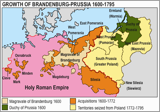
The factual accuracy of this map or the file name is disputed.
Reason: Please see the relevant discussion on the talk page. |  |
This image was copied from wikipedia:pt. The original description was:
Licença GNU, fonte en:Wikipedia.

|
Ir dota atļauja kopēt, izplatīt un/vai pārveidot šo dokumentu saskaņā ar GNU brīvās dokumentācijas licences, versijas 1.2 vai jebkuras vēlākas versijas, ko publiskojis Brīvās programmatūras fonds nosacījumiem; bez nemainīgajām sadaļā, priekšējā un aizmugurēja'vāka tekstiem. Licences kopija ir iekļauta sadaļā ar nosaukumu GNU brīvās dokumentācijas licence.http://www.gnu.org/copyleft/fdl.htmlGFDLGNU Free Documentation Licensetruetrue |
| Šis fails tiek izplatīts saskaņā ar licences Creative Commons Atsauce-Līdzīgi Noteikumi 3.0 Vispārējiem noteikumiem. | ||
| ||
| This licensing tag was added to this file as part of the GFDL licensing update.http://creativecommons.org/licenses/by-sa/3.0/CC BY-SA 3.0Creative Commons Attribution-Share Alike 3.0truetrue |

|
This map has been uploaded by Electionworld from en.wikipedia.org to enable the |
Growth of Prussia en:Image:Ac.prussiamap2.gif

|
This historical map image could be re-created using vector graphics as an SVG file. This has several advantages; see Commons:Media for cleanup for more information. If an SVG form of this image is available, please upload it and afterwards replace this template with
{{vector version available|new image name}}.
It is recommended to name the SVG file “Acprussiamap2.svg”—then the template Vector version available (or Vva) does not need the new image name parameter. |
Captions
Pievieno vienas rindiņas aprakstu, ko šis fails attēlo
Šajā failā attēlotais
attēlo
image/gif
checksum angļu
16c30baaa380e440beb3e17fc730f9e96337f67d
data size angļu
28 096 Baits
0,1 sekunde
357 pikselis
510 pikselis
Faila hronoloģija
Uzklikšķini uz datums/laiks kolonnā esošās saites, lai apskatītos, kā šis fails izskatījās tad.
| Datums/Laiks | Attēls | Izmēri | Dalībnieks | Komentārs | |
|---|---|---|---|---|---|
| tagadējais | 2020. gada 15. marts, plkst. 16.17 | | 510 × 357 (27 KB) | E-960 | Ermland, correction. |
| 2020. gada 15. marts, plkst. 15.50 |  | 510 × 357 (27 KB) | E-960 | Names of territories and format. | |
| 2009. gada 1. jūnijs, plkst. 22.44 |  | 510 × 357 (14 KB) | Hohum | Changed colours to more cartographic, less garish. Made sea blue instead of portions of land. | |
| 2006. gada 25. augusts, plkst. 21.36 |  | 510 × 357 (15 KB) | LeonardoG | This image was copied from wikipedia:pt. The original description was: Licença GNU, fonte en:Wikipedia. {{GFDL}} en:Image:Ac.prussiamap2.gif {| border="1" ! date/time || username || resolution || size || edit summary |---- | |} |
Faila lietojums
Šo failu izmanto šajā 1 lapā:
Globālais faila lietojums
Šīs Vikipēdijas izmanto šo failu:
- Izmantojums af.wikipedia.org
- Izmantojums ar.wikipedia.org
- Izmantojums ast.wikipedia.org
- Izmantojums bg.wikipedia.org
- Izmantojums ca.wikipedia.org
- Izmantojums cs.wikipedia.org
- Izmantojums el.wikipedia.org
- Izmantojums en.wikipedia.org
- History of Germany
- House of Hohenzollern
- Prussia
- Margraviate of Brandenburg
- Prussian Army
- Territorial evolution of Germany
- Subdivisions of the Polish–Lithuanian territories following the partitions
- Prussian Partition
- 18th-century history of Germany
- Brandenburg–Pomeranian conflict
- Treaty of Vossem (1673)
- User:JMvanDijk/Sandbox 9/Box 15/Box 3
- User:Falcaorib/Germany and Prussia
- Izmantojums es.wikipedia.org
- Izmantojums et.wikipedia.org
- Izmantojums eu.wikipedia.org
- Izmantojums fa.wikipedia.org
- Izmantojums fi.wikipedia.org
- Izmantojums fr.wikipedia.org
- Izmantojums he.wikipedia.org
- Izmantojums hy.wikipedia.org
- Izmantojums it.wikipedia.org
Skatīt šī faila pilno globālo izmantojumu.
Saturs iegūts no "https://lv.wikipedia.org/wiki/Attēls:Acprussiamap2.gif"