ფაილი:Colonisation_1800.png
From Wikipedia, the free encyclopedia
თავდაპირველი ფაილი ((1 425 × 625 პიქსელი, ფაილის ზომა: 42 კბ, MIME ტიპი: image/png))
| ეს ფაილი მდებარეობს Wikimedia Commons სერვერზე. იხილეთ მისი აღწერის გვერდი სრული ინფორმაციისთვის. |
 |
გადასვლა ფაილის გვერდზე |
რეზიუმე
| აღწერაColonisation 1800.png |
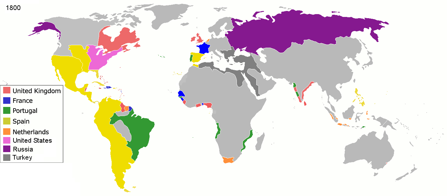
English: Colonial empires in 1800 Français : Empires coloniaux en 1800 Español: Imperios coloniales en 1800 Português: Impérios Coloniais em 1800
|
||||||||||||||||
| თარიღი | |||||||||||||||||
| წყარო | პირადი ნამუშევარი | ||||||||||||||||
| ავტორი | Jluisrs | ||||||||||||||||
| უფლება (ფაილის მეორეული გამოყენება) |
|
||||||||||||||||


.jpg)
._LOC_2001620596.jpg)
| Annotations InfoField | This image is annotated: View the annotations at Commons |
The extent of British influence in New Zealand in 1800 was the existence of whaling ships and flax traders. Americans and French were also present in New Zealand waters. Missionary presence had not even been established yet, and gun traders weren't significant until about the time of the Musket Wars. New Zealand not British prior to 1840 annexation. However, under the 1788 amended charter of the New South Wales colony, islands adjacent to that region of Australia within the bounds of 10°37'S and 43°39'S are included under it. This includes all but the Southern half of South Island. Recognizing this might be like recognizing the Treaty of Tordesillas on this map, but there is some basis for most of New Zealand being counted as a British colony on this map. (See: http://en.wikipedia.org/wiki/History_of_new_zealand#British_sovereignty, http://en.wikipedia.org/wiki/43rd_parallel_south) Nanib (talk) 19:08, 8 September 2011 (UTC)
Araucania and Patagonia not colonized or occupied by Europeans. Mapuche groups prevented Southward expansion by Spanish. Chile and Argentina began occupying the region from 1843-1902. http://en.wikipedia.org/wiki/Patagonia#Chilean_and_Argentine_expansion_.281843-1902.29
A Norwegian colony existed at Nuuk from 1728. It became Danish in 1814. http://en.wikipedia.org/wiki/Nuuk
Omanese colonies on East African coast from 1698. It might be good to include this, but if the focus of this map is European-related colonies, then it shouldn't be. http://en.wikipedia.org/wiki/Oman#Oman_and_East_Africa
British may have had further holdings in Bengal. http://en.wikipedia.org/wiki/Company_rule_in_India#Expansion_and_territory
Zeila, in Western Somililand, ruled by Ottomans from 1548. http://en.wikipedia.org/wiki/History_of_Somaliland#Ottoman_Somaliland
Dutch Gold Coast from 1598. It might be too small to show. http://en.wikipedia.org/wiki/Dutch_Gold_Coast
The Spanish East Indies in the Pacific. After its discovery in 1521, all of Micronesia was included in the Captaincy General of the Philippines of Spain, but his claim effectively began in 1885, the year in which the Micronesia partitioned between Spain and Germany.
In 1800 the French occupation lasted (http://en.wikipedia.org/wiki/French_campaign_in_Egypt_and_Syria)
Captions
Items portrayed in this file
გამოსახული ობიექტი
some value
1 მარტი 2008
source of file ინგლისური
original creation by uploader ინგლისური
media type ინგლისური
image/png
checksum ინგლისური
1c447d15b6569cd35e35abf1b38379514daaa313
data size ინგლისური
42860 ბაიტი
625 pixel
1425 pixel
ფაილის ისტორია
დააწკაპუნეთ თარიღზე/დროზე ფაილის დასათვალიერებლად, როგორც ის მაშინ გამოიყურებოდა.
| თარიღი/დრო | მინიატიურა | ზომები | მომხმარებელი | შენიშვნა | |
|---|---|---|---|---|---|
| მიმდინარე | 19:28, 1 მაისი 2016 | | 1 425×625 (42 კბ) | Mega-light | Dominican Republic was a French colonia between 1795 and 1808 through Treaty of Basilea. |
| 19:21, 1 მაისი 2016 |  | 1 425×625 (42 კბ) | Mega-light | Dominican Republic was a French colonia between 1795 and 1808. | |
| 23:55, 27 სექტემბერი 2014 |  | 1 425×625 (42 კბ) | Leftcry | minor | |
| 05:48, 16 მაისი 2013 |  | 1 425×625 (40 კბ) | Kraj35 | British settlement in Australia - Sydney and Parramatta. | |
| 03:30, 16 იანვარი 2012 |  | 1 425×625 (52 კბ) | Quigley | cleaner legend | |
| 14:07, 29 აპრილი 2010 |  | 1 425×625 (49 კბ) | Kieran4 | Border changes | |
| 14:06, 29 აპრილი 2010 |  | 1 425×625 (49 კბ) | Kieran4 | Dutch claims in Indonesia were exaggerated and Cape Colony was too small. | |
| 14:06, 29 აპრილი 2010 |  | 1 425×625 (49 კბ) | Kieran4 | Dutch claims in Indonesia were exaggerated and Cape Colony was too small. | |
| 16:50, 15 თებერვალი 2009 |  | 1 425×625 (49 კბ) | EuroHistoryTeacher | lousiana was spanish in 1800, would be french officially in 1803 then sold to USA. no spanish settlement in western sahara, or spanish guinea. USA was not a colonisation power. | |
| 20:38, 21 იანვარი 2009 |  | 1 425×625 (49 კბ) | TashkentFox | {{Information |Description= |Source= |Date= |Author= |Permission= |other_versions= }} |
ბმულები
ამ ფაილზე ბმული მოცემულია შემდეგ გვერდებზე:
ფაილის გლობალური გამოყენება
ეს ფაილი გამოიყენება შემდეგ ვიკებში:
- გამოყენება af.wikipedia.org-ში
- გამოყენება ast.wikipedia.org-ში
- გამოყენება av.wikipedia.org-ში
- გამოყენება az.wikipedia.org-ში
- გამოყენება ba.wikipedia.org-ში
- გამოყენება be.wikipedia.org-ში
- გამოყენება ca.wikipedia.org-ში
- გამოყენება ce.wikipedia.org-ში
- გამოყენება cs.wikipedia.org-ში
- გამოყენება da.wikipedia.org-ში
- გამოყენება en.wikipedia.org-ში
- გამოყენება eo.wikipedia.org-ში
- გამოყენება es.wikipedia.org-ში
- გამოყენება eu.wikipedia.org-ში
- გამოყენება fi.wikipedia.org-ში
- გამოყენება fr.wikipedia.org-ში
- გამოყენება gl.wikipedia.org-ში
- გამოყენება ha.wikipedia.org-ში
- გამოყენება he.wikipedia.org-ში
- გამოყენება hy.wikipedia.org-ში
- გამოყენება id.wikipedia.org-ში
- გამოყენება io.wikipedia.org-ში
- გამოყენება it.wikipedia.org-ში
- გამოყენება ja.wikipedia.org-ში
- გამოყენება meta.wikimedia.org-ში
იხილეთ, ამ ფაილის გლობალური გამოყენება.
მეტამონაცემები
ეს ფაილი შეიცავს დამატებით ინფორმაციას, რომელიც სავარაუდოდ ამ სურათის შექმნისას გამოყენებულმა ციფრულმა კამერამ ან სკანერმა დაამატა. თუ ფაილის ორიგინალს სახე ეცვალა, ზოგიერთი დეტალი შესაძლოა მოდიფიცირებულ სურათს არ ეხამებოდეს.
| ჰორიზონტალური გაფართოება | 37,8 dpc |
|---|---|
| ვერტიკალური გაფართოება | 37,8 dpc |