Arkivo:East-Hem_1025ad.jpg
From Wikipedia, the free encyclopedia
Arkivo originala (3 240 × 1 903 pixel-i, grandeso dil arkivo: 3,16 MB, MIME type: image/jpeg)
Ca arkivo jacas en Wikimedia Commons, e povas uzesar en altra projeti. La deskriptado en lua pagino di deskriptado montresas adinfre.

|
Tiu ĉi bildo historical map respektive ĉiuj bildoj en tiu ĉi artikolo aŭ kategorio prefere estu rekreata(j) kiel vektora grafikaĵo en la formato SVG. Vektoraj formatoj por grafikaĵoj havas multajn avantaĝojn, detaloj troveblas anglalingve en la komuneja artikolo Commons:Media for cleanup. Se vi havas aŭ kreas SVG-version de tiu ĉi bildo, bonvolu alŝuti ĝin al la vikipedia komunejo. Post tiu ago, ĉi tiu ŝablono en la bildpaĝo estas anstataŭigenda per la ŝablono {{vector version available|nova dosiera nomo.svg}}.
|
 | This historical map image was uploaded in the JPEG format even though it consists of non-photographic data. This information could be stored more efficiently or accurately in the PNG or SVG format. If possible, please upload a PNG or SVG version of this image without compression artifacts, derived from a non-JPEG source (or with existing artifacts removed). After doing so, please tag the JPEG version with {{Superseded|NewImage.ext}} and remove this tag. This tag should not be applied to photographs or scans. If this image is a diagram or other image suitable for vectorisation, please tag this image with {{Convert to SVG}} instead of {{BadJPEG}}. If not suitable for vectorisation, use {{Convert to PNG}}. For more information, see {{BadJPEG}}. |  |
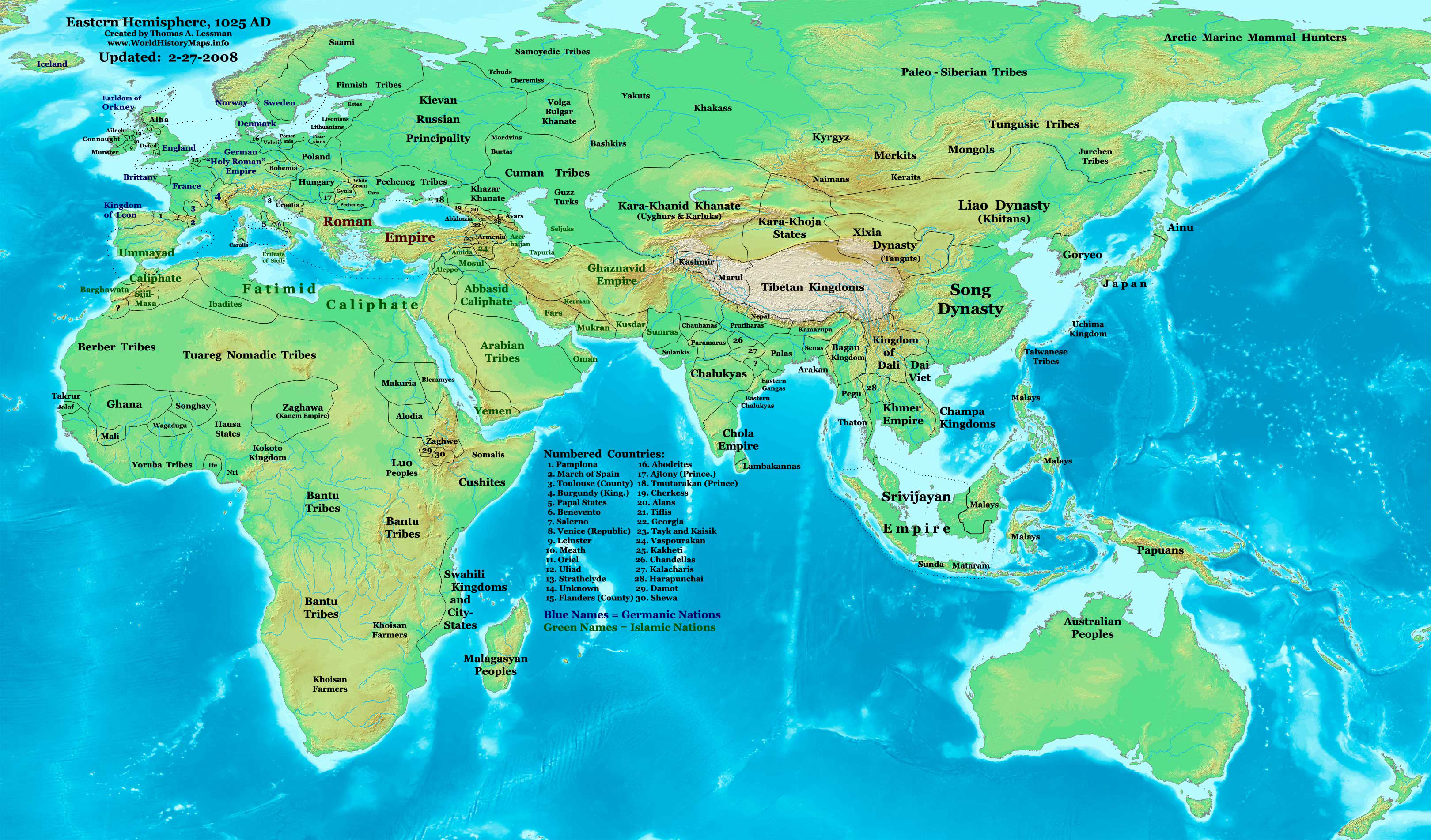
| DeskriptoEast-Hem 1025ad.jpg | Eastern Hemisphere in 1025 AD. |
| Fonto | self-made (For reference information, see the Map Source References section below.) |
| Autoro | Thomas Lessman (Contact!) |
| Yurizo (Riuzo di ica arkivo) |
Me, la posedanto dil autoroyuro pri ica imajo/arkivo, permisos lua uzado camaniere: Ica arkivo liberigesas sub permiso Creative Commons Attribution-Share Alike 3.0 Unported.
|
| Altra versioni | see East-Hem_1025ad.jpg file history on Wikipedia. |
Indexo
Map Summary
Original Source URL: http://www.thomaslessman.com/History/images/East-Hem_1025ad.jpg.
This map of the Eastern Hemisphere in 1025 AD was created by Thomas Lessman, based on information from the sources listed below. This map is free for educational use (see Permission info above). When using this map, please mention that it is available for free at www.WorldHistoryMaps.info.
Map Source References
- Remember, sources often conflict with each other. This map is only as accurate as the information that is available to me. To report any errors or to help further this work, please click here, or email Thomas Lessman at talessman@yis.us
References for information contained in this map:
1. Borders of Europe are mostly derived from the www.Euratlas.com map of Europe in 1000 AD.
- (Please note: Bogomolov.PL has done a great job of showing me possible discrepancies in my north European borders compared to this source, due to the differences in the geographical layout of the maps.)
2. Borders of Asian countries derive from various Wikipedia articles and Google history map searches.
3. Fringe areas like Africa, Australia, Siberia, etc. derive from various articles in Wikipedia.
4. Much of the information in this map was cross-checked with Bruce Gordon's Regnal Chronologies.
Other Maps by Thomas Lessman
| Maps of the eastern hemisphere showing history
Bold dates are available on Wikimedia or Wikipedia. | ||
| Primeval | ||
| Ancient
|
·| 600 BC | 550 BC | 527 BC | 500 BC |
400 BC | ·| 1 AD | 50 AD | 100 AD | 200 AD | 300 AD | | |
| Medieval |
·| 500 AD | 565 AD | 600 AD | 700 AD | | |
| Modern |
·| 1500 AD | · * For historical maps of the whole world, | |
| history links talk edit view | ||
Originala protokolo dum sendado dil arkivo
- 2008-01-21 22:17 Talessman 3240×1903×8 (795129 bytes) Corrected borders of Southeast Asia, Africa, Scandinavia, and added more info for East Asia and Africa.
- 2007-12-05 20:33 Talessman 3240×1903×8 (774637 bytes) Corrected borders for Mongolia, added names of smaller countries (with numbered legend), added more info for Africa, corrected information for Indonesia.
- 2007-11-09 15:14 Talessman 3240×1903×8 (727501 bytes) Corrected borders of Srivijaya, Sudan, and Ethiopia, also added info on other African tribes and nations, also added info for far eastern islands.
- 2007-09-26 16:26 Talessman 2880×1692×8 (571380 bytes) Author: Thomas A. Lessman. Source URL: http://www.ThomasLessman.com/History/images/East-Hem_1025ad.jpg. Image was created by me (Thomas Lessman) based on historical information located on Wikipedia, as well as information from maps located in Wikipedia an
- 2007-09-12 21:54 Talessman 2880×1692×8 (558662 bytes) Author: Thomas A. Lessman. Source URL: http://www.ThomasLessman.com/History/images/East-Hem_1025ad.jpg. Image was created by me (Thomas Lessman) based on historical information located on Wikipedia, as well as information from maps located in Wikipedia an
Titoloj
Kozi montrata en ca arkivo
montras Esperanto
kreinto Esperanto
Iu valoro sen Wikidata ero
stato de kopirajto Esperanto
sub kopirajto Esperanto
permesilo Esperanto
Historio dil arkivo
Kliktez sur la dato/horo por vidar arkivo quale ol aparis ye ta tempo.
| Dato/Horo | Miniaturo | Dimensioni | Uzero | Komento | |
|---|---|---|---|---|---|
| aktuala | 11:09, 16 jan. 2009 | | 3 240 × 1 903 (3,16 MB) | Ukabia | {{Information |Description= |Source= |Date= |Author= |Permission= |other_versions= }} |
| 21:27, 9 may. 2008 |  | 3 240 × 1 903 (778 KB) | Talessman | {{Information |Description=Eastern Hemisphere in 1025 AD. |Source=self-made |Author=User:Talessman |Permission={{self|cc-by-sa-3.0}} }} |
Ligilo al imajo
Ca pagini ligas al imajo:
Uzado en altra Wiki
La sequanta Wiki anke uzas ica arkivo:
- Uzado en ar.wikipedia.org
- Uzado en arz.wikipedia.org
- Uzado en azb.wikipedia.org
- Uzado en be.wikipedia.org
- Uzado en bs.wikipedia.org
- Uzado en ceb.wikipedia.org
- Uzado en de.wikiversity.org
- Uzado en en.wikipedia.org
- 11th century
- User:Tompw/sandbox10
- User:Talessman/Maps
- User talk:Talessman/Maps
- User:Benjamin Trovato/sandbox
- List of states during the Middle Ages
- List of political entities in the 11th century
- User:Navops47/sandbox10
- List of countries by population in 1000
- Champa–Đại Cồ Việt war (982)
- User:Falcaorib/Ancient East Hemisphere
- Uzado en es.wikipedia.org
- Uzado en fa.wikipedia.org
- Uzado en fr.wikipedia.org
- Uzado en gl.wikipedia.org
- Uzado en he.wikipedia.org
- Uzado en hu.wikipedia.org
- Uzado en lt.wikipedia.org
- Uzado en mk.wikipedia.org
- Uzado en mr.wikipedia.org
- Uzado en my.wikipedia.org
- Uzado en pnb.wikipedia.org
- Uzado en ps.wikipedia.org
- Uzado en ro.wikipedia.org
- Uzado en rue.wikipedia.org
- Uzado en ru.wikipedia.org
- Uzado en shn.wikipedia.org
- Uzado en si.wikipedia.org
- Uzado en sv.wikipedia.org
- Uzado en sw.wikipedia.org
- Uzado en tg.wikipedia.org
- Uzado en th.wikipedia.org
- Uzado en tl.wikipedia.org
- Uzado en ur.wikipedia.org
Videz altra uzadi por ica artiklo.
Metadonaji
Ca arkivo kontenas plusa informo, probable furnisita per la kamero elektronikala o per la "scanner" uzata por krear o kopiar l'imajo.
Se l'arkivo modifikesos de lua originala stando, kelka detali povos ne reprezentar exakte l'arkivo modifikata.
| Orientizo | Normala |
|---|---|
| Horizontala distingivo | 72 dpi |
| Vertikala distingivo | 72 dpi |
| *Komputeroprogramo uzata | Adobe Photoshop CS3 Macintosh |
| Dio e horo di la modifiko dil arkivo | 11:07, 16 jan. 2009 |
| Koloro-spaco | Nekalibrita |