קובץ:Cretaceous_seaway.png
ויקיפדיה האנציקלופדיה encyclopedia
אין גרסה ברזולוציה גבוהה יותר.
Cretaceous_seaway.png (250 × 301 פיקסלים, גודל הקובץ: 111 ק"ב, סוג MIME: image/png)
| זהו קובץ שמקורו במיזם ויקישיתוף. תיאורו בדף תיאור הקובץ המקורי (בעברית) מוצג למטה. |
| This image was uploaded in the PNG image format. However, it contains visible lossy compression artifacts. These artifacts may have come from the JPEG format, from saving a single colorful image as GIF instead of PNG or from saving an animated GIF using the incorrect settings (See also Dither). If possible, please provide a superior version of this file, derived from a non-lossy source (or with artifacts removed). If applicable, please replace all instances of the artifact version throughout Wikimedia projects, tag the old version with one of these templates, and remove this tag. For more information, see Commons:Preparing images for upload and Commons:Media for cleanup.
العربية ∙ Deutsch ∙ English ∙ français ∙ македонски ∙ русский ∙ 日本語 ∙ 中文 ∙ 中文(简体) ∙ 中文(繁體) ∙ +/− |
תקציר
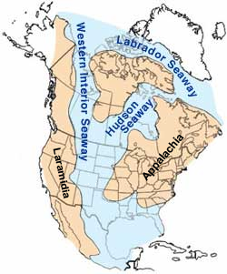
| תיאורCretaceous seaway.png | Map of North America highlighting the shallow inland seaways present during the mid-Cretaceous period. |
| תאריך יצירה | |
| מקור | https://web.archive.org/web/20050115222718/climweb.cr.usgs.gov/research/fossils/ammonites.html |
| יוצר | By William A. Cobban and Kevin C. McKinney, USGS. (Image has been slightly modified by uploader to remove "CO" state designation.) |
| גרסאות אחרות | Arabic, Seaway SVG and Continent labeled SVG |
רישיון
| Public domainPublic domainfalsefalse |
This image is in the public domain in the United States because it only contains materials that originally came from the United States Geological Survey, an agency of the United States Department of the Interior. For more information, see the official USGS copyright policy.
Bahasa Indonesia ∙ català ∙ čeština ∙ Deutsch ∙ eesti ∙ English ∙ español ∙ français ∙ galego ∙ italiano ∙ Nederlands ∙ português ∙ polski ∙ sicilianu ∙ suomi ∙ Tiếng Việt ∙ Türkçe ∙ български ∙ македонски ∙ русский ∙ മലയാളം ∙ 한국어 ∙ 日本語 ∙ 中文 ∙ 中文(简体) ∙ 中文(繁體) ∙ العربية ∙ فارسی ∙ +/− |

.svg)
כיתובים
נא להוסיף משפט שמסביר מה הקובץ מייצג
פריטים שמוצגים בקובץ הזה
מוצג
image/png
113,216 בית
301 פיקסל
250 פיקסל
היסטוריית הקובץ
ניתן ללחוץ על תאריך/שעה כדי לראות את הקובץ כפי שנראה באותו זמן.
| תאריך/שעה | תמונה ממוזערת | ממדים | משתמש | הערה | |
|---|---|---|---|---|---|
| נוכחית | 08:35, 23 באוקטובר 2013 | | 301 × 250 (111 ק"ב) | Kwamikagami | add names of land masses |
| 08:00, 4 במרץ 2005 |  | 301 × 250 (101 ק"ב) | Hadal~commonswiki | from the USGS |
שימוש בקובץ
הדפים הבאים משתמשים בקובץ הזה:
שימוש גלובלי בקובץ
אתרי הוויקי השונים הבאים משתמשים בקובץ זה:
- שימוש באתר ar.wikipedia.org
- שימוש באתר bar.wikipedia.org
- שימוש באתר be-tarask.wikipedia.org
- שימוש באתר bg.wikipedia.org
- שימוש באתר bs.wikipedia.org
- שימוש באתר ca.wikipedia.org
- שימוש באתר cs.wikipedia.org
- שימוש באתר de.wikipedia.org
- שימוש באתר en.wikipedia.org
- שימוש באתר es.wikipedia.org
- שימוש באתר eu.wikipedia.org
- שימוש באתר fa.wikipedia.org
- שימוש באתר fr.wikipedia.org
- שימוש באתר gl.wikipedia.org
- שימוש באתר hu.wikipedia.org
- שימוש באתר id.wikipedia.org
מטא־נתונים
קובץ זה מכיל מידע נוסף, שכנראה הגיע ממצלמה דיגיטלית או מסורק שבהם הקובץ נוצר או עבר דיגיטציה.
אם הקובץ שונה ממצבו הראשוני, כמה מהנתונים להלן עלולים שלא לשקף באופן מלא את הקובץ הנוכחי.
| רזולוציה אופקית | 28.35 dpc |
|---|---|
| רזולוציה אנכית | 28.35 dpc |