Ficheiro:Colonisation_1800.png
From Wikipedia, the free encyclopedia
Ficheiro orixinal (1.425 × 625 píxeles; tamaño do ficheiro: 42 kB; tipo MIME: image/png)
| Este ficheiro procede de Wikimedia Commons. A continuación móstrase a información da súa páxina de descrición. Commons é un repositorio libre de ficheiros multimedia. Pode contribuír alí cargando as súas imaxes. |
Resumo
| DescriciónColonisation 1800.png |
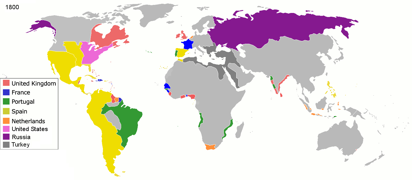
English: Colonial empires in 1800 Français : Empires coloniaux en 1800 Español: Imperios coloniales en 1800 Português: Impérios Coloniais em 1800
|
||||||||||||||||
| Data | |||||||||||||||||
| Orixe | Obra propia | ||||||||||||||||
| Autoría | Jluisrs | ||||||||||||||||
| Licenza (Reuso deste ficheiro) |
|
||||||||||||||||


.jpg)
._LOC_2001620596.jpg)
| Anotacións InfoField | Esta imaxe ten anotacións: Olle as anotacións en Commons |
The extent of British influence in New Zealand in 1800 was the existence of whaling ships and flax traders. Americans and French were also present in New Zealand waters. Missionary presence had not even been established yet, and gun traders weren't significant until about the time of the Musket Wars. New Zealand not British prior to 1840 annexation. However, under the 1788 amended charter of the New South Wales colony, islands adjacent to that region of Australia within the bounds of 10°37'S and 43°39'S are included under it. This includes all but the Southern half of South Island. Recognizing this might be like recognizing the Treaty of Tordesillas on this map, but there is some basis for most of New Zealand being counted as a British colony on this map. (See: http://en.wikipedia.org/wiki/History_of_new_zealand#British_sovereignty, http://en.wikipedia.org/wiki/43rd_parallel_south) Nanib (talk) 19:08, 8 September 2011 (UTC)
Araucania and Patagonia not colonized or occupied by Europeans. Mapuche groups prevented Southward expansion by Spanish. Chile and Argentina began occupying the region from 1843-1902. http://en.wikipedia.org/wiki/Patagonia#Chilean_and_Argentine_expansion_.281843-1902.29
A Norwegian colony existed at Nuuk from 1728. It became Danish in 1814. http://en.wikipedia.org/wiki/Nuuk
Omanese colonies on East African coast from 1698. It might be good to include this, but if the focus of this map is European-related colonies, then it shouldn't be. http://en.wikipedia.org/wiki/Oman#Oman_and_East_Africa
British may have had further holdings in Bengal. http://en.wikipedia.org/wiki/Company_rule_in_India#Expansion_and_territory
Zeila, in Western Somililand, ruled by Ottomans from 1548. http://en.wikipedia.org/wiki/History_of_Somaliland#Ottoman_Somaliland
Dutch Gold Coast from 1598. It might be too small to show. http://en.wikipedia.org/wiki/Dutch_Gold_Coast
The Spanish East Indies in the Pacific. After its discovery in 1521, all of Micronesia was included in the Captaincy General of the Philippines of Spain, but his claim effectively began in 1885, the year in which the Micronesia partitioned between Spain and Germany.
In 1800 the French occupation lasted (http://en.wikipedia.org/wiki/French_campaign_in_Egypt_and_Syria)
Pés de foto
Elementos retratados neste ficheiro
representa a
Um valor sem um elemento no repositório Wikidata
1 marzo 2008
image/png
1c447d15b6569cd35e35abf1b38379514daaa313
tamanho dos dados portugués
42.860 Byte
625 píxel
1.425 píxel
Historial do ficheiro
Prema nunha data/hora para ver o ficheiro tal e como estaba nese momento.
| Data/Hora | Miniatura | Dimensións | Usuario | Comentario | |
|---|---|---|---|---|---|
| actual | 1 de maio de 2016 ás 19:28 | | 1.425 × 625 (42 kB) | Mega-light | Dominican Republic was a French colonia between 1795 and 1808 through Treaty of Basilea. |
| 1 de maio de 2016 ás 19:21 |  | 1.425 × 625 (42 kB) | Mega-light | Dominican Republic was a French colonia between 1795 and 1808. | |
| 27 de setembro de 2014 ás 23:55 |  | 1.425 × 625 (42 kB) | Leftcry | minor | |
| 16 de maio de 2013 ás 05:48 |  | 1.425 × 625 (40 kB) | Kraj35 | British settlement in Australia - Sydney and Parramatta. | |
| 16 de xaneiro de 2012 ás 03:30 |  | 1.425 × 625 (52 kB) | Quigley | cleaner legend | |
| 29 de abril de 2010 ás 14:07 |  | 1.425 × 625 (49 kB) | Kieran4 | Border changes | |
| 29 de abril de 2010 ás 14:06 |  | 1.425 × 625 (49 kB) | Kieran4 | Dutch claims in Indonesia were exaggerated and Cape Colony was too small. | |
| 29 de abril de 2010 ás 14:06 |  | 1.425 × 625 (49 kB) | Kieran4 | Dutch claims in Indonesia were exaggerated and Cape Colony was too small. | |
| 15 de febreiro de 2009 ás 16:50 |  | 1.425 × 625 (49 kB) | EuroHistoryTeacher | lousiana was spanish in 1800, would be french officially in 1803 then sold to USA. no spanish settlement in western sahara, or spanish guinea. USA was not a colonisation power. | |
| 21 de xaneiro de 2009 ás 20:38 |  | 1.425 × 625 (49 kB) | TashkentFox | {{Information |Description= |Source= |Date= |Author= |Permission= |other_versions= }} |
Uso do ficheiro
As seguintes 3 páxinas usan este ficheiro:
Uso global do ficheiro
Os seguintes wikis empregan esta imaxe:
- Uso en af.wikipedia.org
- Uso en ast.wikipedia.org
- Uso en av.wikipedia.org
- Uso en az.wikipedia.org
- Uso en ba.wikipedia.org
- Uso en be.wikipedia.org
- Uso en ca.wikipedia.org
- Uso en ce.wikipedia.org
- Uso en cs.wikipedia.org
- Uso en da.wikipedia.org
- Uso en en.wikipedia.org
- Uso en eo.wikipedia.org
- Uso en es.wikipedia.org
- Uso en eu.wikipedia.org
- Uso en fi.wikipedia.org
- Uso en fr.wikipedia.org
- Uso en ha.wikipedia.org
- Uso en he.wikipedia.org
- Uso en hy.wikipedia.org
- Uso en id.wikipedia.org
- Uso en io.wikipedia.org
- Uso en it.wikipedia.org
- Uso en ja.wikipedia.org
- Uso en ka.wikipedia.org
- Uso en meta.wikimedia.org
- Uso en ml.wikipedia.org
- Uso en nl.wikipedia.org
Ollar o uso global deste ficheiro.
Metadatos
Este ficheiro contén información adicional, probablemente engadida pola cámara dixital ou polo escáner usado para crear ou dixitalizar a imaxe. Se o ficheiro orixinal foi modificado, poida que algúns detalles non se reflictan no ficheiro modificado.
| Resolución horizontal | 37,8 pt/cm |
|---|---|
| Resolución vertical | 37,8 pt/cm |