
Puerto Rico Highway 14
Highway in Puerto Rico / From Wikipedia, the free encyclopedia
Dear Wikiwand AI, let's keep it short by simply answering these key questions:
Can you list the top facts and stats about Puerto Rico Highway 14?
Summarize this article for a 10 year old
SHOW ALL QUESTIONS
Puerto Rico Highway 14 (PR-14) is a main highway connecting Ponce to Cayey, Puerto Rico.[2] The road runs the same course as the historic Carretera Central. The Ponce-to-Coamo section of PR-14 was built under the direction of Spanish engineer Raimundo Camprubí Escudero (b. Pamplona 15 March 1846 – d. Madrid 1924).[3]
 Avenida Tito Castro (PR-14), Barrio Machuelo Abajo, Ponce, looking west (PR-14, near km 4.4)
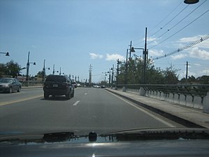 PR-14 westbound at bridge over Río Bucaná on Avenida Tito Castro in Ponce approaching PR-10 (PR-14, near km 5.2)
,_Bo._Machuelo_Abajo,_Ponce,_Puerto_Rico,_mirando_al_oeste_(IMG_3417).jpg)

Quick Facts Route information, Length ...
Highway 14 | ||||
|---|---|---|---|---|
| Ruta 14 | ||||
 | ||||
| Route information | ||||
| Maintained by Puerto Rico DTPW | ||||
| Length | 73.1 km[1] (45.4 mi) | |||
| Existed | 1886 (as the old Carretera Central)–present | |||
| Major junctions | ||||
| West end | ||||
| Major intersections |
| |||
| East end | ||||
| Location | ||||
| Country | United States | |||
| Territory | Puerto Rico | |||
| Municipalities | Ponce, Juana Díaz, Coamo, Aibonito, Cayey | |||
| Highway system | ||||
| ||||
| ||||


Close