Myanmar, officially the Republic of the Union of Myanmar and also known as Burma (the official name until 1989), is a country in Southeast Asia. It is the largest country by area in Mainland Southeast Asia and has a population of about 55 million. It is bordered by Bangladesh and India to its northwest, China to its northeast, Laos and Thailand to its east and southeast, and the Andaman Sea and the Bay of Bengal to its south and southwest. The country's capital city is Naypyidaw, and its largest city is Yangon (formerly Rangoon).
The Early Pagan Kingdom (Burmese: ခေတ်ဦး ပုဂံ ပြည်) was a city-state that existed in the first millennium CE before the emergence of the Pagan Empire in the mid 11th century. The Burmese chronicles state that the "kingdom" was founded in the second century CE. The seat of power of the small kingdom was first located at Arimaddana, Thiri Pyissaya, and Tampawaddy until 849 CE when it was moved to Pagan (Bagan).
Radiocarbon dating shows the earliest human settlement in the Pagan region dates only from the mid-7th century CE. It existed alongside Pyu city-states that dominated Upper Burma. The city-state of Pagan, according to mainstream scholarship, was founded in the mid 9th century by the Mranma of Nanzhao Kingdom. Burmans at Pagan expanded irrigation-based cultivation while borrowing extensively from the Pyus' predominantly Buddhist culture. It was one of many competing city-states in the Pyu realm until the late 10th century when the principality began absorbing its surrounding states. The expansion accelerated in the 1050s and 1060s when King Anawrahta founded the Pagan Empire, the first ever unification of the Irrawaddy valley and its periphery. (Full article...)
Image 3
Major General Aung San as Minister of Defence, 1943 The Burma Independence Army (BIA) was a pro-Japanese and revolutionary army that fought for the end of British rule in Burma by assisting the Japanese in their conquest of the country in 1942 during World War II. It was the first post-colonial army in Burmese history. The BIA was formed from a group known as the Thirty Comrades under the auspices of the Imperial Japanese Army after training the Burmese nationalists in 1941. The BIA's attempts at establishing a government during the invasion led to it being dissolved by the Japanese and the smaller Burma Defence Army (BDA) formed in its place. As Japan guided Burma towards nominal independence, the BDA was expanded into the Burma National Army (BNA) of the State of Burma, a puppet state under Ba Maw, in 1943.
After secret contact with the British during 1944, on 27 March 1945, the BNA revolted against the Japanese. The army received recognition as an ally from Supreme Allied Commander, Lord Mountbatten, who needed their assistance against retreating Japanese forces and to ease the strain between the army's leadership and the British. As part of the Anti-Fascist People's Freedom League, the BNA was re-labelled the Patriotic Burmese Forces (PBF) during a joint Allied–Burmese victory parade in Rangoon on 23 June 1945. Following the war, after tense negotiations, it was decided that the PBF would be integrated into a new Burma Army under British control, but many veterans would continue under old leadership in the paramilitary People's Volunteer Organisation (PVO) in the unstable situation of post-war Burma. (Full article...)
Image 4
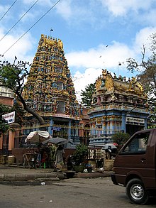
Shri Kali Temple, Burma, a Hindu temple with Dravidian architecture in YangonBurmese Indians are a group of people of Indian origin who live in Myanmar (Burma). The term 'Burmese Indian' refers to a broad range of people from South Asia, most notably from present-day countries such as India and Bangladesh. While Indians have lived in Burma for many centuries, most of the ancestors of the current Burmese Indian community emigrated to Burma from the start of British rule in the mid-19th century to the separation of British Burma from British India in 1937. During colonial times, ethnic Indians formed the backbone of the government and economy serving as soldiers, civil servants, merchants, moneylenders, mobile laborers and dock workers. A series of anti-Indian riots in the 1930s and mass emigration at the onset of the Japanese invasion of Burma in 1942 were followed in the 1960s by the forced migration of hundreds of thousands of ethnic Indians, exacerbated by internal conflict in Myanmar.
Burmese Indians today are estimated to account for approximately 5% (about 2.0–2.5 million people) of the population of Burma and are concentrated largely in the two major cities (Yangon and Mandalay) and former colonial towns (Pyin U Lwin and Kalaw). They wield considerable influence and control over the Burmese economy and have a major socio-cultural presence within the country. Amongst the well-known Burmese Indians is S N Goenka, a leading practitioner and teacher of vipassanā meditation and Helen, a well-known Bollywood film actress who is also of Anglo-Burmese descent. (Full article...)
Image 5
There is a history of persecution of Muslims in Myanmar that continues to the present day. Myanmar is a Buddhist majority country, with significant Christian and Muslim minorities. While Muslims served in the government of Prime Minister U Nu (1948–63), the situation changed with the 1962 Burmese coup d'état. While a few continued to serve, most Christians and Muslims were excluded from positions in the government and army. In 1982, the government introduced regulations that denied citizenship to anyone who could not prove Burmese ancestry from before 1823. This disenfranchised many Muslims in Myanmar, even though they had lived in Myanmar for several generations.
The Rohingya people are a large Muslim group in Myanmar; the Rohingyas have been among the most persecuted group under Myanmar's military regime, with the Kachin, who are predominantly U.S. Baptists, a close second. The UN states that the Rohingyas are one of the most persecuted groups in the world. Since 1948, successive governments have carried out 13 military operations against the Rohingya (including in 1975, 1978, 1989, 1991–92, 2002). During the operations, Myanmar security forces have driven the Rohingyas off their land, burned down their mosques and committed widespread looting, arson and rape of Rohingya Muslims. Outside of these military raids, Rohingya are subjected to frequent theft and extortion from the authorities and many are subjected to forced labor. In some cases, land occupied by Rohingya Muslims has been confiscated and reallocated to local Buddhists. (Full article...)
The Burmese cat (Burmese: ဗမာကြောင်, Băma kyaung, Thai: ทองแดง or ศุภลักษณ์, RTGS:Thongdaeng or Supphalak, meaning copper colour) is a breed of domestic cat, originating in Burma, believed to have its roots near the Thai-Burma border and developed in the United States and Britain.
Most modern Burmese are descendants of one female cat called Wong Mau, which was brought from Burma to the United States in 1930 and bred with American Siamese. From there, American and British breeders developed distinctly different Burmese breed standards, which is unusual among pedigreeddomestic cats. Most modern cat registries do not formally recognise the two as separate breeds, but those that do refer to the British type as the European Burmese. (Full article...)
Image 8
The picture shows the location of Myanmar in Southeast Asia. The geology of Myanmar is shaped by dramatic, ongoing tectonic processes controlled by shifting tectonic components as the Indian plate slides northwards and towards Southeast Asia. Myanmar spans across parts of three tectonic plates (the Indian Plate, Burma microplate and Shan Thai Block) separated by north-trending faults. To the west, a highly obliquesubduction zone separates the offshore Indian plate from the Burma microplate, which underlies most of the country. In the center-east of Myanmar, a right lateral strike slip fault extends from south to north across more than 1,000km (620mi). These tectonic zones are responsible for large earthquakes in the region. The India-Eurasia plate collision which initiated in the Eocene provides the last geological pieces of Myanmar, and thus Myanmar preserves a more extensive Cenozoic geological record as compared to records of the Mesozoic and Paleozoic eras. Myanmar is physiographically divided into three regions: the Indo-Burman Range, Myanmar Central Belt and the Shan Plateau; these all display an arcuate shape bulging westwards. The varying regional tectonic settings of Myanmar not only give rise to disparate regional features, but they also foster the formation of petroleum basins and a diverse mix of mineral resources. (Full article...)
... that the Myanmar Photo Archive(example photograph shown) revealed "a side of modern Myanmar that, until very recently, remained hidden in dusty attics"?
... that the talabaw soup, which consists primarily of bamboo shoots, is the essential dish of Myanmar's Karen people, who use it to supplement rice?
... that clashes between the Myanmar military and local armed groups broke out in Lay Kay Kaw six years after it was established as a "town of peace" between the parties?
Image 10British soldiers remove their shoes at the entrance of Shwedagon Pagoda. To the left, a sign reads "Foot wearing is strictly prohibited" in Burmese, English, Tamil, and Urdu. (from Culture of Myanmar)
Image 18British soldiers dismantling cannons belonging to King Thibaw's forces, Third Anglo-Burmese War, Ava, 27 November 1885. Photographer: Hooper, Willoughby Wallace (1837–1912). (from History of Myanmar)
Image 20The paddle steamer Ramapoora (right) of the British India Steam Navigation Company on the Rangoon river having just arrived from Moulmein. 1895. Photographers: Watts and Skeen (from History of Myanmar)
Image 21Protesters in Yangon carrying signs reading "Free Daw Aung San Suu Kyi" on 8 February 2021. (from History of Myanmar)
Image 23Boxing match, 19th-century watercolour (from Culture of Myanmar)
Image 24Salween river at Mae Sam Laep on the Thai-Myanmar border (from Geography of Myanmar)
Image 25Pagan Kingdom during Narapatisithu's reign. Burmese chronicles also claim Kengtung and Chiang Mai. Core areas shown in darker yellow. Peripheral areas in light yellow. Pagan incorporated key ports of Lower Burma into its core administration by the 13th century. (from History of Myanmar)
Image 27A wedding procession, with the groom and bride dressed in traditional Burmese wedding clothes, reminiscent of royal attire (from Culture of Myanmar)
Image 28The restored Taungoo or Nyaungyan dynasty c. 1650 CE. (from History of Myanmar)
Image 29Political Map of Burma (Myanmar) c. 1450 CE. (from History of Myanmar)
Image 32A group of Buddhist worshipers at Shwedagon Pagoda, an important religious site for Burmese Buddhists (from Culture of Myanmar)
Image 33A bull fight, 19th-century watercolour (from Culture of Myanmar)
Image 34Recorder's Court on Sule Pagoda Road, with the Sule Pagoda at the far end, Rangoon, 1868. Photographer: J. Jackson. (from History of Myanmar)
Image 3519th-century funeral cart and spire, which would form part of the procession from the home to the place of cremation (from Culture of Myanmar)
Image 36Vegetable stall on the roadside at the Madras Lancer Lines, Mandalay, January 1886. Photographer: Hooper, Willoughby Wallace (1837–1912). (from History of Myanmar)
Image 37Two female musicians play the saung at a performance in Mandalay. (from Culture of Myanmar)
Image 38The shores of Irrawaddy River at Nyaung-U, Bagan (from Geography of Myanmar)


![Image 1The Burmese calendar (Burmese: မြန်မာသက္ကရာဇ်, pronounced [mjəmà θɛʔkəɹɪʔ], or ကောဇာသက္ကရာဇ်, [kɔ́zà θɛʔkəɹɪʔ]; Burmese Era (BE) or Myanmar Era (ME)) is a lunisolar calendar in which the months are based on lunar months and years are based on sidereal years. The calendar is largely based on an older version of the Hindu calendar, though unlike the Indian systems, it employs a version of the Metonic cycle. The calendar therefore has to reconcile the sidereal years of the Hindu calendar with the Metonic cycle's near tropical years by adding intercalary months and days at irregular intervals.The calendar has been used continuously in various Burmese states since its purported launch in 640 CE in the Sri Ksetra Kingdom, also called the Pyu era. It was also used as the official calendar in other mainland Southeast Asian kingdoms of Arakan, Lan Na, Xishuangbanna, Lan Xang, Siam, and Cambodia down to the late 19th century. (Full article...)](//upload.wikimedia.org/wikipedia/en/d/d2/Blank.png) Image 1The Burmese calendar (Burmese: မြန်မာသက္ကရာဇ်, pronounced [mjəmà θɛʔkəɹɪʔ], or ကောဇာသက္ကရာဇ်, [kɔ́zà θɛʔkəɹɪʔ]; Burmese Era (BE) or Myanmar Era (ME)) is a lunisolar calendar in which the months are based on lunar months and years are based on sidereal years. The calendar is largely based on an older version of the Hindu calendar, though unlike the Indian systems, it employs a version of the Metonic cycle. The calendar therefore has to reconcile the sidereal years of the Hindu calendar with the Metonic cycle's near tropical years by adding intercalary months and days at irregular intervals.
Image 1The Burmese calendar (Burmese: မြန်မာသက္ကရာဇ်, pronounced [mjəmà θɛʔkəɹɪʔ], or ကောဇာသက္ကရာဇ်, [kɔ́zà θɛʔkəɹɪʔ]; Burmese Era (BE) or Myanmar Era (ME)) is a lunisolar calendar in which the months are based on lunar months and years are based on sidereal years. The calendar is largely based on an older version of the Hindu calendar, though unlike the Indian systems, it employs a version of the Metonic cycle. The calendar therefore has to reconcile the sidereal years of the Hindu calendar with the Metonic cycle's near tropical years by adding intercalary months and days at irregular intervals.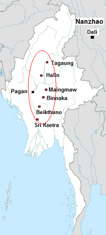

 Brown European male
 Emblem of the Myanmar Air Force
![Image 1The Burmese calendar (Burmese: မြန်မာသက္ကရာဇ်, pronounced [mjəmà θɛʔkəɹɪʔ], or ကောဇာသက္ကရာဇ်, [kɔ́zà θɛʔkəɹɪʔ]; Burmese Era (BE) or Myanmar Era (ME)) is a lunisolar calendar in which the months are based on lunar months and years are based on sidereal years. The calendar is largely based on an older version of the Hindu calendar, though unlike the Indian systems, it employs a version of the Metonic cycle. The calendar therefore has to reconcile the sidereal years of the Hindu calendar with the Metonic cycle's near tropical years by adding intercalary months and days at irregular intervals.The calendar has been used continuously in various Burmese states since its purported launch in 640 CE in the Sri Ksetra Kingdom, also called the Pyu era. It was also used as the official calendar in other mainland Southeast Asian kingdoms of Arakan, Lan Na, Xishuangbanna, Lan Xang, Siam, and Cambodia down to the late 19th century. (Full article...)](./File:Blank.png)


 Image 1A theatrical performance of the Mon dance (from Culture of Myanmar)
 Image 3Portuguese ruler and soldiers mounting an Elephant. Philips, Jan Caspar (draughtsman and engraver) (from History of Myanmar)
 Image 4Saint Mary's Cathedral in Downtown Yangon is the largest Roman Catholic cathedral in Burma. (from Culture of Myanmar)

 Image 7Sculpture of Myanmar mythical lion (from Culture of Myanmar)
 Image 8Myanmar (Burma) map of Köppen climate classification (from Geography of Myanmar)
 Image 9Myinhkin thabin - equestrian sport (from Culture of Myanmar)
 Image 10British soldiers remove their shoes at the entrance of Shwedagon Pagoda. To the left, a sign reads "Foot wearing is strictly prohibited" in Burmese, English, Tamil, and Urdu. (from Culture of Myanmar)
 Image 12British soldiers on patrol in the ruins of the Burmese town of Bahe during the advance on Mandalay, January 1945. (from History of Myanmar)
 Image 13Grandfather Island, Dawei (from Geography of Myanmar)
 Image 14Temples at Mrauk U, was the capital of the Mrauk U Kingdom, which ruled over what is now Rakhine State. (from History of Myanmar)
 Image 15Hlei pyaingbwè - a Burmese regatta (from Culture of Myanmar)
 Image 17Aung San Suu Kyi addresses crowds at the NLD headquarters shortly after her release. (from History of Myanmar)
 Image 18British soldiers dismantling cannons belonging to King Thibaw's forces, Third Anglo-Burmese War, Ava, 27 November 1885. Photographer: Hooper, Willoughby Wallace (1837–1912). (from History of Myanmar)
 Image 19Protesters in Yangon with a banner that reads non-violence: national movement in Burmese, in the background is Shwedagon Pagoda. (from History of Myanmar)
 Image 20The paddle steamer Ramapoora (right) of the British India Steam Navigation Company on the Rangoon river having just arrived from Moulmein. 1895. Photographers: Watts and Skeen (from History of Myanmar)
 Image 21Protesters in Yangon carrying signs reading "Free Daw Aung San Suu Kyi" on 8 February 2021. (from History of Myanmar)
 Image 23Boxing match, 19th-century watercolour (from Culture of Myanmar)
 Image 24Salween river at Mae Sam Laep on the Thai-Myanmar border (from Geography of Myanmar)
 Image 25Pagan Kingdom during Narapatisithu's reign. Burmese chronicles also claim Kengtung and Chiang Mai. Core areas shown in darker yellow. Peripheral areas in light yellow. Pagan incorporated key ports of Lower Burma into its core administration by the 13th century. (from History of Myanmar)
 Image 26Former US President Barack Obama poses barefoot on the grounds of Shwedagon Pagoda, one of Myanmar's major Buddhist pilgrimage sites. (from Culture of Myanmar)
 Image 27A wedding procession, with the groom and bride dressed in traditional Burmese wedding clothes, reminiscent of royal attire (from Culture of Myanmar)
 Image 28The restored Taungoo or Nyaungyan dynasty c. 1650 CE. (from History of Myanmar)
 Image 29Political Map of Burma (Myanmar) c. 1450 CE. (from History of Myanmar)

 Image 32A group of Buddhist worshipers at Shwedagon Pagoda, an important religious site for Burmese Buddhists (from Culture of Myanmar)
 Image 33A bull fight, 19th-century watercolour (from Culture of Myanmar)
 Image 34Recorder's Court on Sule Pagoda Road, with the Sule Pagoda at the far end, Rangoon, 1868. Photographer: J. Jackson. (from History of Myanmar)
 Image 3519th-century funeral cart and spire, which would form part of the procession from the home to the place of cremation (from Culture of Myanmar)
 Image 36Vegetable stall on the roadside at the Madras Lancer Lines, Mandalay, January 1886. Photographer: Hooper, Willoughby Wallace (1837–1912). (from History of Myanmar)
 Image 37Two female musicians play the saung at a performance in Mandalay. (from Culture of Myanmar)
 Image 38The shores of Irrawaddy River at Nyaung-U, Bagan (from Geography of Myanmar)
 Image 39A large fracture on the Mingun Pahtodawgyi caused by the 1839 Ava earthquake. (from Geography of Myanmar)
 Image 40Aerial view of a burned Rohingya village in Rakhine state, Myanmar, September 2017 (from History of Myanmar)


_headquarter.jpg)


 Commons
 Wikibooks
 Wikidata
 Wikinews
 Wikiquote
 Wikisource
 Wikiversity
 Wikivoyage
 Wiktionary


