Geography (from Ancient Greekγεωγραφίαgeōgraphía; combining gê 'Earth' and gráphō 'write') is the study of the lands, features, inhabitants, and phenomena of Earth. Geography is an all-encompassing discipline that seeks an understanding of Earth and its human and natural complexities—not merely where objects are, but also how they have changed and come to be. While geography is specific to Earth, many concepts can be applied more broadly to other celestial bodies in the field of planetary science. Geography has been called "a bridge between natural science and social science disciplines."
Origins of many of the concepts in geography can be traced to Greek Eratosthenes of Cyrene, who may have coined the term "geographia" (c.276 BC– c.195/194 BC). The first recorded use of the word γεωγραφία was as the title of a book by Greek scholar Claudius Ptolemy (100 – 170 AD). This work created the so called "Ptolemaic tradition" of geography, which included "Ptolemaic cartographic theory." However, the concepts of geography (such as cartography) date back to the earliest attempts to understand the world spatially, with the earliest example of an attempted world map dating to the 9th century BCE in ancient Babylon. The history of geography as a discipline spans cultures and millennia, being independently developed by multiple groups, and cross-pollinated by trade between these groups. The core concepts of geography consistent between all approaches are a focus on space, place, time, and scale.
Today, geography is an extremely broad discipline with multiple approaches and modalities. There have been multiple attempts to organize the discipline, including the four traditions of geography, and into branches. Techniques employed can generally be broken down into quantitative and qualitative approaches, with many studies taking mixed-methods approaches. Common techniques include cartography, remote sensing, interviews, and surveying. (Full article...)
Featured articles are displayed here, which represent some of the best content on English Wikipedia.
Image 1
One of Molyneux's celestial globes, which is displayed in Middle Temple Library – from the frontispiece of the Hakluyt Society's 1889 reprint of A Learned Treatise of Globes, both Cœlestiall and Terrestriall, one of the English editions of Robert Hues' Latin work Tractatus de Globis (1594)
Molyneux was known as a mathematician and maker of mathematical instruments such as compasses and hourglasses. He became acquainted with many prominent men of the day, including the writer Richard Hakluyt and the mathematicians Robert Hues and Edward Wright. He also knew the explorers Thomas Cavendish, Francis Drake, Walter Raleigh and John Davis. Davis probably introduced Molyneux to his own patron, the London merchant William Sanderson, who largely financed the construction of the globes. When completed, the globes were presented to Elizabeth I. Larger globes were acquired by royalty, noblemen and academic institutions, while smaller ones were purchased as practical navigation aids for sailors and students. The globes were the first to be made in such a way that they were unaffected by the humidity at sea, and they came into general use on ships. (Full article...)
Image 2
Annotated satellite image of the chain
The Mono–Inyo Craters are a volcanic chain of craters, domes and lava flows in Mono County, Eastern California. The chain stretches 25 miles (40km) from the northwest shore of Mono Lake to the south of Mammoth Mountain. The Mono Lake Volcanic Field forms the northernmost part of the chain and consists of two volcanic islands in the lake and one cinder cone volcano on its northwest shore. Most of the Mono Craters, which make up the bulk of the northern part of the Mono–Inyo chain, are phreatic (steam explosion) volcanoes that have since been either plugged or over-topped by rhyolite domes and lava flows. The Inyo volcanic chain form much of the southern part of the chain and consist of phreatic explosion pits, and rhyolitic lava flows and domes. The southernmost part of the chain consists of fumaroles and explosion pits on Mammoth Mountain and a set of cinder cones south of the mountain; the latter are called the Red Cones.
Eruptions along the narrow fissure system under the chain began in the west moat of Long Valley Caldera 400,000 to 60,000 years ago. Mammoth Mountain was formed during this period. Multiple eruptions from 40,000 to 600 years ago created the Mono Craters and eruptions 5,000 to 500 years ago formed the Inyo volcanic chain. Lava flows 5,000 years ago built the Red Cones, and explosion pits on Mammoth Mountain were excavated in the last 1,000 years. Uplift of Paoha Island in Mono Lake about 250 years ago is the most recent activity. These eruptions most likely originated from small magma bodies rather than from a single, large magma chamber like the one that produced the massive Long Valley Caldera eruption 760,000 years ago. During the past 3,000 years, eruptions have occurred every 250 to 700 years. In 1980, a series of earthquakes and uplift within and south of Long Valley Caldera indicated renewed activity in the area. (Full article...)
Image 3
The original letter from Balfour to Rothschild; the declaration reads:
His Majesty's Government view with favour the establishment in Palestine of a national home for the Jewish people, and will use their best endeavours to facilitate the achievement of this object, it being clearly understood that nothing shall be done which may prejudice the civil and religious rights of existing non-Jewish communities in Palestine, or the rights and political status enjoyed by Jews in any other country.
Immediately following Britain's declaration of war on the Ottoman Empire in November 1914, it began to consider the future of Palestine. Within two months a memorandum was circulated to the War Cabinet by a Zionist member, Herbert Samuel, proposing the support of Zionist ambitions in order to enlist the support of Jews in the wider war. A committee was established in April 1915 by British Prime MinisterH. H. Asquith to determine their policy towards the Ottoman Empire including Palestine. Asquith, who had favoured post-war reform of the Ottoman Empire, resigned in December 1916; his replacement David Lloyd George favoured partition of the Empire. The first negotiations between the British and the Zionists took place at a conference on 7 February 1917 that included Sir Mark Sykes and the Zionist leadership. Subsequent discussions led to Balfour's request, on 19 June, that Rothschild and Chaim Weizmann submit a draft of a public declaration. Further drafts were discussed by the British Cabinet during September and October, with input from Zionist and anti-Zionist Jews but with no representation from the local population in Palestine. (Full article...)
Image 4
Caxias in 1878
Luís Alves de Lima e Silva, Duke of Caxias (pronounced[kaˈʃi.ɐs]; 25 August 1803– 7 May 1880), nicknamed "the Peacemaker" and "the Iron Duke", was an army officer, politician and monarchist of the Empire of Brazil. Like his father and uncles, Caxias pursued a military career. In 1823 he fought as a young officer in the Brazilian War for Independence against Portugal, then spent three years in Brazil's southernmost province, Cisplatina, as the government unsuccessfully resisted that province's secession in the Cisplatine War. Though his own father and uncles renounced Emperor DomPedroI during the protests of 1831, Caxias remained loyal. PedroI abdicated in favor of his young son Dom PedroII, whom Caxias instructed in swordsmanship and horsemanship and eventually befriended.
During PedroII's minority the governing regency faced countless rebellions throughout the country. Again breaking with his father and other relatives sympathetic to the rebels, from 1839 to 1845 Caxias commanded loyalist forces suppressing such uprisings as the Balaiada, the Liberal rebellions of 1842 and the Ragamuffin War. In 1851, under his command, the Brazilian army prevailed against the Argentine Confederation in the Platine War; a decade later Caxias, as army marshal (the army's highest rank), led Brazilian forces to victory in the Paraguayan War. As a reward he was raised to the titled nobility, becoming successively a baron, count, and marquis, finally becoming the only person created duke during PedroII's 58-year reign. (Full article...)
Image 5
Lithograph of Weissenburg in 1902
SMS Weissenburg was one of the first ocean-going battleships of the Imperial German Navy. She was the third pre-dreadnought of the Brandenburg class, which also included her sister ships Brandenburg, Wörth, and Kurfürst Friedrich Wilhelm. Weissenburg was laid down in 1890 in the AG Vulcan dockyard in Stettin, launched in 1891, and completed in 1894. The Brandenburg-class battleships were unique for their era in that they carried six large-caliber guns in three twin turrets, as opposed to four guns in two turrets, as was the standard in other navies. Weissenburg served with I Division during the first decade of her service with the fleet. This period was generally limited to training exercises and goodwill visits to foreign ports. These training maneuvers were nevertheless very important to developing German naval tactical doctrine in the two decades before World War I, especially under the direction of Alfred von Tirpitz. Weissenburg, along with her three sisters, saw only one major overseas deployment during this period, to China in 1900–1901, during the Boxer Uprising. The ship underwent a major modernization in 1904–1905. (Full article...)
Image 6
November 2022 satellite image of the glacier by Sentinel-2.
The Quelccaya Ice Cap (also known as Quenamari Ice Cap) is the second largest glaciated area in the tropics, after Coropuna. Located in the Cordillera Oriental section of the Andes mountains in Peru, the cap covers an area of 42.8 square kilometres (16.5sqmi) with ice up to 200 metres (660ft) thick. It is surrounded by tall ice cliffs and a number of outlet glaciers, the largest of which is known as Qori Kalis Glacier; lakes, moraines, peat bogs and wetlands are also present. There is a rich flora and fauna, including birds that nest on the ice cap. Quelccaya is an important source of water, eventually melting and flowing into the Inambari and Vilcanota Rivers.
A number of ice cores have been obtained from Quelccaya, including two from 1983 that were the first recovered outside of the polar regions. Past climate states have been reconstructed from data in these ice cores; these include evidence of the Little Ice Age, regional droughts and wet periods with historical significance and past and recent El Niño events. The ice cap is regularly monitored and has a weather station. (Full article...)
Image 7
Bryce Canyon National Park (/braɪs/) is an American national park located in southwestern Utah. The major feature of the park is Bryce Canyon, which despite its name, is not a canyon, but a collection of giant natural amphitheaters along the eastern side of the Paunsaugunt Plateau. Bryce is distinctive due to geological structures called hoodoos, formed by frost weathering and stream erosion of the river and lake bed sedimentary rock. The red, orange, and white colors of the rocks provide spectacular views for park visitors. Bryce Canyon National Park is much smaller and sits at a much higher elevation than nearby Zion National Park. The rim at Bryce varies from 8,000 to 9,000 feet (2,400 to 2,700m).
The Bryce Canyon area was settled by Mormon pioneers in the 1850s and was named after Ebenezer Bryce, who homesteaded in the area in 1874. The area around Bryce Canyon was originally designated as a national monument by President Warren G. Harding in 1923 and was redesignated as a national park by Congress in 1928. The park covers 35,835 acres (55.992sqmi; 14,502ha; 145.02km2) and receives substantially fewer visitors than Zion National Park (nearly 4.3 million in 2016) or Grand Canyon National Park (almost 6 million in 2016), largely due to Bryce's more remote location. In 2018, Bryce Canyon received 2,679,478 recreational visitors, an increase of 107,794 visitors from the prior year. (Full article...)
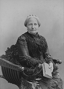
DonaTeresa Cristina (14 March 1822–28 December 1889), nicknamed "the Mother of the Brazilians", was Empress of Brazil as the consort of Emperor DomPedroII from their marriage on 30 May 1843 until 15 November 1889, when the monarchy was abolished. Born a princess of the Kingdom of the Two Sicilies in present-day southern Italy, Teresa Cristina was the daughter of King DonFrancescoI (FrancisI) of the Italian branch of the House of Bourbon and his wife Maria Isabel (Maria Isabella). It was long believed by historians that the Princess was raised in an ultra-conservative, intolerant atmosphere which resulted in a timid and unassertive character in public and an ability to be contented with very little materially or emotionally. Recent studies revealed a more complex character, who despite having respected the social norms of the era, was able to assert a limited independence due to her strongly opinionated personality as well as her interest in learning, sciences and culture.
The Princess was married by proxy to PedroII in 1843. Her spouse's expectations had been raised when a portrait was presented that depicted Teresa Cristina as an idealized beauty, but he was displeased by his bride's appearance upon their first meeting later that year. Despite a cold beginning on the part of Pedro, the couple's relationship improved as time passed, due primarily to Teresa Cristina's patience, kindness and generosity. These traits also helped her win the hearts of the Brazilian people, and her distance from political controversies shielded her from criticism. She also sponsored archaeological studies in Italy and Italian immigration to Brazil. (Full article...)
Image 9
Suillus luteus is a bolete fungus, and the type species of the genus Suillus. A common fungus native all across Eurasia from Ireland to Korea, it has been introduced widely elsewhere, including North and South America, southern Africa, Australia and New Zealand. Commonly referred to as slippery jack or sticky bun in English-speaking countries, its names refer to the brown cap, which is characteristically slimy in wet conditions. The fungus, initially described as Boletus luteus ("yellow mushroom") by Carl Linnaeus in 1753, is now classified in a different fungus family as well as genus. Suillus luteus (literally "yellow pig", from its greasy look in rain) is edible, though not as highly regarded as other bolete mushrooms. It is commonly prepared and eaten in soups, stews or fried dishes. The slime coating, however, may cause indigestion if not removed before eating. It is often sold as a dried mushroom.
The fungus grows in coniferous forests in its native range, and pine plantations in countries where it has become naturalized. It forms symbioticectomycorrhizal associations with living trees by enveloping the tree's underground roots with sheaths of fungal tissue. The fungus produces spore-bearing fruit bodies, often in large numbers, above ground in summer and autumn. The fruit body cap often has a distinctive conical shape before flattening with age, reaching up to 13cm (5in) in diameter. Like other boletes, it has tubes extending downward from the underside of the cap, rather than gills; spores escape at maturity through the tube openings, or pores. The pore surface is yellow, and covered by a membranous partial veil when young. The pale stipe, or stem, measures up to 10cm (4in) tall and 3cm (1.2in) thick and bears small dots near the top. Unlike most other boletes, it bears a distinctive membranous ring that is tinged brown to violet on the underside. (Full article...)
In the precolonial era, the village's area was inhabited by a band of the Wappinger tribes of Native Americans. In the early 19th century, the area was known as Whitson's Corners. Walter William Law moved to the area and purchased lands during the 1890s. Law developed the village, establishing schools, churches, parks, and the Briarcliff Lodge. Briarcliff Manor was incorporated as a village in 1902, and celebrated its centennial on November 21, 2002. The village has grown from 331 people when established to 7,867 in the 2010 census. (Full article...)
Little Butte Creek's watershed was originally settled by the Takelma, and possibly the Shasta tribes of Native Americans. In the Rogue River Wars of the 1850s, most of the Native Americans were either killed or forced onto Indian reservations. Early settlers named Little Butte Creek and nearby Big Butte Creek after their proximity to Mount McLoughlin, which was known as Snowy Butte. In the late 19th century, the watershed was primarily used for agriculture and lumber production. The city of Eagle Point was incorporated in 1911, and remains the only incorporated town within the watershed's boundaries. (Full article...)
Image 12
William FeinerSJ (born Wilhelm Feiner; December 27, 1792 – June 9, 1829) was a German Catholic priest and Jesuit who became a missionary to the United States and eventually the president of Georgetown College, now known as Georgetown University.
Bruce had spent most of the 1890s engaged on expeditions to the Antarctic and Arctic regions, and by 1899 was Britain's most experienced polar scientist. In March of that year, he applied to join the Discovery Expedition; however, his proposal to extend that expedition's field of work into the Weddell Sea quadrant, using a second ship, was dismissed as "mischievous rivalry" by Royal Geographical Society (RGS) president Sir Clements Markham. Bruce reacted by obtaining independent finance; his venture was supported and promoted by the Royal Scottish Geographical Society. (Full article...)
Image 14
Aeneas Lionel Acton Mackintosh (1 July 1879– 8 May 1916) was a British Merchant Navy officer and Antarctic explorer who commanded the Ross Sea party as part of Sir Ernest Shackleton's Imperial Trans-Antarctic Expedition, 1914–1917. The Ross Sea party's mission was to support Shackleton's proposed transcontinental march by laying supply depots along the latter stages of the march's intended route. In the face of persistent setbacks and practical difficulties, Mackintosh's party fulfilled its task, although he and two others died in the course of their duties. Mackintosh's first Antarctic experience was as second officer on Shackleton's Nimrod expedition, 1907–1909. Shortly after his arrival in the Antarctic, a shipboard accident destroyed his right eye, and he was sent back to New Zealand. He returned in 1909 to participate in the later stages of the expedition; his will and determination in adversity impressed Shackleton, and led to his Ross Sea party appointment in 1914.
Having brought his party to the Antarctic, Mackintosh was faced with numerous difficulties. Confused and vague orders meant he was uncertain of the timing of Shackleton's proposed march. His problems were compounded when the party's ship, SY Aurora, was swept from its winter moorings during a gale and was unable to return, causing the loss of vital equipment and supplies. In carrying out the party's depot-laying task, one man died; Mackintosh barely survived, owing his life to the actions of his comrades who brought him to safety. Restored to health, he and a companion disappeared while attempting to return to the expedition's base camp by crossing the unstable sea ice. Mackintosh's competence and leadership skills have been questioned by polar historians. Shackleton commended the work of the party, and equated the sacrifice of their lives to those given in the trenches of the First World War, but was critical of Mackintosh's organising skills. Years later, Shackleton's son, Lord Shackleton, identified Mackintosh as one of the expedition's heroes, alongside Ernest Joyce and Dick Richards. (Full article...)
Cleveland was founded in 1796 near the mouth of the Cuyahoga River as part of the Connecticut Western Reserve by General Moses Cleaveland, after whom the city was named. Its location on the river and the lake shore allowed it to grow into a major commercial and industrial metropolis by the late 19th century, attracting large numbers of immigrants and migrants. It was among the top 10 largest U.S. cities by population for much of the 20th century, a period that saw the development of the city's cultural institutions. By the 1960s, Cleveland's economy began to slow down as manufacturing declined and suburbanization occurred. The city has since developed a diversified economy and gained a national reputation as a center for healthcare and the arts. (Full article...)
The sinusoidal projection is a pseudocylindrical equal-areamap projection. Used as early as the 16th century, this projection shows distances accurately along the central meridian and the equator; areas furthest from these lines are the most distorted.
This picture is a panoramic map of North Cascades National Park, as viewed from the east, created in 1987 by Austrian painter and cartographer Heinrich C. Berann for the National Park Service.
A satellite image of the Scandinavian Peninsula in winter. The peninsula, approximately 1,850 kilometers (1,150 miles) long with a width varying between approximately 370–805km (230–500mi), making it the largest in Europe, is located in the northern part of the continent and consists of Norway, Sweden and part of Finland. Much of the population is concentrated in the southern part of the peninsula; Stockholm and Gothenburg, both in Sweden, and Oslo in Norway are the largest cities.
The Kavrayskiy VII projection is a map projection invented by Vladimir V. Kavrayskiy in 1939 as a general purpose pseudocylindrical projection. It produces maps with low overall distortion, despite its straight, evenly-spaced parallels and a simple formulation.
Author: John Mitchell; scan: Library of Congress, Geography and Map Division.
The Mitchell Map is the most comprehensive map of eastern North America made during the colonial era. Measuring about 6.5ft (2.0m) wide by 4.5ft (1.4m) high, it was produced by John Mitchell in 1757 in eight separate sheets. The map was used during the Treaty of Paris for defining the boundaries of the United States, and remains important today for resolving border disputes.
An animation showing the unfolding of a Dymaxion map, a projection of a world map onto the surface of a polyhedron (in this case, an icosahedron) and then flattened to form a two-dimensional map which retains most of the relative proportional integrity of the globe map. This type of map was invented by Buckminster Fuller and is one of several of his inventions to use the name Dymaxion.
The azimuthal equidistant projection is an azimuthalmap projection in which all points on the map are both proportionately correct distances from the center point and at the correct azimuth (direction) from the center point. Distances and directions to all places, however, are true only from the center point of projection. This projection has been used for the flag of the United Nations, for the USGSNational Atlas of the United States of America, and for large-scale mapping of Micronesia, among others.
The Lambert conformal conic projection is a conic map projection used for aeronautical charts, portions of the State Plane Coordinate System, and many national and regional mapping systems. It is one of seven projections introduced by Johann Heinrich Lambert in 1772. Conceptually, the projection seats a cone over the sphere of the Earth and projects the surface conformally onto the cone. The cone is unrolled, and the parallel that was touching the sphere is assigned unit scale. By scaling the resulting map, two parallels can be assigned unit scale, with scale decreasing between them and increasing outside them. Unlike other conic projections, no true secant form of this projection exists.
A world map entitled Nova totius terrarum orbis tabula Amstelodami, created in 1689 by Gerard van Schagen. This map, created in Amsterdam, measures 48.3 by 56.0 centimetres (19.0 by 22.0in) in size and was made using copper engraving.
The van der Grinten projection is a compromise map projection that is neither equal-area nor conformal. It projects the entire Earth into a circle, though the polar regions are subject to extreme distortion. The projection was the first of four proposed by Alphons J. van der Grinten in 1904, and, unlike perspective projections, is an arbitrary geometric construction on the plane. It was adopted as the National Geographic Society's reference map of the world from 1922 until 1988.
A composite satellite image of the geography of Africa, the Earth's second-largest continent, and its adjacent islands. Separated from Europe by the Mediterranean Sea and from much of Asia by the Red Sea, Africa is joined to Asia at its northeast extremity by the Isthmus of Suez. For geopolitical purposes, the Sinai Peninsula– east of the Suez Canal– is often considered part of Africa, although geographically it belongs in Asia. Africa can be divided into a number of geographic zones: The Atlas Mountains in the north, the Sahara, the coastal plains, and the inner plateaus.
Map: Strebe, using the Geocart map projection software
A two-point equidistant projection of Eurasia. All distances of other points from the two points marked in red (45°N 40°E and 30°N 110°E) are correct. This map is a derivative of NASA's Blue Marble summer month composite, with oceans lightened to enhance legibility and contrast.
In his Dream Pool Essays or Dream Torrent Essays (夢溪筆談; Mengxi Bitan) of 1088, Shen was the first to describe the magnetic needle compass, which would be used for navigation (first described in Europe by Alexander Neckam in 1187). Shen discovered the concept of true north in terms of magnetic declination towards the north pole, with experimentation of suspended magnetic needles and "the improved meridian determined by Shen's [astronomical] measurement of the distance between the pole star and true north". This was the decisive step in human history to make compasses more useful for navigation, and may have been a concept unknown in Europe for another four hundred years (evidence of German sundials made circa 1450 show markings similar to Chinese geomancers' compasses in regard to declination). (Full article...)
A map of the United States showing its 50 states, federal district and five inhabited territories. Alaska, Hawaii, and the territories are shown at different scales, and the Aleutian Islands and the uninhabitednorthwestern Hawaiian Islands are omitted from this map. The United States of America is a federal republic consisting of 50 states, a federal district (Washington, D.C., the capital city of the United States), five major territories, and various minor islands. Both the states and the United States as a whole are each sovereign jurisdictions. The Tenth Amendment to the United States Constitution allows states to exercise all powers of government not delegated to the federal government. Each state has its own constitution and government, and all states and their residents are represented in the federal Congress, a bicameral legislature consisting of the Senate and the House of Representatives. Each state is represented by two senators, while representatives are distributed among the states in proportion to the most recent constitutionally mandated decennial census. Additionally, each state is entitled to select a number of electors to vote in the Electoral College, the body that elects the president of the United States, equal to the total of representatives and senators in Congress from that state. The federal district does not have representatives in the Senate, but has a non-voting delegate in the House, and it is also entitled to electors in the Electoral College. Congress can admit more states, but it cannot create a new state from territory of an existing state or merge two or more states into one without the consent of all states involved, and each new state is admitted on an equal footing with the existing states. (Full article...)
Image 2
Generation Z (often shortened to Gen Z), colloquially known as Zoomers, is the demographiccohort succeeding Millennials and preceding Generation Alpha. Researchers and popular media use the mid-to-late 1990s as starting birth years and the early 2010s as ending birth years. Most members of Generation Z are the children of Generation X or older Millennials. (Full article...)
Millennials, also known as Generation Y (often shortened to Gen Y), are the demographic cohort following Generation X and preceding Generation Z. Researchers and popular media use the early 1980s as starting birth years and the mid-1990s to early 2000s as ending birth years, with the generation typically being defined as people born from 1981 to 1996. Most Millennials are the children of Baby Boomers and older Generation X. In turn Millennials are often the parents of Generation Alpha. (Full article...)
Generation X (often shortened to Gen X) is the demographic cohort following the Baby Boomers and preceding Millennials. Researchers and popular media often use the mid-1960s as its starting birth years and the late 1970s as its ending birth years, with the generation being generally defined as people born from 1965 to 1980. By this definition and U.S. Census data, there are 65.2 million Gen Xers in the United States as of 2019. Most of Generation X are the children of the Silent Generation and early Baby Boomers; Xers are also often the parents of Millennials and Generation Z. (Full article...)

 Featured article - load new batch
 Image 1
 One of Molyneux's celestial globes, which is displayed in Middle Temple Library – from the frontispiece of the Hakluyt Society's 1889 reprint of A Learned Treatise of Globes, both Cœlestiall and Terrestriall, one of the English editions of Robert Hues' Latin work Tractatus de Globis (1594)
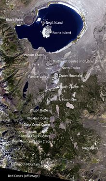 Annotated satellite image of the chain
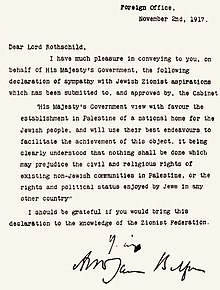 The original letter from Balfour to Rothschild; the declaration reads:
 Caxias in 1878
 Lithograph of Weissenburg in 1902
 November 2022 satellite image of the glacier by Sentinel-2.
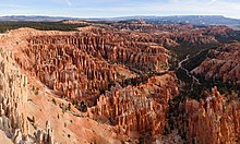
 Portrait by Nadar, c. 1888
 Clockwise from top: the Village Center; village pool at Law Memorial Park; Briarcliff High School; Briarcliff Manor Public Library; village clock and Municipal Building.
 The north fork of Little Butte Creek


.jpg)


 Vital article

 Image 1Map: Strebe, using GeocartThe sinusoidal projection is a pseudocylindrical equal-area map projection. Used as early as the 16th century, this projection shows distances accurately along the central meridian and the equator; areas furthest from these lines are the most distorted.
 Image 2Map credit: Heinrich C. BerannNorth Cascades National Park is an American national park in the state of Washington. At more than 500,000 acres (200,000 ha), North Cascades National Park is the largest of the three National Park Service units that comprise the North Cascades National Park Complex. North Cascades National Park consists of a northern and southern section, bisected by the Skagit River that flows through Ross Lake National Recreation Area. Lake Chelan National Recreation Area lies on the southern border of the south unit of the park. In addition to the two national recreation areas, other protected lands including several national forests and wilderness areas, as well as Canadian provincial parks in British Columbia, nearly surround the park. North Cascades National Park features the rugged mountain peaks of the North Cascades Range, the most expansive glacial system in the contiguous United States, the headwaters of numerous waterways, and vast forests with the highest degree of flora biodiversity of any American national park.
 Image 3Map: Strebe, using GeocartThe Peirce quincuncial projection is a conformal map projection developed by Charles Sanders Peirce in 1879, while he was working at the U.S. Coast and Geodetic Survey. In the normal aspect Peirce's projection presents the Northern Hemisphere in a square; the Southern Hemisphere is split into four 90°–45°–45° triangles surrounding it so that the whole map forms a larger square.
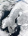 Image 4A satellite image of the Scandinavian Peninsula in winter. The peninsula, approximately 1,850 kilometers (1,150 miles) long with a width varying between approximately 370–805 km (230–500 mi), making it the largest in Europe, is located in the northern part of the continent and consists of Norway, Sweden and part of Finland. Much of the population is concentrated in the southern part of the peninsula; Stockholm and Gothenburg, both in Sweden, and Oslo in Norway are the largest cities.
 Image 5Map: Strebe, using GeocartThe Kavrayskiy VII projection is a map projection invented by Vladimir V. Kavrayskiy in 1939 as a general purpose pseudocylindrical projection. It produces maps with low overall distortion, despite its straight, evenly-spaced parallels and a simple formulation.
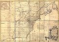 Image 6Author: John Mitchell; scan: Library of Congress, Geography and Map Division.The Mitchell Map is the most comprehensive map of eastern North America made during the colonial era. Measuring about 6.5 ft (2.0 m) wide by 4.5 ft (1.4 m) high, it was produced by John Mitchell in 1757 in eight separate sheets. The map was used during the Treaty of Paris for defining the boundaries of the United States, and remains important today for resolving border disputes.
 Image 7Image: Chris RywaltAn animation showing the unfolding of a Dymaxion map, a projection of a world map onto the surface of a polyhedron (in this case, an icosahedron) and then flattened to form a two-dimensional map which retains most of the relative proportional integrity of the globe map. This type of map was invented by Buckminster Fuller and is one of several of his inventions to use the name Dymaxion.
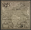 Image 8Map: Diego Gutiérrez and Hieronymus CockAmericae Sive Quartae Orbis Partis Nova Et Exactissima Descriptio is an ornate geographical map of the Americas made in 1562 by Spanish cartographer Diego Gutiérrez and Flemish artist Hieronymus Cock. The map encompasses the eastern coast of North America, the whole of Central and South America, and parts of the western coasts of Europe and Africa. This is the earliest scale wall map of the New World and the first to use the name "California". Two extant copies are known.
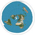 Image 9Map: Strebe, using GeocartThe azimuthal equidistant projection is an azimuthal map projection in which all points on the map are both proportionately correct distances from the center point and at the correct azimuth (direction) from the center point. Distances and directions to all places, however, are true only from the center point of projection. This projection has been used for the flag of the United Nations, for the USGS National Atlas of the United States of America, and for large-scale mapping of Micronesia, among others.
 Image 10Map: Strebe, using GeocartThe Lambert conformal conic projection is a conic map projection used for aeronautical charts, portions of the State Plane Coordinate System, and many national and regional mapping systems. It is one of seven projections introduced by Johann Heinrich Lambert in 1772. Conceptually, the projection seats a cone over the sphere of the Earth and projects the surface conformally onto the cone. The cone is unrolled, and the parallel that was touching the sphere is assigned unit scale. By scaling the resulting map, two parallels can be assigned unit scale, with scale decreasing between them and increasing outside them. Unlike other conic projections, no true secant form of this projection exists.
 Image 11A world map entitled Nova totius terrarum orbis tabula Amstelodami, created in 1689 by Gerard van Schagen. This map, created in Amsterdam, measures 48.3 by 56.0 centimetres (19.0 by 22.0 in) in size and was made using copper engraving.
 Image 12Map: Strebe, using GeocartThe van der Grinten projection is a compromise map projection that is neither equal-area nor conformal. It projects the entire Earth into a circle, though the polar regions are subject to extreme distortion. The projection was the first of four proposed by Alphons J. van der Grinten in 1904, and, unlike perspective projections, is an arbitrary geometric construction on the plane. It was adopted as the National Geographic Society's reference map of the world from 1922 until 1988.
 Image 13Photo: NASAA composite satellite image of the geography of Africa, the Earth's second-largest continent, and its adjacent islands. Separated from Europe by the Mediterranean Sea and from much of Asia by the Red Sea, Africa is joined to Asia at its northeast extremity by the Isthmus of Suez. For geopolitical purposes, the Sinai Peninsula – east of the Suez Canal – is often considered part of Africa, although geographically it belongs in Asia. Africa can be divided into a number of geographic zones: The Atlas Mountains in the north, the Sahara, the coastal plains, and the inner plateaus.
 Image 14Map: Strebe, using the Geocart map projection softwareA two-point equidistant projection of Eurasia. All distances of other points from the two points marked in red (45°N 40°E and 30°N 110°E) are correct. This map is a derivative of NASA's Blue Marble summer month composite, with oceans lightened to enhance legibility and contrast.
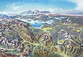 Image 15Map credit: Heinrich C. BerannYellowstone National Park is an American national park located mostly in Wyoming and extending into Montana and Idaho. It was established by the U.S. Congress and signed into law by President Ulysses S. Grant on March 1, 1872. Yellowstone was the first national park in the U.S. and is also widely held to be the first national park in the world. The park is known for its wildlife and its many geothermal features, especially the Old Faithful geyser, one of its most popular landmarks. It has many types of ecosystems, but the subalpine forest is the most abundant. The park is part of the South Central Rockies forests ecoregion. In 1978, Yellowstone was named a World Heritage Site by UNESCO.


.jpg)


.jpg)


 River Thames and Tower Bridge with The Shard and Southwark (left), Tower of London and City of London (right)

.svg)

.jpeg)


 Categories
 Commons
 Wikibooks
 Wikidata
 Wikinews
 Wikiquote
 Wikisource
 Wikiversity
 Wikivoyage
 Wiktionary


