
Nettersheim
Municipality in North Rhine-Westphalia, Germany / From Wikipedia, the free encyclopedia
Dear Wikiwand AI, let's keep it short by simply answering these key questions:
Can you list the top facts and stats about Nettersheim?
Summarize this article for a 10 year old
SHOW ALL QUESTIONS
Nettersheim is a municipality in the district of Euskirchen in the state of North Rhine-Westphalia, Germany. It is located in the Eifel hills, approx. 20 km south-west of Euskirchen. The rivers Erft and Urft have their source in the municipality.
Quick Facts Country, State ...
Nettersheim | |
|---|---|
 | |
 Flag  Coat of arms | |
Location of Nettersheim within Euskirchen district 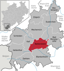 | |
 Nettersheim  Nettersheim | |
| Coordinates: 50°29′33″N 6°37′47″E | |
| Country | Germany |
| State | North Rhine-Westphalia |
| Admin. region | Köln |
| District | Euskirchen |
| Government | |
| • Mayor (2020–25) | Norbert Crump[1] (CDU) |
| Area | |
| • Total | 94.35 km2 (36.43 sq mi) |
| Highest elevation | 590 m (1,940 ft) |
| Lowest elevation | 350 m (1,150 ft) |
| Population (2022-12-31)[2] | |
| • Total | 7,991 |
| • Density | 85/km2 (220/sq mi) |
| Time zone | UTC+01:00 (CET) |
| • Summer (DST) | UTC+02:00 (CEST) |
| Postal codes | 53947 |
| Dialling codes | 02486 |
| Vehicle registration | EU |
| Website | www |
Close