
Mykonos
Regional unit and municipality in Greece / From Wikipedia, the free encyclopedia
Dear Wikiwand AI, let's keep it short by simply answering these key questions:
Can you list the top facts and stats about Mykonos?
Summarize this article for a 10 year old
Mykonos (/ˈmɪkənɒs, -noʊs/,[2][3] UK also /ˈmiːk-/;[4] Greek: Μύκονος [ˈmikonos]) is a Greek island, part of the Cyclades, lying between Tinos, Syros, Paros and Naxos. The island has an area of 85.5 square kilometres (33.0 sq mi) and rises to an elevation of 341 metres (1,119 feet) at its highest point. At the 2021 census, there were 10,704 inhabitants, most of whom lived in the largest town, Mykonos, which is on the west coast. The town is also known as Chora (i.e. 'Town' in Greek, following the common practice in Greece when the name of the island itself is the same as the name of the principal town).
Mykonos
Μύκονος Nickname: Νησί των ανέμων (Nisí ton anémon, 'Island of the winds') | |
|---|---|
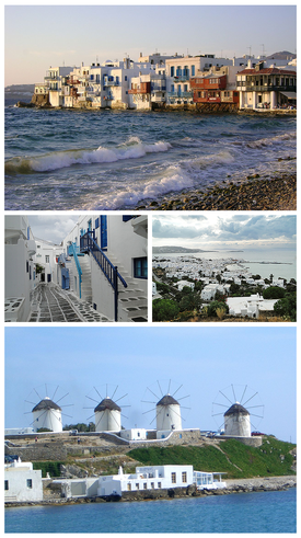 Clockwise from top: View of Little Venice in Mykonos, panoramic view of Chora (Mykonos City), the four windmills of Mykonos and the streets of Chora. | |
| Coordinates: 37°27′32″N 25°21′51″E | |
| Country | Greece |
| Administrative region | South Aegean |
| Area | |
| • Municipality | 85.5 km2 (33.0 sq mi) |
| Population (2021)[1] | |
| • Municipality | 10,704 |
| • Density | 130/km2 (320/sq mi) |
| • Community | 8,609 |
| Demonym | Mykonians |
| Time zone | UTC+2 (EET) |
| • Summer (DST) | UTC+3 (EEST) |
| Postal code | 846 00 |
| Area code(s) | 22890 |
| Website | www |


Mykonos's nickname is "The Island of the Winds",[5][6] due to the very strong winds that usually blow on the island. Tourism is a major industry and Mykonos is known for its vibrant nightlife.[7][8][9]