
McIntosh, Alabama
Town in Alabama, United States / From Wikipedia, the free encyclopedia
Dear Wikiwand AI, let's keep it short by simply answering these key questions:
Can you list the top facts and stats about McIntosh, Alabama?
Summarize this article for a 10 year old
McIntosh, (originally known as McIntosh Bluff[2]), is a town located in Washington County, Alabama, United States along U.S. Route 43. It is 12+1⁄2 miles (20.1 km) south of Wagarville and 44 miles (71 km) north of Mobile. The population as of the 2020 U.S. Census was 206, down from 238 in 2010.
McIntosh, Alabama | |
|---|---|
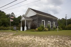 Andrews Chapel in McIntosh | |
 Location of McIntosh in Washington County, Alabama. | |
| Coordinates: 31°15′58″N 88°1′53″W | |
| Country | United States |
| State | Alabama |
| County | Washington |
| Area | |
| • Total | 1.00 sq mi (2.58 km2) |
| • Land | 1.00 sq mi (2.58 km2) |
| • Water | 0.00 sq mi (0.00 km2) |
| Elevation | 49 ft (15 m) |
| Population (2020) | |
| • Total | 206 |
| • Density | 206.83/sq mi (79.85/km2) |
| Time zone | UTC-6 (Central Time (CT)) |
| • Summer (DST) | UTC-5 (CDT) |
| ZIP code | 36553 |
| Area code | 251 |
| FIPS code | 01-45472 |
| GNIS feature ID | 0152280 |
| Website | mcintoshal |
McIntosh is one of the most Native American towns in Alabama, with over half of the town's inhabitants reporting to be of Native descent in the 2020 census
The town and county have a high proportion of residents who are members of the MOWA Band of Choctaw Indians, a state-recognized tribe of people of the Muskogean-speaking language family. It has one site, Andrews Chapel, listed on the National Register of Historic Places.[3]