
La Plata County, Colorado
County in Colorado, United States / From Wikipedia, the free encyclopedia
Dear Wikiwand AI, let's keep it short by simply answering these key questions:
Can you list the top facts and stats about La Plata County, Colorado?
Summarize this article for a 10 year old
SHOW ALL QUESTIONS
La Plata County is a county located in the U.S. state of Colorado. As of the 2020 census, the population was 55,638.[1] The county seat is Durango.[2] The county was named for the La Plata River and the La Plata Mountains. "La plata" means "the silver" in Spanish.
Quick Facts Country, State ...
La Plata County | |
|---|---|
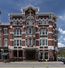 Strater Hotel, opened in 1888 during a mining boom in Durango. | |
 Location within the U.S. state of Colorado | |
 Colorado's location within the U.S. | |
| Coordinates: 37°17′N 107°51′W | |
| Country | |
| State | |
| Founded | February 10, 1874 |
| Named for | Spanish for "the silver" |
| Seat | Durango |
| Largest city | Durango |
| Area | |
| • Total | 1,700 sq mi (4,000 km2) |
| • Land | 1,692 sq mi (4,380 km2) |
| • Water | 7.6 sq mi (20 km2) 0.4% |
| Population (2020) | |
| • Total | 55,638 |
| • Density | 33/sq mi (13/km2) |
| Time zone | UTC−7 (Mountain) |
| • Summer (DST) | UTC−6 (MDT) |
| Congressional district | 3rd |
| Website | co |
Close
La Plata County comprises the Durango, CO Micropolitan Statistical Area.[3][4]
The county is home to Durango Rock Shelters Archeology Site, the type site for the Basketmaker II period of Anasazi culture.