File:Province_of_Chetumal_map.tif
From Wikipedia, the free encyclopedia

Size of this JPG preview of this TIF file: 440 × 599 pixels. Other resolutions: 176 × 240 pixels | 352 × 480 pixels | 564 × 768 pixels | 752 × 1,024 pixels | 1,644 × 2,238 pixels.
Original file (1,644 × 2,238 pixels, file size: 3.51 MB, MIME type: image/tiff)
| This is a file from the Wikimedia Commons. Information from its description page there is shown below. Commons is a freely licensed media file repository. You can help. |
Summary
| DescriptionProvince of Chetumal map.tif |
English: Map 16 in page 160 of The political geography of the Yucatan Maya by Ralph L. Roys [1957, hdl = https://hdl.handle.net/2027/uva.x000422247, licensed under CC0 per HathiTrust] / scale and legend included |
| Date | |
| Source | https://hdl.handle.net/2027/uva.x000422247?urlappend=%3Bseq=168%3Bownerid=27021597765720347-172 |
| Author | Ralph L. Roys |
Licensing
| This file is made available under the Creative Commons CC0 1.0 Universal Public Domain Dedication. | |
| The person who associated a work with this deed has dedicated the work to the public domain by waiving all of their rights to the work worldwide under copyright law, including all related and neighboring rights, to the extent allowed by law. You can copy, modify, distribute and perform the work, even for commercial purposes, all without asking permission.
http://creativecommons.org/publicdomain/zero/1.0/deed.enCC0Creative Commons Zero, Public Domain Dedicationfalsefalse |
Captions
Province of Chetumal / 1957 map by R. L. Roys / via HathiTrust
Items portrayed in this file
depicts
File history
Click on a date/time to view the file as it appeared at that time.
| Date/Time | Thumbnail | Dimensions | User | Comment | |
|---|---|---|---|---|---|
| current | 07:38, 7 August 2023 | 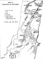 | 1,644 × 2,238 (3.51 MB) | Asdfjrjjj | Uploaded a work by Ralph L. Roys from https://hdl.handle.net/2027/uva.x000422247?urlappend=%3Bseq=168%3Bownerid=27021597765720347-172 with UploadWizard |
File usage
The following pages on the English Wikipedia use this file (pages on other projects are not listed):
Metadata
This file contains additional information, probably added from the digital camera or scanner used to create or digitize it.
If the file has been modified from its original state, some details may not fully reflect the modified file.
| Image title | converted PNM file |
|---|---|
| Width | 1,644 px |
| Height | 2,238 px |
| Bits per component | 8 |
| Compression scheme | Uncompressed |
| Pixel composition | Black and white (Black is 0) |
| Orientation | Normal |
| Number of components | 1 |
| Number of rows per strip | 78 |
| Data arrangement | chunky format |
Retrieved from "https://en.wikipedia.org/wiki/File:Province_of_Chetumal_map.tif"