File:Port_of_Dover_-_view_from_the_White_Cliffs-4101-03.jpg
From Wikipedia, the free encyclopedia
Original file (7,785 × 3,051 pixels, file size: 3.14 MB, MIME type: image/jpeg)
| This is a file from the Wikimedia Commons. Information from its description page there is shown below. Commons is a freely licensed media file repository. You can help. |
Summary
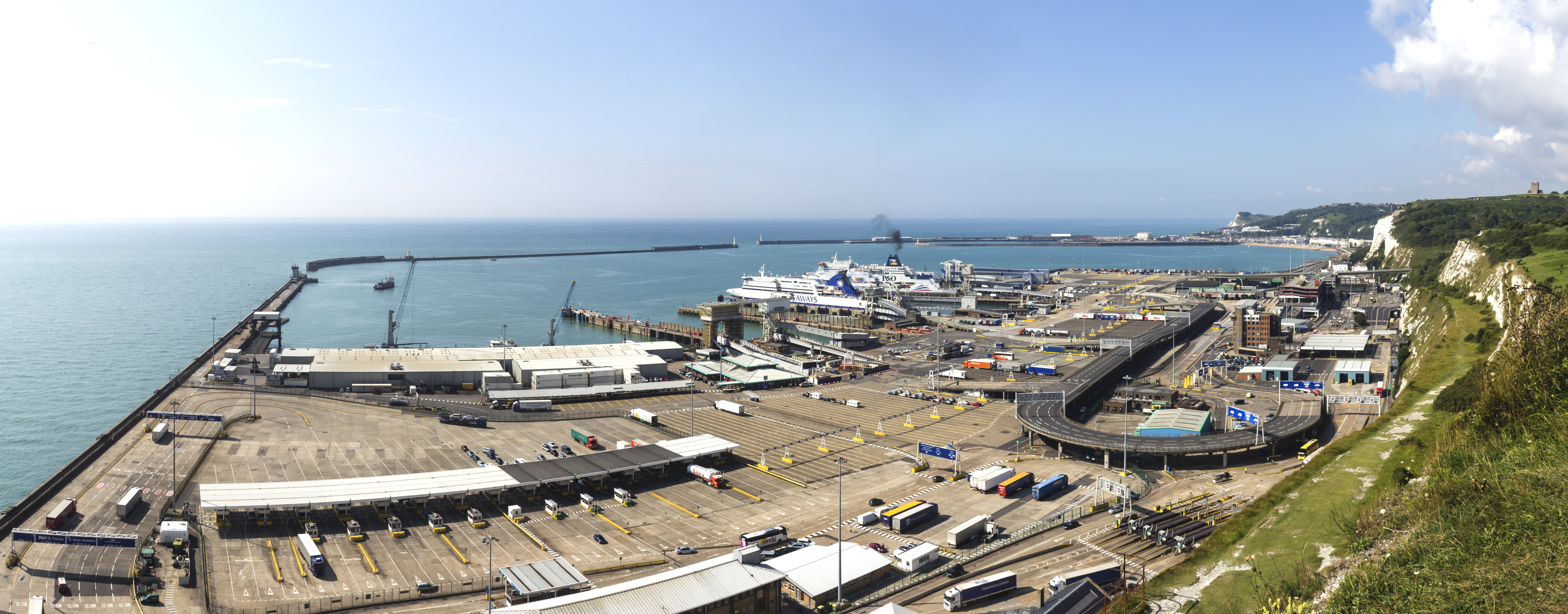
| DescriptionPort of Dover - view from the White Cliffs-4101-03.jpg |
English: Port of Dover - view from the White Cliffs Deutsch: Hafen von Dover. Blick herab von den weißen Klippen von Dover |
|||||||||||||||||
| Date | ||||||||||||||||||
| Source | Own work | |||||||||||||||||
| Author |
creator QS:P170,Q108103612 |
|||||||||||||||||
| Other versions |
|
|||||||||||||||||
| Attribution (required by the license) InfoField | © Raimond Spekking / CC BY-SA 4.0 (via Wikimedia Commons) |
|||||||||||||||||
InfoField | © Raimond Spekking | |||||||||||||||||


| Camera location | 51° 07′ 52.24″ N, 1° 20′ 28.59″ E | View this and other nearby images on: OpenStreetMap |
|---|

|
NOTE: This image is a panorama consisting of 3 frames that were merged or stitched in PanoramaStudio. As a result, this image necessarily underwent some form of digital manipulation. These manipulations may include blending, blurring, cloning, and colour and perspective adjustments. As a result of these adjustments, the image content may be slightly different from reality at the points where multiple images were combined. This manipulation is often required due to lens, perspective, and parallax distortions.
Boarisch | български | dansk | Deutsch | Zazaki | Ελληνικά | English | Canadian English | British English | Esperanto | español | eesti | suomi | français | hrvatski | magyar | italiano | 日本語 | 한국어 | македонски | മലയാളം | Nederlands | polski | português | русский | sicilianu | slovenščina | svenska | Türkçe | українська | العربية | 中文 | +/− |
Licensing
I have published this image as author under the Creative-Commons-Licence CC BY-SA 4.0.. This means that free online usage outside of Wikimedia projects under the following terms of licence is possible:
- The image is credited with "© Raimond Spekking / CC BY-SA 4.0 (via Wikimedia Commons)"
For all other kind of usages (books, journales, flyers, etc.) click on the following button. You will get all information needed.
I would be happy to receive a specimen copy or the URL of the website where the image is used.
Please write an email to raimond.spekking@gmail.com (GPG encrypted emails are welcome: Key-ID: 0xB12BE7A6), if you
- need the image in a higher resolution
- need my postal address for sending a specimen copy
- have further questions to the terms of licence
- You are free:
- to share – to copy, distribute and transmit the work
- to remix – to adapt the work
- Under the following conditions:
- attribution – You must give appropriate credit, provide a link to the license, and indicate if changes were made. You may do so in any reasonable manner, but not in any way that suggests the licensor endorses you or your use.
- share alike – If you remix, transform, or build upon the material, you must distribute your contributions under the same or compatible license as the original.
| Annotations InfoField | This image is annotated: View the annotations at Commons |

Captions
Items portrayed in this file
depicts
51°7'52.24199"N, 1°20'28.59421"E
7 August 2014
File history
Click on a date/time to view the file as it appeared at that time.
| Date/Time | Thumbnail | Dimensions | User | Comment | |
|---|---|---|---|---|---|
| current | 19:04, 6 November 2014 | 7,785 × 3,051 (3.14 MB) | Raymond | User created page with UploadWizard |
File usage
Global file usage
The following other wikis use this file:
- Usage on bn.wikipedia.org
- Usage on ceb.wikipedia.org
- Usage on de.wikipedia.org
- Usage on de.wiktionary.org
- Usage on eu.wikipedia.org
- Usage on fi.wikipedia.org
- Usage on fr.wikipedia.org
- Usage on gv.wikipedia.org
- Usage on hak.wikipedia.org
- Usage on he.wikipedia.org
- Usage on hi.wikipedia.org
- Usage on lt.wikipedia.org
- Usage on no.wikipedia.org
- Usage on pt.wiktionary.org
- Usage on sr.wikipedia.org
- Usage on ta.wikipedia.org
- Usage on www.wikidata.org
- Usage on yi.wikipedia.org
- Usage on zh.wikipedia.org
- Usage on zh.wiktionary.org
Metadata
This file contains additional information, probably added from the digital camera or scanner used to create or digitize it.
If the file has been modified from its original state, some details may not fully reflect the modified file.
| Image title |
|
|---|---|
| Author | Raimond Spekking |
| Copyright holder | |
| Date and time of data generation | 09:14, 7 August 2014 |
| Latitude | 51° 7′ 52.24″ N |
| Longitude | 1° 20′ 28.59″ E |
| Altitude | 25 meters above sea level |
| Short title |
|
| City shown | Dover |
| Horizontal resolution | 72 dpi |
| Vertical resolution | 72 dpi |
| File change date and time | 09:14, 7 August 2014 |
| Y and C positioning | Centered |
| Exif version | 2.3 |
| Date and time of digitizing | 09:14, 7 August 2014 |
| Meaning of each component |
|
| Supported Flashpix version | 1 |
| Color space | Uncalibrated |
| GPS time (atomic clock) | 08:14 |
| Reference for direction of image | True direction |
| Direction of image | 213.62 |
| Geodetic survey data used | WGS-84 |
| Latitude destination | 51° 7′ 34.01″ N |
| Longitude of destination | 1° 20′ 9.28″ E |
| GPS date | 7 August 2014 |
| GPS tag version | 2.2.0.0 |
| Contact information | raimond.spekking@gmail.com
https://de.wikipedia.org/wiki/Benutzer:Raymond
|
| Writer | Raimond Spekking |
| Rating (out of 5) | 5 |
| Code for country shown | GBR |
| Sublocation of city shown | Dover District |
| Country shown | Großbritannien |
| Province or state shown | England |
| IIM version | 4 |