File:Pacific_Theater_Areas;map1.JPG
From Wikipedia, the free encyclopedia
Original file (1,199 × 873 pixels, file size: 351 KB, MIME type: image/jpeg)
| This is a file from the Wikimedia Commons. Information from its description page there is shown below. Commons is a freely licensed media file repository. You can help. |

|
File:Pacific Theater Areas;map1.svg is a vector version of this file. It should be used in place of this JPG file when not inferior.
File:Pacific Theater Areas;map1.JPG → File:Pacific Theater Areas;map1.svg
For more information, see Help:SVG.
|
 |
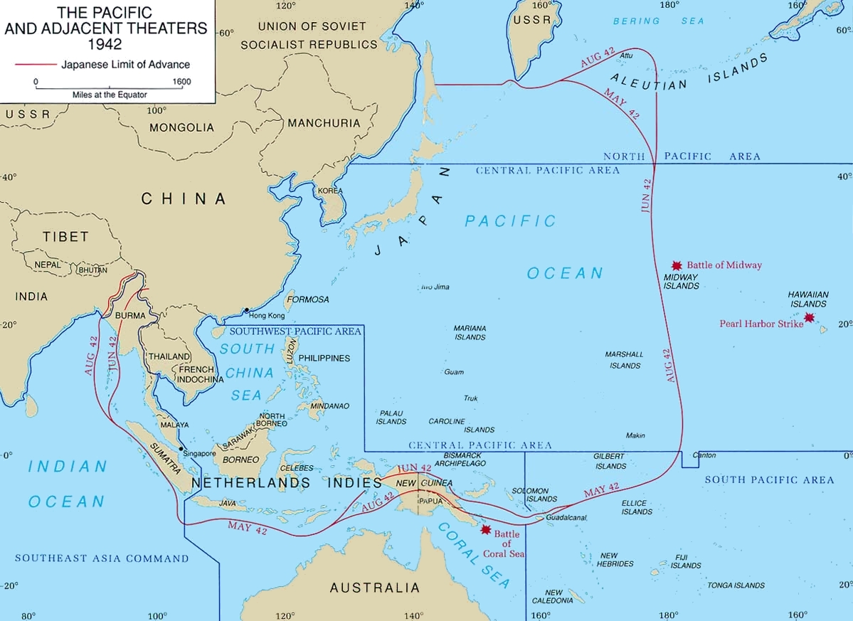
Map of Pacific theater of operations during World War II showing the boundaries of the Japanese Empire. Newell, Clayton R. (2003). Central Pacific. The US Army Campaigns of World War II. US Army Center of Military History. Archived from the original on 2012-02-02. Retrieved on 2008-08-06.
| Public domainPublic domainfalsefalse |
This file is a work of a U.S. Army soldier or employee, taken or made as part of that person's official duties. As a work of the U.S. federal government, it is in the public domain in the United States.
العربية ∙ বাংলা ∙ català ∙ čeština ∙ Deutsch ∙ English ∙ español ∙ eesti ∙ فارسی ∙ suomi ∙ français ∙ hrvatski ∙ magyar ∙ Bahasa Indonesia ∙ italiano ∙ 日本語 ∙ 한국어 ∙ lietuvių ∙ македонски ∙ മലയാളം ∙ မြန်မာဘာသာ ∙ Nederlands ∙ polski ∙ português ∙ русский ∙ sicilianu ∙ српски / srpski ∙ Türkçe ∙ українська ∙ Tiếng Việt ∙ 中文(简体) ∙ 中文(繁體) ∙ +/− |
 |
File history
Click on a date/time to view the file as it appeared at that time.
| Date/Time | Thumbnail | Dimensions | User | Comment | |
|---|---|---|---|---|---|
| current | 20:43, 18 January 2018 | | 1,199 × 873 (351 KB) | Hohum | Cleanup |
| 21:06, 6 March 2005 |  | 1,199 × 873 (142 KB) | Wwoods | Pacific_Theater_Areas; http://www.army.mil/cmh-pg/brochures/72-4/72-4.htm {{PD-USGov-Military-Army}} |
File usage
- Asiatic-Pacific theater
- Cactus Air Force
- Guadalcanal campaign
- Invasion of Tulagi (May 1942)
- Joint Army–Navy Assessment Committee
- Kawaguchi Detachment
- Louis Edward Curdes
- Naval Base Borneo
- Naval Base Gilbert Islands
- Naval Base Iwo Jima
- Naval Base Marshall Islands
- Naval Base Samoa
- Pacific Ocean Areas
- South West Pacific Area
- US Naval Base Australia
- US Naval Base Carolines
- US Naval Base New Guinea
- US Naval Base Solomons
- United States naval bases in the Philippines
- User:Telecineguy/sandbox
- Portal:Maps/Military/1
- Portal:Maps/Some special maps/Military
- Portal:Maps/Some special maps/Military/1
Global file usage
The following other wikis use this file:
- Usage on br.wikipedia.org
- Usage on ca.wikipedia.org
- Usage on ch.wikipedia.org
- Usage on da.wikipedia.org
- Usage on de.wikipedia.org
- Usage on en.wikibooks.org
- Usage on es.wikipedia.org
- Usage on eu.wikipedia.org
- Usage on fa.wikipedia.org
- Usage on fi.wikipedia.org
- Usage on fr.wikipedia.org
- Usage on he.wikipedia.org
- Usage on hu.wikipedia.org
- Usage on id.wikipedia.org
- Usage on it.wikipedia.org
- Usage on ja.wikipedia.org
- Usage on ko.wikipedia.org
- Usage on mk.wikipedia.org
- Usage on ms.wikipedia.org
- Usage on pt.wikipedia.org
- Usage on ro.wikipedia.org
- Usage on ru.wikipedia.org
- Usage on simple.wikipedia.org
- Usage on sv.wikipedia.org
- Usage on ta.wikipedia.org
- Usage on vi.wikipedia.org
- Usage on www.wikidata.org
View more global usage of this file.