File:NPS_pony-express-trail-map.pdf
From Wikipedia, the free encyclopedia
Size of this JPG preview of this PDF file: 800 × 147 pixels. Other resolutions: 320 × 59 pixels | 640 × 117 pixels | 1,024 × 188 pixels | 1,280 × 235 pixels | 6,754 × 1,239 pixels.
Original file (6,754 × 1,239 pixels, file size: 6.75 MB, MIME type: application/pdf)
| This is a file from the Wikimedia Commons. Information from its description page there is shown below. Commons is a freely licensed media file repository. You can help. |
Summary
| DescriptionNPS pony-express-trail-map.pdf |
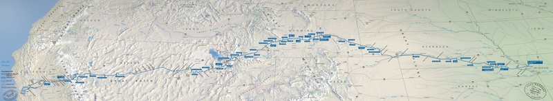
English: Pony Express map, a route protected today by the National Park Service as the Pony Express National Historic Trail. Mail could reach California from Missouri in ten days across eight states. |
| Date | |
| Source | U.S. National Park Service (http://npmaps.com/wp-content/uploads/pony-express-trail-map.pdf) |
| Author | U.S. National Park Service, restoration/cleanup by Matt Holly |
| Other versions |
 |
Licensing
| Public domainPublic domainfalsefalse |
| This image or media file contains material based on a work of a National Park Service employee, created as part of that person's official duties. As a work of the U.S. federal government, such work is in the public domain in the United States. See the NPS website and NPS copyright policy for more information. |
Captions
Add a one-line explanation of what this file represents
Items portrayed in this file
depicts
30 April 2017
File history
Click on a date/time to view the file as it appeared at that time.
| Date/Time | Thumbnail | Dimensions | User | Comment | |
|---|---|---|---|---|---|
| current | 01:28, 17 May 2017 | 6,754 × 1,239 (6.75 MB) | RKBot | =={{int:filedesc}}== {{Information |description= {{en|1=Pony Express map, a route protected today by the National Park Service as the Pony Express National Historic Trail. Mail could reach California from Missouri in ten days across eight states.}} |da... |
File usage
The following pages on the English Wikipedia use this file (pages on other projects are not listed):
Metadata
This file contains additional information, probably added from the digital camera or scanner used to create or digitize it.
If the file has been modified from its original state, some details may not fully reflect the modified file.
| Short title |
|
|---|---|
| Date and time of digitizing | 06:18, 19 August 2016 |
| File change date and time | 06:18, 19 August 2016 |
| Software used | Adobe Illustrator CC 2015 (Macintosh) |
| Date metadata was last modified | 06:18, 19 August 2016 |
| Unique ID of original document | xmp.did:456a137d-4742-490e-b0bf-6767324f383f |
| Conversion program | Adobe PDF library 15.00 |
| Encrypted | no |
| Page size | 3242.81 x 595.275 pts |
| Version of PDF format | 1.5 |
Retrieved from "https://en.wikipedia.org/wiki/File:NPS_pony-express-trail-map.pdf"