File:Muromian-map.png
From Wikipedia, the free encyclopedia

Size of this preview: 588 × 600 pixels. Other resolutions: 235 × 240 pixels | 610 × 622 pixels.
Original file (610 × 622 pixels, file size: 165 KB, MIME type: image/png)
| This is a file from the Wikimedia Commons. Information from its description page there is shown below. Commons is a freely licensed media file repository. You can help. |

|
File:Finno-ugrian-map.svg is a vector version of this file. It should be used in place of this PNG file when not inferior.
File:Muromian-map.png → File:Finno-ugrian-map.svg
For more information, see Help:SVG.
|
 |
Summary
| DescriptionMuromian-map.png |
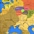
English: An approximate ethno-linguistic map of Kievan Rus' in the 9th century: Five Volga Finnic groups of the Merya, Mari, Muromians, Meshchera and Mordvins are shown as surrounded by the Slavs to the west; the three Finnic groups of the Veps, Ests and Chuds, and Indo-European Balts to the northwest; the Permians to the northeast the (Turkic) Bulghars and Khazars to the southeast and south. |
| Source | File:Finno-ugrian-map.svg states that it is based on Рябинин Е. А. Финно-угорские племена в составе Древней Руси. |
| Author | Wiglaf. |
Licensing

|
Permission is granted to copy, distribute and/or modify this document under the terms of the GNU Free Documentation License, Version 1.2 or any later version published by the Free Software Foundation; with no Invariant Sections, no Front-Cover Texts, and no Back-Cover Texts. A copy of the license is included in the section entitled GNU Free Documentation License.http://www.gnu.org/copyleft/fdl.htmlGFDLGNU Free Documentation Licensetruetrue |
| This file is licensed under the Creative Commons Attribution-Share Alike 3.0 Unported license. | ||
| ||
| This licensing tag was added to this file as part of the GFDL licensing update.http://creativecommons.org/licenses/by-sa/3.0/CC BY-SA 3.0Creative Commons Attribution-Share Alike 3.0truetrue |
Other versions
-
 Español
 -
 Italiano
 -
 Srpski
 -
 suomi
suomi


Captions
Add a one-line explanation of what this file represents
Items portrayed in this file
depicts
File history
Click on a date/time to view the file as it appeared at that time.
| Date/Time | Thumbnail | Dimensions | User | Comment | |
|---|---|---|---|---|---|
| current | 13:47, 9 October 2016 | | 610 × 622 (165 KB) | Julieta39 | No Soviet dam reservoirs 1000 years ago, and differentiation between "Danube-" and "Volga-" Bulgars |
| 00:07, 9 March 2013 |  | 610 × 622 (164 KB) | Martintg | Located Chudes based upon academic sources | |
| 23:10, 10 December 2007 |  | 610 × 622 (144 KB) | Incnis Mrsi | There was no such thing as w:en:Rybinsk Reservoir before "Slavonic tribes" came ☺ | |
| 11:01, 6 October 2006 |  | 610 × 622 (113 KB) | Mets501 | fix tribe name (vepses --> veps) | |
| 13:07, 7 December 2005 |  | 610 × 622 (145 KB) | Joonasl | From en-wiki by [http://en.wikipedia.org/wiki/User:Wiglaf Wiglaf]. Category:Uralic languages {{GFDL}} |
File usage
The following pages on the English Wikipedia use this file (pages on other projects are not listed):
Global file usage
The following other wikis use this file:
- Usage on af.wikipedia.org
- Usage on ang.wikipedia.org
- Usage on be-tarask.wikipedia.org
- Usage on be.wikipedia.org
- Usage on bg.wikipedia.org
- Usage on br.wikipedia.org
- Usage on ca.wikipedia.org
- Usage on cs.wikipedia.org
- Usage on cv.wikipedia.org
- Usage on da.wikipedia.org
- Usage on da.wikibooks.org
- Usage on el.wikipedia.org
- Usage on eo.wikipedia.org
- Usage on es.wikipedia.org
- Usage on et.wikipedia.org
- Usage on eu.wikipedia.org
- Usage on fa.wikipedia.org
- Usage on fi.wikipedia.org
View more global usage of this file.
Metadata
This file contains additional information, probably added from the digital camera or scanner used to create or digitize it.
If the file has been modified from its original state, some details may not fully reflect the modified file.
| Horizontal resolution | 28.35 dpc |
|---|---|
| Vertical resolution | 28.35 dpc |
Retrieved from "https://en.wikipedia.org/wiki/File:Muromian-map.png"