File:Map_of_Enga_Province,_Papua_New_Guinea.pdf
From Wikipedia, the free encyclopedia

Size of this JPG preview of this PDF file: 800 × 520 pixels. Other resolutions: 320 × 208 pixels | 640 × 416 pixels | 1,024 × 666 pixels | 1,377 × 895 pixels.
Original file (1,377 × 895 pixels, file size: 5.26 MB, MIME type: application/pdf)
| This is a file from the Wikimedia Commons. Information from its description page there is shown below. Commons is a freely licensed media file repository. You can help. |
Summary
| DescriptionMap of Enga Province, Papua New Guinea.pdf |
English: A map of Enga Province in Papua New Guinea, made in 2020. It contains several layers: elevation, roads, and major settlements. It was produced by Nelson Minar from data sources including OpenStreetMap, Humanitarian Data Exchange, OpenDEM, and SRTM. It was published in the book "The Absent Presence of the State in Large-Scale Resource Extraction Projects", in Alex Golub's chapter "Restraint Without Control". |
| Date | |
| Source | Own work |
| Author | Nelson Minar |
| Camera location | 5° 30′ 00″ S, 143° 30′ 00″ E | View this and other nearby images on: OpenStreetMap |
|---|
Licensing
I, the copyright holder of this work, hereby publish it under the following license:
This file is licensed under the Creative Commons Attribution-Share Alike 4.0 International license.
- You are free:
- to share – to copy, distribute and transmit the work
- to remix – to adapt the work
- Under the following conditions:
- attribution – You must give appropriate credit, provide a link to the license, and indicate if changes were made. You may do so in any reasonable manner, but not in any way that suggests the licensor endorses you or your use.
- share alike – If you remix, transform, or build upon the material, you must distribute your contributions under the same or compatible license as the original.
Captions
Map of Enga Province, Papua New Guinea
Items portrayed in this file
depicts
3 November 2020
5°30'S, 143°30'E
application/pdf
File history
Click on a date/time to view the file as it appeared at that time.
| Date/Time | Thumbnail | Dimensions | User | Comment | |
|---|---|---|---|---|---|
| current | 22:59, 3 January 2024 | 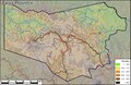 | 1,377 × 895 (5.26 MB) | Nelson Minar | Uploaded own work with UploadWizard |
File usage
The following pages on the English Wikipedia use this file (pages on other projects are not listed):
Global file usage
The following other wikis use this file:
- Usage on ckb.wikipedia.org
- Usage on nl.wikipedia.org
- Usage on pt.wikipedia.org
Metadata
This file contains additional information, probably added from the digital camera or scanner used to create or digitize it.
If the file has been modified from its original state, some details may not fully reflect the modified file.
| Short title | |
|---|---|
| Software used | [[]] |
| Conversion program | Qt 5.11.2 |
| Encrypted | no |
| Page size | 661 x 430 pts |
| Version of PDF format | 1.4 |