File:M_4108712_nw_16_060_20210908_-_Northerly_Island_Crop.tif
From Wikipedia, the free encyclopedia

Size of this JPG preview of this TIF file: 260 × 600 pixels. Other resolutions: 104 × 240 pixels | 208 × 480 pixels | 333 × 768 pixels | 1,208 × 2,787 pixels.
Original file (1,208 × 2,787 pixels, file size: 9.63 MB, MIME type: image/tiff)
| This is a file from the Wikimedia Commons. Information from its description page there is shown below. Commons is a freely licensed media file repository. You can help. |
Summary
| DescriptionM 4108712 nw 16 060 20210908 - Northerly Island Crop.tif |
English: Aerial view of the Northerly Island peninsula and park in Chicago, Illinois taken in September 2021 by the United States Department of Agriculture (USDA) as part of the National Agriculture Imagery Program (NAIP) |
| Date | |
| Source | Image cropped from National Agriculture Imagery Program (NAIP) image available through United States Geological Survey EarthExplorer: https://earthexplorer.usgs.gov/scene/metadata/full/5e83a340bf820c39/3133536/ |
| Author | United States Department of Agriculture - Farm Service Agency |
Licensing
| Public domainPublic domainfalsefalse |
This image is in the public domain in the United States because it only contains materials that originally came from the United States Geological Survey, an agency of the United States Department of the Interior. For more information, see the official USGS copyright policy.
Bahasa Indonesia ∙ català ∙ čeština ∙ Deutsch ∙ eesti ∙ English ∙ español ∙ français ∙ galego ∙ italiano ∙ Nederlands ∙ português ∙ polski ∙ sicilianu ∙ suomi ∙ Tiếng Việt ∙ Türkçe ∙ български ∙ македонски ∙ русский ∙ മലയാളം ∙ 한국어 ∙ 日本語 ∙ 中文 ∙ 中文(简体) ∙ 中文(繁體) ∙ العربية ∙ فارسی ∙ +/− |
Captions
Aerial view of Northerly Island in Chicago, Illinois
Items portrayed in this file
depicts
8 September 2021
image/tiff
File history
Click on a date/time to view the file as it appeared at that time.
| Date/Time | Thumbnail | Dimensions | User | Comment | |
|---|---|---|---|---|---|
| current | 19:11, 1 February 2023 | 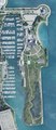 | 1,208 × 2,787 (9.63 MB) | Mindfrieze | Uploaded a work by United States Department of Agriculture - Farm Service Agency from Image cropped from National Agriculture Imagery Program (NAIP) image available through United States Geological Survey EarthExplorer: https://earthexplorer.usgs.gov/scene/metadata/full/5e83a340bf820c39/3133536/ with UploadWizard |
File usage
The following pages on the English Wikipedia use this file (pages on other projects are not listed):
Global file usage
The following other wikis use this file:
- Usage on fr.wikipedia.org
Metadata
This file contains additional information, probably added from the digital camera or scanner used to create or digitize it.
If the file has been modified from its original state, some details may not fully reflect the modified file.
| Width | 1,208 px |
|---|---|
| Height | 2,787 px |
| Bits per component |
|
| Compression scheme | Uncompressed |
| Pixel composition | RGB |
| Orientation | Normal |
| Number of components | 3 |
| Number of rows per strip | 696 |
| Horizontal resolution | 0 dpi |
| Vertical resolution | 0 dpi |
| Data arrangement | chunky format |
| Software used | IrfanView |