File:Lakes_of_Africa.jpg
From Wikipedia, the free encyclopedia
Size of this preview: 595 × 600 pixels. Other resolutions: 238 × 240 pixels | 476 × 480 pixels | 762 × 768 pixels | 1,016 × 1,024 pixels | 2,031 × 2,048 pixels | 4,261 × 4,296 pixels.
Original file (4,261 × 4,296 pixels, file size: 7.42 MB, MIME type: image/jpeg)
| This is a file from the Wikimedia Commons. Information from its description page there is shown below. Commons is a freely licensed media file repository. You can help. |
Summary
| DescriptionLakes of Africa.jpg |
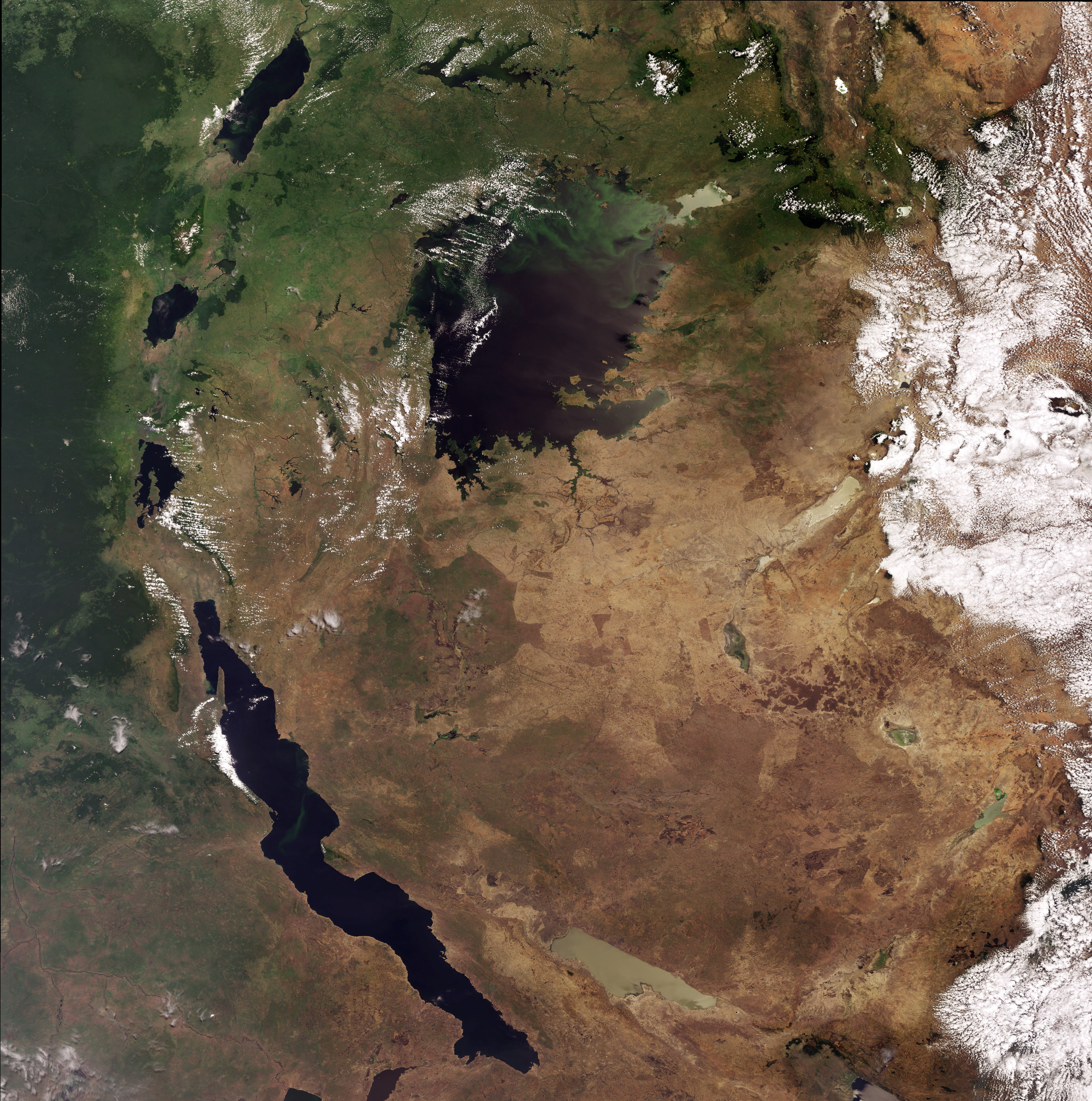
English: This Envisat image highlights lakes in the Western Rift of the Great Rift Valley, a geological fault system of Southwest Asia and East Africa: Lake Victoria, visible in the top centre, Kyoga, the lake above Victoria, Tanganyika, the oblong-shaped lake visible in the bottom left, Lake Albert, visible in the top left, Lake Edward, beneath Albert and Lake Kivu, beneath Edward. This image was acquired by Envisat's Medium Resolution Imaging Spectrometer (MERIS) on 6 October 2008, working in Full Resolution Mode providing a spatial resolution of 300 m. |
| Date | |
| Source | http://www.esa.int/spaceinimages/Images/2008/10/Lakes_of_Africa |
| Author | European Space Agency |
| Permission (Reusing this file) |
ESA,CC BY-SA 3.0 IGO |
| Other versions |
|
| Title InfoField | Lakes of Africa |
| Keywords InfoField | Water (fresh); Lakes |
| Set InfoField | Earth observation image of the week |
| Mission InfoField | Envisat |
| Activity InfoField | Observing the Earth |

Licensing
This file is licensed under the Creative Commons Attribution-ShareAlike 3.0 IGO license.
Attribution: ESA
- You are free:
- to share – to copy, distribute and transmit the work
- to remix – to adapt the work
- Under the following conditions:
- attribution – You must give appropriate credit, provide a link to the license, and indicate if changes were made. You may do so in any reasonable manner, but not in any way that suggests the licensor endorses you or your use.
- share alike – If you remix, transform, or build upon the material, you must distribute your contributions under the same or compatible license as the original.
Captions
Add a one-line explanation of what this file represents
Items portrayed in this file
depicts
6 October 2008
File history
Click on a date/time to view the file as it appeared at that time.
| Date/Time | Thumbnail | Dimensions | User | Comment | |
|---|---|---|---|---|---|
| current | 05:25, 2 March 2017 | | 4,261 × 4,296 (7.42 MB) | Revent | =={{int:filedesc}}== {{Photograph |photographer = Envisat satellite |title = Lakes of Africa |description = {{en|1=This Envisat image highlights lakes in the Western Rift of the Great Rift Valley, a geological fault system... |
File usage
The following pages on the English Wikipedia use this file (pages on other projects are not listed):
Global file usage
The following other wikis use this file:
- Usage on eu.wikipedia.org
- Usage on te.wikipedia.org
Metadata
This file contains additional information, probably added from the digital camera or scanner used to create or digitize it.
If the file has been modified from its original state, some details may not fully reflect the modified file.
| Width | 4,261 px |
|---|---|
| Height | 4,296 px |
| Bits per component |
|
| Pixel composition | RGB |
| Number of components | 3 |
| Horizontal resolution | 100 dpi |
| Vertical resolution | 100 dpi |
| Image width | 4,261 px |
| Image height | 4,296 px |
| Color space | sRGB |
| Date and time of digitizing | 14:11, 16 October 2008 |
| File change date and time | 13:20, 23 October 2008 |
| Date metadata was last modified | 13:20, 23 October 2008 |
| Software used | Adobe Photoshop CS3 Macintosh |
Retrieved from "https://en.wikipedia.org/wiki/File:Lakes_of_Africa.jpg"