File:Kukenan_Roraima_GS.jpg
From Wikipedia, the free encyclopedia
Original file (4,851 × 1,533 pixels, file size: 3.64 MB, MIME type: image/jpeg)
| This is a file from the Wikimedia Commons. Information from its description page there is shown below. Commons is a freely licensed media file repository. You can help. |
| This is a featured picture, which means that members of the community have identified it as one of the finest images on the English Wikipedia, adding significantly to its accompanying article. If you have a different image of similar quality, be sure to upload it using the proper free license tag, add it to a relevant article, and nominate it. |
| This image was selected as picture of the day on the English Wikipedia for May 29, 2014. |
Summary
| DescriptionKukenan Roraima GS.jpg |
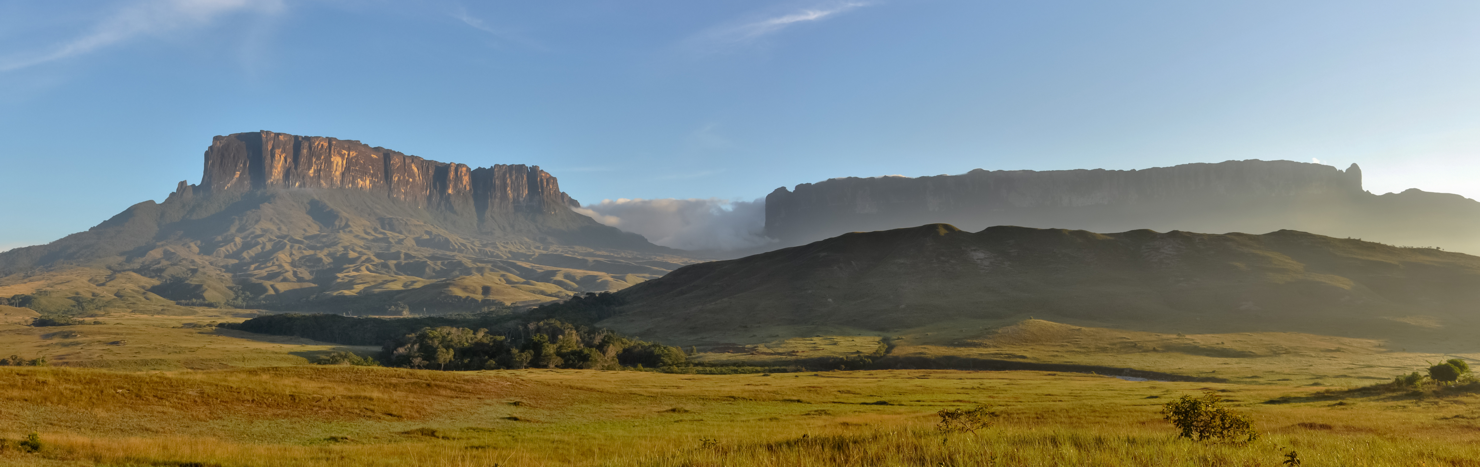
English: Morning view of Kukenan and Roraima tepuis, from Tëk river camp (river visible in the image), in Gran Sabana, Venezuela. Roraima tepui is actually some 100 mts higher than Kukenan, but due to the perspective of the picture, it looks like it is lower.
Español: Vista matutina de los tepuys Kukenan y Roraima, desde el campamente del río Tëk (con el río visible en la imagen), en la Gran Sabana, Venezuela. El tepuy Roraima es en realidad unos cien metros más alto que el Kukenan, aunque por la perspectiva de la foto, parece lo contrario.
Français : Vue matinale sur le Tepuy Kukenan et le Mont Roraima, depuis le camp de la rivière Tëk, dans la Gran Sabana (Vénézuela). Le Roraima Fait 100 m de plus que le Kukenan, bien qu'il apparaisse moins haut sur l'image, à cause de la perspective.
Bosanski: Jutarnja panorama Kukenana i tepui planine Roraima, iz riječnog kampa Tëk, Gran Sabana, Venecuela.
Italiano: Panorama al mattino dei tepui di Kukenan e Roraima dal campo sul fiume Tëk, Gran Sabana in Venezuela.
|
|||
| Date | ||||
| Source | Own work | |||
| Author | Paolo Costa Baldi | |||
| Permission (Reusing this file) |
|
| Camera location | 5° 05′ 46.88″ N, 60° 50′ 47.76″ W | View this and other nearby images on: OpenStreetMap |
|---|
|
This image was selected as picture of the day on Wikimedia Commons for 10 July 2015. It was captioned as follows: Other languages:
Bosanski: Jutarnja panorama Kukenana i tepui planine Roraima, iz riječnog kampa Tëk, Gran Sabana, Venecuela. Español: Vista matutina de los tepuys Kukenan y Roraima, desde el campamente del río Tëk (con el río visible en la imagen), en la Gran Sabana, Venezuela. Italiano: Panorama al mattino dei tepui di Kukenan e Roraima dal campo sul fiume Tëk, Gran Sabana in Venezuela. |
Licensing
- You are free:
- to share – to copy, distribute and transmit the work
- to remix – to adapt the work
- Under the following conditions:
- attribution – You must give appropriate credit, provide a link to the license, and indicate if changes were made. You may do so in any reasonable manner, but not in any way that suggests the licensor endorses you or your use.
- share alike – If you remix, transform, or build upon the material, you must distribute your contributions under the same or compatible license as the original.

|
Permission is granted to copy, distribute and/or modify this document under the terms of the GNU Free Documentation License, Version 1.2 or any later version published by the Free Software Foundation; with no Invariant Sections, no Front-Cover Texts, and no Back-Cover Texts. A copy of the license is included in the section entitled GNU Free Documentation License.http://www.gnu.org/copyleft/fdl.htmlGFDLGNU Free Documentation Licensetruetrue |
| Annotations InfoField | This image is annotated: View the annotations at Commons |
Matawi-tepui (incorrectly called and more well-known as Kukenan Tepui), 2.680 mts. a.s.l.
Roraima-tepui, the highest tepui of Venezuela (almost 2.800 mts. a.s.l., exact altitude still undefined).
Tëk river
Location of Kukenan Falls, 10th highest in the world, with its 600 mts free fall (not visible in the picture because of the dry climate at the moment the picture was taken).
The "Maverick" rock formation, the tallest point in Roraima Mt. (due to the perspective it might not seem the highest point, but it is).
Captions
20 December 2010
5°5'46.882"N, 60°50'47.760"W
image/jpeg
File history
Click on a date/time to view the file as it appeared at that time.
| Date/Time | Thumbnail | Dimensions | User | Comment | |
|---|---|---|---|---|---|
| current | 03:42, 20 October 2011 | 4,851 × 1,533 (3.64 MB) | Paolostefano1412 | {{Information |Description ={{en|1=Morning view of Kukenan and Roraima tepuis, from River Tëk camp (river visible in the image).}} {{es|1=Vista matutina de los tepuys Kukenan y Roraima, desde el campamente del río Tëk (con el río visible en la imag |
File usage
- Distribution of Heliamphora
- Eastern Tepuis
- Gran Sabana
- Raleigh's El Dorado expedition
- Talk:Gran Sabana
- User:Razr Nation/FPs
- User talk:Paolostefano1412
- User talk:Razr Nation/2013/2
- User talk:Razr Nation/2014/4
- Wikipedia:Featured picture candidates/January-2013
- Wikipedia:Featured picture candidates/Kukenan Roraima GS
- Wikipedia:Featured pictures/Places/Panorama
- Wikipedia:Featured pictures thumbs/33
- Wikipedia:Main Page history/2014 May 29
- Wikipedia:Picture of the day/May 2014
- Wikipedia:WikiProject Geology/Automated list of recognized content
- Wikipedia:WikiProject Geology/Recognized content
- Wikipedia:WikiProject Protected areas
- Template:POTD/2014-05-29
- Portal:Venezuela
- Portal:Venezuela/Recognized content
Global file usage
The following other wikis use this file:
- Usage on ast.wikipedia.org
- Usage on av.wikipedia.org
- Usage on az.wikipedia.org
- Usage on be-tarask.wikipedia.org
- Usage on bn.wikipedia.org
- Usage on bs.wikipedia.org
- Usage on crh.wikipedia.org
- Usage on cs.wikipedia.org
- Usage on cv.wikipedia.org
- Usage on cy.wikipedia.org
- Usage on da.wikipedia.org
- Usage on de.wikipedia.org
- Usage on en.wikivoyage.org
- Usage on es.wikipedia.org
- La Gran Sabana
- Anexo:Patrimonio de la Humanidad en América Latina y el Caribe
- Wikipedia:Imágenes destacadas/Lugares/Sudamérica
- Wikipedia:Recurso del día/501 - 600
- Wikipedia:Candidatos a recursos destacados/Diciembre-2011
- Wikipedia:Candidatos a recursos destacados/Kukenan Roraima GS.jpg
- Plantilla:RDD/556
- Wikipedia:Recurso del día/enero de 2012
- Wikipedia:Recurso del día/febrero de 2013
- Usuario discusión:Eduardosalg/Archivo57/Archivo56/Archivo39
- Usuario:JosueCarrion
- Usuario:Eduardosalg/Vitrina
- Usuario:Leanex77
- Wikipedia:Recurso del día/abril de 2015
- Wikipedia:Recurso del día/julio de 2017
- Wikipedia:Recurso del día/septiembre de 2019
- Wikipedia:Recurso del día/abril de 2022
- Usage on es.wikivoyage.org
- Usage on fa.wikipedia.org
- Usage on fr.wikipedia.org
- Usage on he.wikivoyage.org
- Usage on hi.wikipedia.org
- Usage on hu.wikipedia.org
- Usage on hy.wikipedia.org
- Usage on id.wikipedia.org
View more global usage of this file.
Metadata
This file contains additional information, probably added from the digital camera or scanner used to create or digitize it.
If the file has been modified from its original state, some details may not fully reflect the modified file.
| Camera manufacturer | NIKON CORPORATION |
|---|---|
| Camera model | NIKON D90 |
| Date and time of data generation | 06:09, 20 December 2010 |
| User comments |
|
| Horizontal resolution | 240 dpi |
| Vertical resolution | 240 dpi |
| Software used | Hugin 2011.0.0.0fd3e119979c built by Matthew Petroff |
| File change date and time | 23:04, 19 October 2011 |
| Exif version | 2.3 |
| Date and time of digitizing | 06:09, 20 December 2010 |
| Width | 4,851 px |
| Height | 1,533 px |
| Image width | 4,851 px |
| Image height | 1,533 px |