File:KaartNederlandsekolonien.jpg
From Wikipedia, the free encyclopedia
Size of this preview: 731 × 600 pixels. Other resolutions: 293 × 240 pixels | 585 × 480 pixels | 936 × 768 pixels | 1,248 × 1,024 pixels | 1,584 × 1,300 pixels.
Original file (1,584 × 1,300 pixels, file size: 2.39 MB, MIME type: image/jpeg)
| This is a file from the Wikimedia Commons. Information from its description page there is shown below. Commons is a freely licensed media file repository. You can help. |
Summary
| DescriptionKaartNederlandsekolonien.jpg |
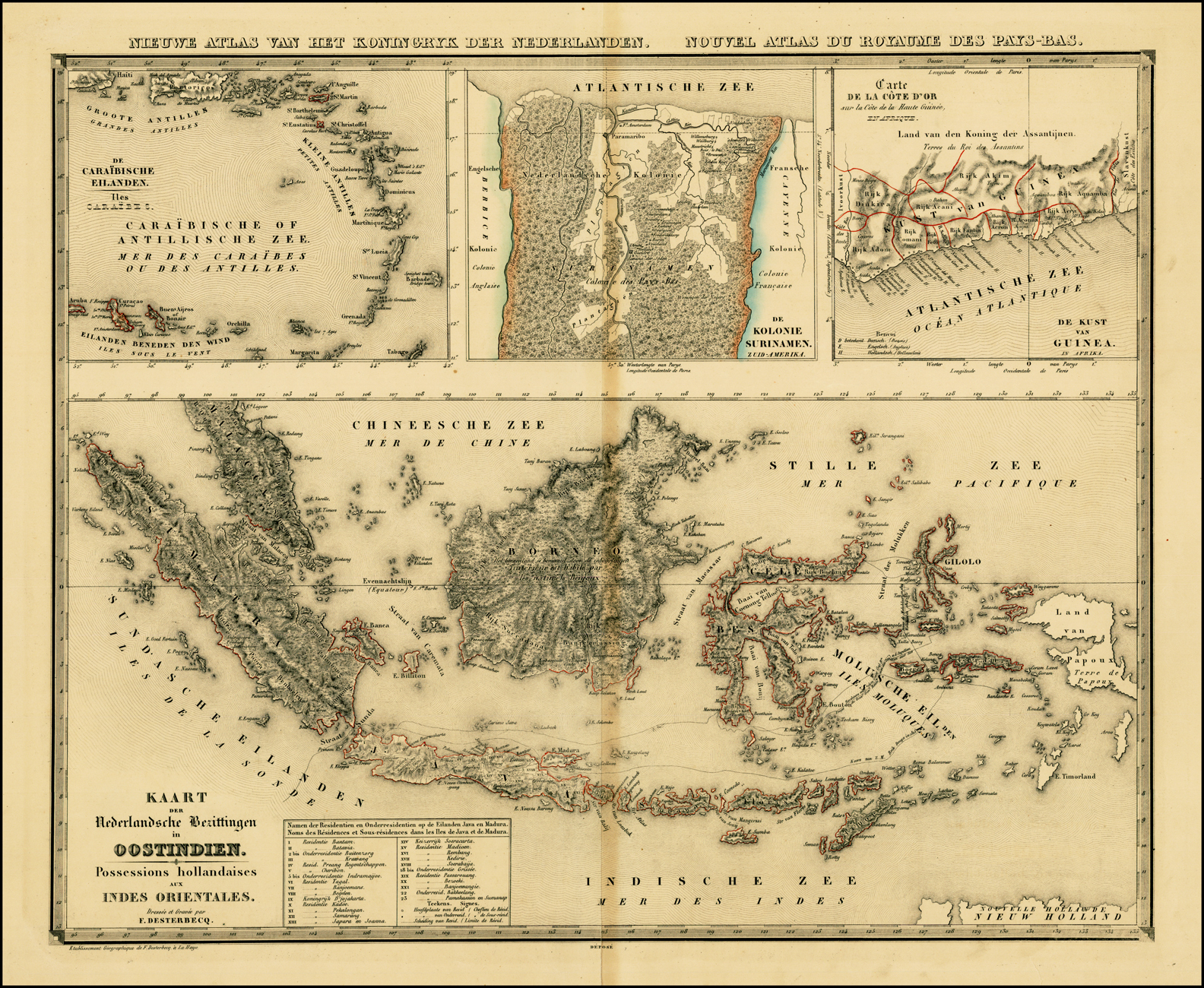
English: Map of the Dutch colonial possessions around 1840, including the Dutch East Indies, Curacao and Dependencies, Suriname, and the Dutch Gold Coast. |
|||||||||||||||||||||||
| Date |
circa 1840 date QS:P,+1840-00-00T00:00:00Z/9,P1480,Q5727902 |
|||||||||||||||||||||||
| Source | Barry Lawrence Ruderman Antique Maps, Inc., taken from Nieuwe atlas van het Koningryk der Nederlanden, benevens het Groot-Hertogdom Luxemburg, het Hertogdom Limburg en de Nederlandsche Bezittingen ten Oosten en ten Westen der Kaap de Goede Hoop | |||||||||||||||||||||||
| Author |
creator QS:P170,Q2315978 |
|||||||||||||||||||||||
.jpg)
Licensing
| Public domainPublic domainfalsefalse |
|
This work is in the public domain in its country of origin and other countries and areas where the copyright term is the author's life plus 100 years or fewer. | |
| This file has been identified as being free of known restrictions under copyright law, including all related and neighboring rights. | |
https://creativecommons.org/publicdomain/mark/1.0/PDMCreative Commons Public Domain Mark 1.0falsefalse
File history
Click on a date/time to view the file as it appeared at that time.
| Date/Time | Thumbnail | Dimensions | User | Comment | |
|---|---|---|---|---|---|
| current | 17:07, 13 December 2011 | | 1,584 × 1,300 (2.39 MB) | Fentener van Vlissingen | {{Information |Description={{en|Map of the Dutch colonial possessions around 1840, including the Dutch East Indies, Curacao and Dependencies, Suriname, and the Dutch Gold Coast.}} |Source=[http://www.raremaps.com/gallery/detail/25562/Kaart_Der_Nederlandsc |
File usage
The following pages on the English Wikipedia use this file (pages on other projects are not listed):
Global file usage
The following other wikis use this file:
- Usage on de.wikipedia.org
- Usage on sl.wikipedia.org
- Usage on th.wikipedia.org
- Usage on vi.wikipedia.org
Metadata
This file contains additional information, probably added from the digital camera or scanner used to create or digitize it.
If the file has been modified from its original state, some details may not fully reflect the modified file.
| Orientation | Normal |
|---|---|
| Horizontal resolution | 0.02 dpi |
| Vertical resolution | 0.02 dpi |
| Software used | Adobe Photoshop CS3 Windows |
| File change date and time | 14:36, 5 November 2010 |
| Color space | sRGB |
| Width | 4,742 px |
| Height | 3,891 px |
| Compression scheme | Uncompressed |
| Pixel composition | RGB |
| Number of components | 3 |
| Image width | 1,584 px |
| Image height | 1,300 px |
| Bits per component |
|
| Date and time of digitizing | 07:35, 5 November 2010 |
| Date metadata was last modified | 07:36, 5 November 2010 |
Retrieved from "https://en.wikipedia.org/wiki/File:KaartNederlandsekolonien.jpg"