File:Edinburgh_map.png
From Wikipedia, the free encyclopedia
No higher resolution available.
Edinburgh_map.png (734 × 573 pixels, file size: 69 KB, MIME type: image/png)
| This is a file from the Wikimedia Commons. Information from its description page there is shown below. Commons is a freely licensed media file repository. You can help. |

|
File:Edinburgh Old Town Boundaries with New Town.svg is a vector version of this file. It should be used in place of this PNG file when not inferior.
File:Edinburgh map.png → File:Edinburgh Old Town Boundaries with New Town.svg
For more information, see Help:SVG.
|
 |
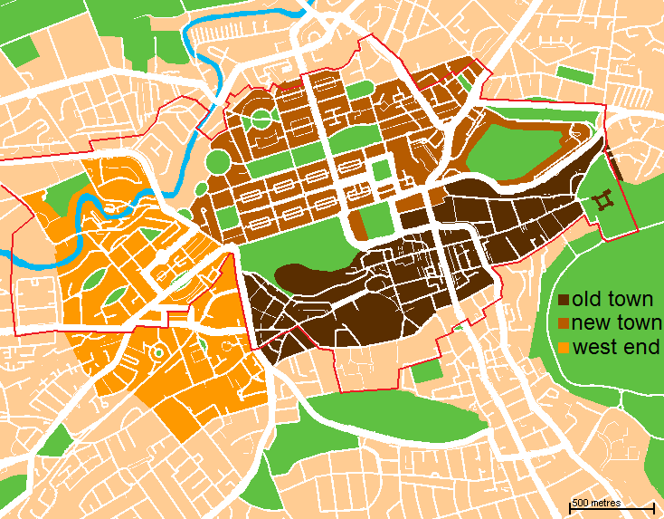
| DescriptionEdinburgh map.png | A map of the city centre of Edinburgh, Scotland. Old Town is in dark brown, New Town in light brown, West End is in yellow, and the World Heritage Site boundary is the red line. | |||
| Date | (UTC) | |||
| Source | Based loosely on http://www.aboutscotland.com/edin/newtown.html, updated based on the 'Edinburgh Navigator' maps. | |||
| Author | Jack · talk · | |||
| Permission (Reusing this file) |
|
| Public domainPublic domainfalsefalse |
| I, the copyright holder of this work, release this work into the public domain. This applies worldwide. In some countries this may not be legally possible; if so: I grant anyone the right to use this work for any purpose, without any conditions, unless such conditions are required by law. |
Captions
Add a one-line explanation of what this file represents
Items portrayed in this file
depicts
File history
Click on a date/time to view the file as it appeared at that time.
| Date/Time | Thumbnail | Dimensions | User | Comment | |
|---|---|---|---|---|---|
| current | 00:03, 8 November 2009 | | 734 × 573 (69 KB) | Jrockley | altered to depict new town, old town, and west end instead. also now shows boundary of world heritage site. |
| 02:58, 19 November 2007 |  | 610 × 516 (47 KB) | Jrockley | more greenery | |
| 17:32, 16 November 2007 |  | 610 × 516 (46 KB) | Jrockley | move "Edinburgh" | |
| 03:43, 16 November 2007 |  | 610 × 516 (47 KB) | Jrockley | more greenery | |
| 03:20, 16 November 2007 |  | 610 × 516 (47 KB) | Jrockley | clearer map, based on Google data | |
| 01:19, 16 November 2007 |  | 500 × 432 (30 KB) | Jrockley | {{Information |Description= Map of Central Edinburgh, showing New and Old Towns. |Source=Based loosely on http://www.aboutscotland.com/edin/newtown.html |Date=~~~~~ |Author=~~~ |Permission={{PD-self}} |other_versions= }} |
File usage
The following pages on the English Wikipedia use this file (pages on other projects are not listed):
- Areas of Edinburgh
- Edinburgh
- List of Category A listed buildings in Edinburgh
- List of Category A listed buildings in the New Town, Edinburgh
- List of Category A listed buildings in the Old Town, Edinburgh
- New Town, Edinburgh
- Old Town, Edinburgh
- West End, Edinburgh
- Talk:Edinburgh/Archive 2
- Wikipedia talk:WikiProject Edinburgh
Global file usage
The following other wikis use this file:
- Usage on af.wikipedia.org
- Usage on ang.wikipedia.org
- Usage on ba.wikipedia.org
- Usage on be.wikipedia.org
- Usage on ca.wikipedia.org
- Usage on cs.wikipedia.org
- Usage on de.wikipedia.org
- Usage on es.wikipedia.org
- Usage on eu.wikipedia.org
- Usage on fi.wikipedia.org
- Usage on fr.wikipedia.org
- Usage on ga.wikipedia.org
- Usage on gl.wikipedia.org
- Usage on he.wikipedia.org
- Usage on hi.wikipedia.org
- Usage on hr.wikipedia.org
- Usage on hy.wikipedia.org
- Usage on ja.wikipedia.org
- Usage on kn.wikipedia.org
- Usage on ko.wikipedia.org
- Usage on nl.wikipedia.org
- Usage on pt.wikipedia.org
- Usage on ru.wikipedia.org
- Usage on sco.wikipedia.org
- Usage on sc.wikipedia.org
- Usage on simple.wikipedia.org
- Usage on sl.wikipedia.org
View more global usage of this file.
Metadata
This file contains additional information, probably added from the digital camera or scanner used to create or digitize it.
If the file has been modified from its original state, some details may not fully reflect the modified file.
| Horizontal resolution | 37.79 dpc |
|---|---|
| Vertical resolution | 37.79 dpc |
Retrieved from "https://en.wikipedia.org/wiki/File:Edinburgh_map.png"