File:Calcareous_Soil_Profile,_Seven_Sisters_Country_Park_-_geograph.org.uk_-_1280181.jpg
From Wikipedia, the free encyclopedia
Calcareous_Soil_Profile,_Seven_Sisters_Country_Park_-_geograph.org.uk_-_1280181.jpg (640 × 430 pixels, file size: 70 KB, MIME type: image/jpeg)
| This is a file from the Wikimedia Commons. Information from its description page there is shown below. Commons is a freely licensed media file repository. You can help. |
Summary
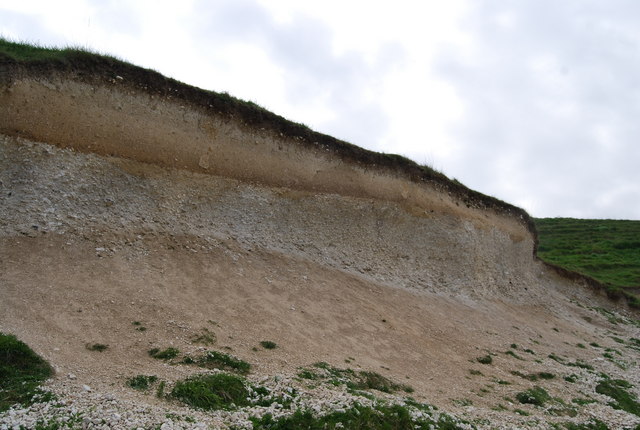
| DescriptionCalcareous Soil Profile, Seven Sisters Country Park - geograph.org.uk - 1280181.jpg |
English: Calcareous Soil Profile, Seven Sisters Country Park A well defined soil profile on chalk.
The dark organic ricn humus layer can clearly be seen at the top of the profile. below it is a bleached horizon where nutrients have been leached out & below this is a darker reddish layer of redeposition. At the base of the profile is the weathered bedrock (chalk)the unweathered chalk is hidden. This soil profile is a Rendzina Rendzina |
| Date | |
| Source | From geograph.org.uk |
| Author | Nigel Chadwick |
| Camera location | 50° 46′ 23″ N, 0° 09′ 22″ E | View this and other nearby images on: OpenStreetMap |
|---|
| Object location | 50° 46′ 22″ N, 0° 09′ 23″ E | View this and other nearby images on: OpenStreetMap |
|---|
Licensing

|
This image was taken from the Geograph project collection. See this photograph's page on the Geograph website for the photographer's contact details. The copyright on this image is owned by Nigel Chadwick and is licensed for reuse under the Creative Commons Attribution-ShareAlike 2.0 license.
|
- You are free:
- to share – to copy, distribute and transmit the work
- to remix – to adapt the work
- Under the following conditions:
- attribution – You must give appropriate credit, provide a link to the license, and indicate if changes were made. You may do so in any reasonable manner, but not in any way that suggests the licensor endorses you or your use.
- share alike – If you remix, transform, or build upon the material, you must distribute your contributions under the same or compatible license as the original.
Captions
Items portrayed in this file
depicts
some value
30 April 2009
50°46'22.58"N, 0°9'21.96"E
50°46'21.90"N, 0°9'23.04"E
image/jpeg
a5f41f303ffc848053716b63c3f858101dc2a846
71,494 byte
430 pixel
640 pixel
File history
Click on a date/time to view the file as it appeared at that time.
| Date/Time | Thumbnail | Dimensions | User | Comment | |
|---|---|---|---|---|---|
| current | 05:41, 27 February 2011 | | 640 × 430 (70 KB) | GeographBot | == {{int:filedesc}} == {{Information |description={{en|1=Calcareous Soil Profile, Seven Sisters Country Park A well defined soil profile on chalk. The dark organic ricn humus layer can clearly be seen at the top of the profile. below it is a bleached hor |
File usage
Global file usage
The following other wikis use this file:
- Usage on ar.wikipedia.org
- Usage on bn.wikipedia.org
- Usage on cy.wikipedia.org
- Usage on de.wikipedia.org
- Usage on es.wikipedia.org
- Usage on fa.wikipedia.org
- Usage on fi.wikipedia.org
- Usage on ha.wikipedia.org
- Usage on la.wikipedia.org
- Usage on mk.wikipedia.org
- Usage on pa.wikipedia.org
- Usage on si.wikipedia.org
- Usage on zh-yue.wikipedia.org
Metadata
This file contains additional information, probably added from the digital camera or scanner used to create or digitize it.
If the file has been modified from its original state, some details may not fully reflect the modified file.
| _error | 0 |
|---|