File:Belgii_novi,_angliae_novae,_et_partis_Virginiae_-_novissima_delineatio._NYPL433965.tiff
From Wikipedia, the free encyclopedia

Original file (4,975 × 4,262 pixels, file size: 60.67 MB, MIME type: image/tiff)
| This is a file from the Wikimedia Commons. Information from its description page there is shown below. Commons is a freely licensed media file repository. You can help. |
Summary
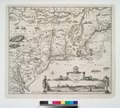
| DescriptionBelgii novi, angliae novae, et partis Virginiae - novissima delineatio. NYPL433965.tiff | Belgii novi, angliae novae, et partis Virginiae : novissima delineatio. | |||||||||||||||||||||||||||||||||||||||||||||||||||||||||||||||||||||||||
| Notes InfoField | At foot of publisher statement: C.P. Note 2.) Described by Campbell as third state of map by Jan Jansson. Note 3.) Includes ill., decorative cartouches, and dedication to Gualthero de Raet. Note 4.) National Endowment for the Humanities Grant for Access to Early Maps of the Middle Atlantic Seaboard. Note 5.) Relief shown pictorially. | |||||||||||||||||||||||||||||||||||||||||||||||||||||||||||||||||||||||||
| Standard reference InfoField | Campbell, T. The Jansson-Visscher maps of New England, 3; NYPL. Dictionary catalog of the Map Division, VII, p. 140 | |||||||||||||||||||||||||||||||||||||||||||||||||||||||||||||||||||||||||
| Physical description InfoField | 1 map : hand col. ; 42 x 50 cm. | |||||||||||||||||||||||||||||||||||||||||||||||||||||||||||||||||||||||||
| Catalog Call Number InfoField | Map Div. 01-1865 [Filed with N.Y. Province 1690?] | |||||||||||||||||||||||||||||||||||||||||||||||||||||||||||||||||||||||||
| Date | 169-? | |||||||||||||||||||||||||||||||||||||||||||||||||||||||||||||||||||||||||
| Source |
institution QS:P195,Q219555 |
|||||||||||||||||||||||||||||||||||||||||||||||||||||||||||||||||||||||||
| Author |
creator QS:P170,Q949492
creator QS:P170,Q78163 -- Publisher
creator QS:P170,Q2107767 -- Publisher |
|||||||||||||||||||||||||||||||||||||||||||||||||||||||||||||||||||||||||
| Permission (Reusing this file) |
From The Lionel Pincus & Princess Firyal Map Division. Released on a CC0 license.[1] | |||||||||||||||||||||||||||||||||||||||||||||||||||||||||||||||||||||||||
| Other versions |
|
|||||||||||||||||||||||||||||||||||||||||||||||||||||||||||||||||||||||||
| Digital ID InfoField | 433965 | |||||||||||||||||||||||||||||||||||||||||||||||||||||||||||||||||||||||||
| Location InfoField | Stephen A. Schwarzman Building / The Lionel Pincus and Princess Firyal Map Division | |||||||||||||||||||||||||||||||||||||||||||||||||||||||||||||||||||||||||
| NYPL digital item published InfoField | 2-3-2004; updated 3-25-2011 | |||||||||||||||||||||||||||||||||||||||||||||||||||||||||||||||||||||||||


.jpg)

.jpg)


Licensing
| This file is made available under the Creative Commons CC0 1.0 Universal Public Domain Dedication. | |
| The person who associated a work with this deed has dedicated the work to the public domain by waiving all of their rights to the work worldwide under copyright law, including all related and neighboring rights, to the extent allowed by law. You can copy, modify, distribute and perform the work, even for commercial purposes, all without asking permission.
http://creativecommons.org/publicdomain/zero/1.0/deed.enCC0Creative Commons Zero, Public Domain Dedicationfalsefalse |
The making of this file was supported by Wikimedia UK.
To see other files made with the support of Wikimedia UK, please see the category Supported by Wikimedia UK. বাংলা | Cymraeg | Deutsch | English | italiano | Nederlands | português | македонски | русский | slovenščina | +/− |
Captions
Items portrayed in this file
depicts
image/tiff
7df56b2d80a939f7a5d57dec70ae79c5c2681263
63,618,254 byte
4,262 pixel
4,975 pixel
File history
Click on a date/time to view the file as it appeared at that time.
| Date/Time | Thumbnail | Dimensions | User | Comment | |
|---|---|---|---|---|---|
| current | 01:06, 12 April 2014 |  | 4,975 × 4,262 (60.67 MB) | Fæ | =={{int:filedesc}}== {{NYPL_map |digital_id = 433965 |standard_reference = Campbell, T. The Jansson-Visscher maps of New England, 3; NYPL. Dictionary catalog of the Map Division, VII, p. 140 |record_id = 252818 |catalog_call_number = Map Div. 01-1865 [... |
File usage
Metadata
This file contains additional information, probably added from the digital camera or scanner used to create or digitize it.
If the file has been modified from its original state, some details may not fully reflect the modified file.
| Author | Map Division, The New York Public Library, Astor, Lenox and Tilden Foundation |
|---|---|
| Width | 4,975 px |
| Height | 4,262 px |
| Bits per component |
|
| Compression scheme | Uncompressed |
| Pixel composition | RGB |
| Image data location | 7,408 |
| Number of components | 3 |
| Number of rows per strip | 4,262 |
| Bytes per compressed strip | 63,610,350 |
| Horizontal resolution | 300 dpi |
| Vertical resolution | 300 dpi |
| Data arrangement | chunky format |
| warning | invalid TIFF directory; tags are not sorted in ascending order. unknown field with tag 34000 (0x84d0) encountered. |