File:Aquifer_Map_of_Honnavar_Taluk.pdf
From Wikipedia, the free encyclopedia
Size of this JPG preview of this PDF file: 600 × 600 pixels. Other resolutions: 240 × 240 pixels | 480 × 480 pixels | 768 × 768 pixels | 1,024 × 1,024 pixels | 2,048 × 2,048 pixels | 5,400 × 5,400 pixels.
Original file (5,400 × 5,400 pixels, file size: 2.15 MB, MIME type: application/pdf)
| This is a file from the Wikimedia Commons. Information from its description page there is shown below. Commons is a freely licensed media file repository. You can help. |
Summary
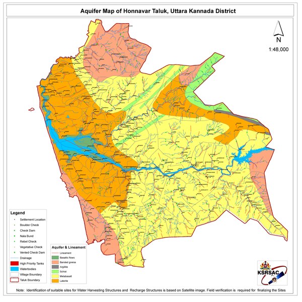
| DescriptionAquifer Map of Honnavar Taluk.pdf |
English: Water body Map of Honnavar Taluk |
| Date | |
| Source | https://kgis.ksrsac.in/kgisdocuments/TankRSPDF/Uttara%20Kannada/05487.pdf |
| Author | Department of Personnel and Administrative Reforms (e-Governance), Government of Karnataka |
| Camera location | 14° 17′ 05.31″ N, 74° 26′ 48.94″ E | View this and other nearby images on: OpenStreetMap |
|---|
Licensing

|
This file is a copyrighted work of the Government of India, licensed under the Government Open Data License - India (GODL).
Information on Related Items:
https://data.gov.in/sites/default/files/Gazette_Notification_OGDL.pdf GODL-India Government Open Data License – India true true |
 |
|
Deutsch ∙ English ∙ español ∙ français ∙ हिन्दी ∙ 日本語 ∙ മലയാളം ∙ मराठी ∙ русский ∙ 中文(简体) ∙ 中文(繁體) ∙ 中文(臺灣) ∙ +/− |

|
This image, which was originally posted in the source indicated above, has not yet been reviewed by an administrator or reviewer to confirm that the above license is valid. See Category:Unreviewed photos of GODL-India for further instructions.
|
Captions
Add a one-line explanation of what this file represents
Items portrayed in this file
depicts
14°17'5.309"N, 74°26'48.941"E
1 January 2021
application/pdf
aca9b6b11f9aeb17029f0a1a2b1462de1c728d97
2,253,811 byte
5,400 pixel
5,400 pixel
File history
Click on a date/time to view the file as it appeared at that time.
| Date/Time | Thumbnail | Dimensions | User | Comment | |
|---|---|---|---|---|---|
| current | 17:55, 15 October 2021 |  | 5,400 × 5,400 (2.15 MB) | Vijethnbharadwaj | Uploaded a work by Department of Personnel and Administrative Reforms (e-Governance), Government of Karnataka from https://kgis.ksrsac.in/kgisdocuments/TankRSPDF/Uttara%20Kannada/05487.pdf with UploadWizard |
File usage
The following pages on the English Wikipedia use this file (pages on other projects are not listed):
Metadata
This file contains additional information, probably added from the digital camera or scanner used to create or digitize it.
If the file has been modified from its original state, some details may not fully reflect the modified file.
| Software used | Esri ArcMap 10.1.0.3035 |
|---|---|
| Encrypted | no |
| Page size | 2592 x 2592 pts |
| Version of PDF format | 1.6 |
Retrieved from "https://en.wikipedia.org/wiki/File:Aquifer_Map_of_Honnavar_Taluk.pdf"