File:Antarctica_6400px_from_Blue_Marble.jpg
From Wikipedia, the free encyclopedia
Original file (6,400 × 6,400 pixels, file size: 3.31 MB, MIME type: image/jpeg)
| This is a file from the Wikimedia Commons. Information from its description page there is shown below. Commons is a freely licensed media file repository. You can help. |
| This is a featured picture, which means that members of the community have identified it as one of the finest images on the English Wikipedia, adding significantly to its accompanying article. If you have a different image of similar quality, be sure to upload it using the proper free license tag, add it to a relevant article, and nominate it. |
| This image was selected as picture of the day on the English Wikipedia for September 21, 2004, December 30, 2004, and September 23, 2005. |
Summary
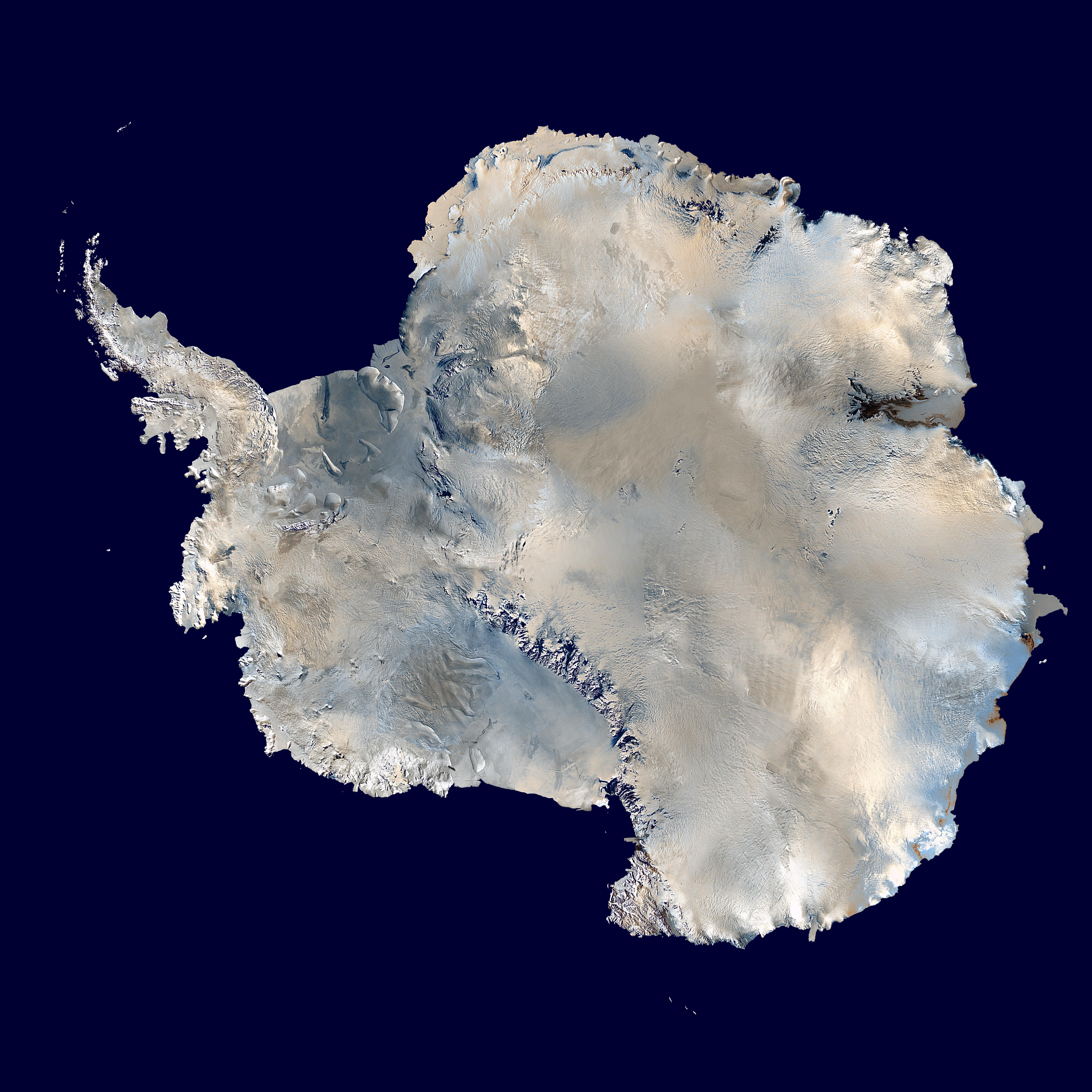
| DescriptionAntarctica 6400px from Blue Marble.jpg |
العربية: القارَّة القُطبيَّة الجنوبيَّة (أنتاركتيكا). صورة ساتليَّة تابعة لِوكالة ناسا، من ضمن بيانات الگُلَّة الزرقاء المُرسلة عبر الأقمار الاصطناعيَّة (من على بُعد كيلومترٍ واحد من العدسة الساتليَّة المُستخدمة). "تمَّ مزج بينات "MODIS" المُخصصة لِدراسة حالة الجليد القطبي مع تلك الخاصَّة بالإدارة القوميَّة لِدراسة المُحيطات والمُناخ—التي تمَّ الحصول عليها عبر الراديومتر الأكثر تطوُّرًا." تمَّ توليد الصورة باستخدام برنامج C مُخصص للتعامل مع صور وبيانات الگُلَّة الزرقاء، كما تمَّ الحصول على مُعادلات الإسقاط الشاقولي من موقع عالم الرِّياضيَّات.
مُلاحظة: تمَّ تعديل هذه الصورة يدويًّا في سبيل ملء بعض المناطق ذات العُنصورات (الپكسلات) السوداء، في الرُبعيَّة العُليا اليُمنى. يُعتقد بأنَّ تلك العُنصورات السوداء ظهرت نتيجة فُقدان بعض البيانات الخاصَّة بغطاء الأرض \ البحر المُستعملة في صناعة صورة الگُلَّة الزرقاء الأصليَّة. English: Antarctica. An orthographic projection of NASA's Blue Marble data set (1 km resolution global satellite composite). "MODIS observations of polar sea ice were combined with observations of Antarctica made by the National Oceanic and Atmospheric Administration’s AVHRR sensor—the Advanced Very High Resolution Radiometer." Image was generated using a custom C program for handling the Blue Marble files, with orthographic projection formulas from MathWorld.
Note: this image has been manually modified to fill in an area of black pixels in the ocean, in the upper right quadrant. The black pixels are presumed to be due to missing data in the land/sea mask used in making the original Blue Marble image. Español: El continente antártico. La imagen es una proyección ortogonal creada a partir del conjunto de datos satelitales Blue Marble de la NASA con una resolución de un kilómetro.
Français : Le continent Antarctique. L’image est construite en projection orthographique à partir des données satellites « Blue Marble » de la NASA, ayant une résolution d’un kilomètre. Les images de la banquise, prises par MODIS, ont été combinées avec celles du radiomètre avancé à très haute résolution de la National Oceanic and Atmospheric Administration pour former celle-ci. Elle a été générée en utilisant le logiciel MathWorld.
Note : cette image a été modifiée manuellement pour remplir une zone de pixels noir dans l’océan, dans le coin en haut à droite. Ces pixels manquants sont supposés être dus à des données manquantes dans le masque terre-mer utilisé pour construire l'image original de Blue Marble. Napulitano: Antartide, vista d’ ’o cielo.
Polski: Antarktyda. Odwzorowanie prostokątne opublikowanego w 2002 roku przez NASA zestawu danych Blue Marble.
مصرى: انتاركتيكا
فارسی: جنوبگان
Українська: Антарктида в ортографічній проекції з роздільною здатністю 1 км, на основі даних супутника MODIS. |
|||
| Date | ||||
| Source | Own work using: 2002 Blue Marble data @ http://visibleearth.nasa.gov/view_rec.php?id=2433 | |||
| Author | Dave Pape | |||
| Permission (Reusing this file) |
|
|||
| Other versions | Derivative works of this file: Antarctic Peninsula satellite image.jpgImage:Antarctica satellite globe.jpg |
Assessment
|

This image was selected as picture of the day on Wikimedia Commons for 5 October 2014. It was captioned as follows: Other languages:
Čeština: Antarktida v ortografické projekci ze souboru dat a fotografií NASA - NASA's Blue Marble data set. Français : Le continent Antarctique, image construite en projection orthographique à partir des données satellites « Blue Marble » de la NASA. Italiano: Proiezione ortogonale dell'Antartide della serie Blue Marble Next Generation della NASA, scattate con strumenti MODIS. Magyar: A NASA MODIS (Moderate-resolution Imaging Spectroradiometer) műszerével készült műholdkép az Antarktisz földrajzi zónában elhelyezkedő Antarktika kontinensről Polski: Antarktyda. Odwzorowanie prostokątne opublikowanego w 2002 roku przez NASA zestawu danych Blue Marble. Русский: Спутниковая фотография Антарктиды. |
| Annotations InfoField | This image is annotated: View the annotations at Commons |
Captions
Items portrayed in this file
depicts
5 October 2006
image/jpeg
affebbaf9a08867a4e4b5329ed0d4959fc866806
3,472,802 byte
6,400 pixel
6,400 pixel
File history
Click on a date/time to view the file as it appeared at that time.
| Date/Time | Thumbnail | Dimensions | User | Comment | |
|---|---|---|---|---|---|
| current | 14:21, 5 October 2006 | | 6,400 × 6,400 (3.31 MB) | Davepape | touched up part with missing data |
| 07:49, 5 October 2006 |  | 6,400 × 6,400 (3.31 MB) | Davepape | {{Information |Description=Antarctica. An orthographic projection of NASA's Blue Marble data set (1 km resolution global satellite composite). "MODIS observations of polar sea ice were combined with observations of Antarctica made by th |
File usage
- Antarctic
- Antarctic Treaty System
- Antarctic Treaty issue
- Antarctica
- CryoSat-2
- Geography of Antarctica
- Ice sheet
- List of Russian explorers
- Ocean fisheries
- Polar ice cap
- Scotia Bay
- South Pole
- User:2041foundation
- User:Axezz
- User:Axezz/Miscellaneous
- User:Cyde/Featured pictures
- User:Fixa123/sandbox
- User:Haunted by a ghoti/Antarctic sandbox
- User:Lingo nerd/TWA/Earth/2
- User:Noisalt/MainPageProposal
- User:Noisalt/TFAblurb
- User:Raul654/blurb1
- User:Raul654/test1
- User:Richrowe
- User:Sydneyws/TWA/Earth/2
- User:Yemlee/TWA/Earth/2
- User talk:Adrignola/Archive 1
- User talk:Phoenix B 1of3/Archive 3
- Wikipedia:Featured picture candidates/Image:Antarctica satellite globe.jpg delist
- Wikipedia:Featured picture candidates/September-2004
- Wikipedia:Featured picture candidates/delist/2006
- Wikipedia:Featured picture candidates/delist/2010
- Wikipedia:Featured picture candidates/delist/North America
- Wikipedia:Featured pictures/Space/Looking back
- Wikipedia:Featured pictures thumbs/01
- Wikipedia:POTD/December 30, 2004
- Wikipedia:POTD/September 23, 2005
- Wikipedia:Picture of the day/December 2004
- Wikipedia:Picture of the day/December 30, 2004
- Wikipedia:Picture of the day/September 2005
- Wikipedia:Picture of the day/September 23, 2005
- Template:Geography of Antarctica
- Category talk:Geography
- Portal:Chile/Selected article
- Portal:Chile/Selected article/1
- Portal:Earth sciences
- Portal:Earth sciences/Selected pictures
- Portal:Geography/Featured article
- Portal:Geography/Featured article/4
- Portal:Geography/Featured article/May, 2006
- Portal:Geography/Featured article/archive/2006
- Portal:Maps/Selected picture
- Portal:Maps/Selected picture/10
Global file usage
The following other wikis use this file:
- Usage on ace.wikipedia.org
- Usage on ady.wikipedia.org
- Usage on af.wikipedia.org
- Usage on als.wikipedia.org
- Usage on ang.wikipedia.org
- Usage on anp.wikipedia.org
- Usage on ar.wikipedia.org
- القارة القطبية الجنوبية
- قائمة الصحاري حسب المساحة
- مستخدم:Almountasir
- بوابة:القارة القطبية الجنوبية/مشاريع ويكي
- مستخدم:لينيوس العربي
- مستخدم:عمرو/ميسرة
- مستخدم:Ahmad jbr
- مستخدم:عمرو/كاملة
- ويكيبيديا:ترشيحات الصور المختارة/صورة بالقمر الصناعي للقارة القطبية الجنوبية
- مستخدم:ديفيد/صور ساهمت في جعلها مختارة
- مستخدم:محمد نصار 1
- مستخدم:الحسن55
- ويكيبيديا:صور مختارة/الفضاء والكون/نظرة إلى الخلف
- ويكيبيديا:صورة اليوم المختارة/أكتوبر 2015
- قالب:صورة اليوم المختارة/2015-10-08
- صفيحة القارة القطبية الجنوبية الجليدية
- ويكيبيديا:صورة اليوم المختارة/يناير 2017
- قالب:صورة اليوم المختارة/2017-01-01
- مستخدم:صندوق مستخدم/مستخدم مشروع ويكي أنتاركتيكا
- ويكيبيديا:صورة اليوم المختارة/أكتوبر 2018
- قالب:صورة اليوم المختارة/2018-10-31
- ويكيبيديا:صورة اليوم المختارة/أبريل 2020
- قالب:صورة اليوم المختارة/2020-04-22
- ويكيبيديا:صورة اليوم المختارة/مارس 2023
- قالب:صورة اليوم المختارة/2023-03-03
- برنامج نيوزيلندا لأبحاث القطب الجنوبي
- Usage on arz.wikipedia.org
- Usage on ast.wikipedia.org
- Usage on as.wikipedia.org
View more global usage of this file.
Metadata
This file contains additional information, probably added from the digital camera or scanner used to create or digitize it.
If the file has been modified from its original state, some details may not fully reflect the modified file.
| _error | 0 |
|---|