File:Al'Idrisi's_World_Map.jpg
From Wikipedia, the free encyclopedia
Size of this preview: 800 × 600 pixels. Other resolutions: 320 × 240 pixels | 640 × 480 pixels | 1,024 × 768 pixels | 1,280 × 960 pixels | 2,560 × 1,920 pixels | 4,160 × 3,120 pixels.
Original file (4,160 × 3,120 pixels, file size: 4.07 MB, MIME type: image/jpeg)
| This is a file from the Wikimedia Commons. Information from its description page there is shown below. Commons is a freely licensed media file repository. You can help. |
Summary
| DescriptionAl'Idrisi's World Map.jpg |
Sicilianu: Mappa dû munnu di Muhammad al-Idrisi (1154). Riproduzzioni dû planisferiu ntagghiatu su na lastra d'argentu pi lu Re Ruggeru II di Sicilia. In mostra ô Museu dâ Civiltà Islamica di Sharjah (EAU).
Polski: Mapa świata Muhammada al-Idrisiego (1154). Reprodukcja planisfery wygrawerowanej na srebrnej płycie dla króla Sycylii Rogera II. Na wystawie w Muzeum Cywilizacji Islamskiej w Szardży (ZEA).
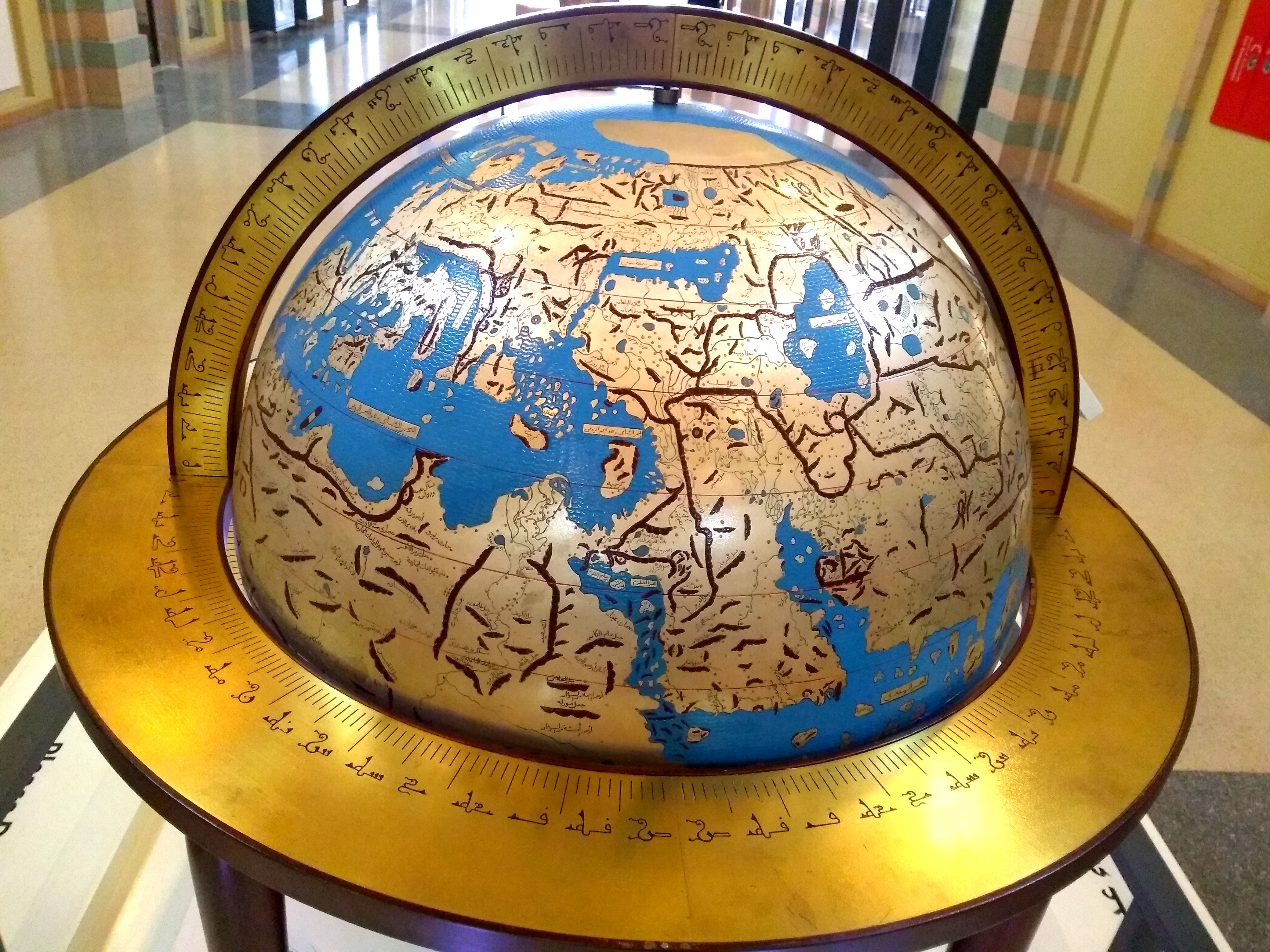
English: World map by Muhammad al-Idrisi (1154). Reproduction of the planisphere engraved on a silver plate for King Roger II of Sicily. On display at the Sharjah Museum of Islamic Civilization (UAE).
Italiano: Mappa del mondo di Muhammad al-Idrisi (1154). Riproduzione del planisferio inciso su una lastra d'argento per il re Roger II di Sicilia. In mostra al Museo della Civiltà Islamica di Sharjah (EAU). |
| Date | |
| Source | Own work |
| Author | S N Barid |
| Camera location | 25° 21′ 52.27″ N, 55° 23′ 19.85″ E | View this and other nearby images on: OpenStreetMap |
|---|
Licensing
I, the copyright holder of this work, hereby publish it under the following license:
This file is licensed under the Creative Commons Attribution-Share Alike 4.0 International license.
- You are free:
- to share – to copy, distribute and transmit the work
- to remix – to adapt the work
- Under the following conditions:
- attribution – You must give appropriate credit, provide a link to the license, and indicate if changes were made. You may do so in any reasonable manner, but not in any way that suggests the licensor endorses you or your use.
- share alike – If you remix, transform, or build upon the material, you must distribute your contributions under the same or compatible license as the original.
Captions
World map by Muhammad al-Idrisi (1154). Reproduction of the planisphere engraved on a silver plate for King Roger II of Sicily. On display at the Sharjah Museum of Islamic Civilization (UAE).
Mappa dû munnu di Muhammad al-Idrisi (1154). Riproduzzioni dû planisferiu ntagghiatu su na lastra d'argentu pi lu Re Ruggeru di Sicilia. In mostra ô Museu dâ Civiltà Islamica di Sharjah (EAU).
Mappa del mondo di Muhammad al-Idrisi (1154). Riproduzione del planisferio inciso su una lastra d'argento per il re Roger II di Sicilia. In mostra al Museo della Civiltà Islamica di Sharjah (EAU).
Mapa świata Muhammada al-Idrisiego (1154). Reprodukcja planisfery wygrawerowanej na srebrnej płycie dla króla Sycylii Rogera II. Na wystawie w Muzeum Cywilizacji Islamskiej w Szardży (ZEA).
Items portrayed in this file
depicts
12 September 2018
25°21'52.272"N, 55°23'19.846"E
0.05 second
3.59 millimetre
943
image/jpeg
96e8dc1bd7a02a8330411aa0cda3ac18f0635e9d
4,263,652 byte
3,120 pixel
4,160 pixel
File history
Click on a date/time to view the file as it appeared at that time.
| Date/Time | Thumbnail | Dimensions | User | Comment | |
|---|---|---|---|---|---|
| current | 10:31, 18 September 2018 | | 4,160 × 3,120 (4.07 MB) | S N Barid | User created page with UploadWizard |
File usage
The following pages on the English Wikipedia use this file (pages on other projects are not listed):
Global file usage
The following other wikis use this file:
- Usage on ary.wikipedia.org
- Usage on fa.wikipedia.org
- Usage on fr.wikipedia.org
- Usage on gl.wikipedia.org
- Usage on it.wikipedia.org
- Usage on mt.wikipedia.org
- Usage on scn.wikipedia.org
- Usage on uk.wikipedia.org
Metadata
This file contains additional information, probably added from the digital camera or scanner used to create or digitize it.
If the file has been modified from its original state, some details may not fully reflect the modified file.
| Camera manufacturer | motorola |
|---|---|
| Camera model | Moto G (5S) Plus |
| Author | Picasa |
| Exposure time | 1/20 sec (0.05) |
| F-number | f/2 |
| ISO speed rating | 943 |
| Date and time of data generation | 13:35, 12 September 2018 |
| Lens focal length | 3.59 mm |
| Latitude | 25° 21′ 52.27″ N |
| Longitude | 55° 23′ 19.85″ E |
| Altitude | 42 meters below sea level |
| Horizontal resolution | 72 dpi |
| Vertical resolution | 72 dpi |
| Software used | sanders_n-user 7.1.1 NPSS26.116-61-11 18 release-keys |
| File change date and time | 15:46, 18 September 2018 |
| Y and C positioning | Centered |
| Exposure Program | Normal program |
| Exif version | 2.2 |
| Date and time of digitizing | 13:35, 12 September 2018 |
| Meaning of each component |
|
| Shutter speed | 4.321 |
| APEX aperture | 2 |
| APEX brightness | 0 |
| Exposure bias | 0 |
| Maximum land aperture | 2 APEX (f/2) |
| Metering mode | Center weighted average |
| Flash | Flash did not fire, compulsory flash suppression |
| DateTime subseconds | 989526 |
| DateTimeOriginal subseconds | 989526 |
| DateTimeDigitized subseconds | 989526 |
| Supported Flashpix version | 1 |
| Color space | sRGB |
| Scene type | 0 |
| Custom image processing | Normal process |
| Exposure mode | Auto exposure |
| White balance | Auto white balance |
| Digital zoom ratio | 1 |
| Scene capture type | Standard |
| Unique image ID | 05d59befaab5fe69e02d29431c4d4523 |
| GPS time (atomic clock) | 09:35 |
| Geodetic survey data used | WGS-84 |
| GPS date | 12 September 2018 |
| GPS tag version | 2.2.0.0 |
| IIM version | 4 |
Retrieved from "https://en.wikipedia.org/wiki/File:Al%27Idrisi%27s_World_Map.jpg"