
Ennigerloh
Town in North Rhine-Westphalia, Germany / From Wikipedia, the free encyclopedia
Dear Wikiwand AI, let's keep it short by simply answering these key questions:
Can you list the top facts and stats about Ennigerloh?
Summarize this article for a 10 year old
SHOW ALL QUESTIONS
Ennigerloh (German pronunciation: [ˈɛnɪɡɐˌloː] ⓘ) is a town in the district of Warendorf, in North Rhine-Westphalia, Germany. It is situated approximately 25 km northeast of Hamm and 30 km southeast of Münster.
Quick Facts Country, State ...
Ennigerloh | |
|---|---|
 Marktplatz and Town Hall. | |
 Coat of arms | |
Location of Ennigerloh within Warendorf district 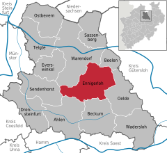 | |
 Ennigerloh  Ennigerloh | |
| Coordinates: 51°50′12″N 8°1′32″E | |
| Country | Germany |
| State | North Rhine-Westphalia |
| Admin. region | Münster |
| District | Warendorf |
| Subdivisions | 4 |
| Government | |
| • Mayor (2020–25) | Berthold Lülf[1] (SPD) |
| Area | |
| • Total | 125.15 km2 (48.32 sq mi) |
| Elevation | 104 m (341 ft) |
| Population (2022-12-31)[2] | |
| • Total | 19,757 |
| • Density | 160/km2 (410/sq mi) |
| Time zone | UTC+01:00 (CET) |
| • Summer (DST) | UTC+02:00 (CEST) |
| Postal codes | 59320 |
| Dialling codes | 02524 (Ennigerloh und Ostenfelde) 02528 (Enniger) 02587 (Westkirchen) |
| Vehicle registration | WAF |
| Website | www.ennigerloh.de |
Close
The town, located in an agricultural area and with a well-preserved medieval quarter, became more industrial in the 20th century as several cement factories were installed. Some of these closed towards the end of the century. Furniture manufacturing was also a significant industry.