
Castanheira de Pera
Municipality in Centro, Portugal / From Wikipedia, the free encyclopedia
Dear Wikiwand AI, let's keep it short by simply answering these key questions:
Can you list the top facts and stats about Castanheira de Pera?
Summarize this article for a 10 year old
SHOW ALL QUESTIONS
Castanheira de Pera (Portuguese pronunciation: [kɐʃtɐˈɲɐjɾɐ ðɨ ˈpeɾɐ] ⓘ), often erroneously written Castanheira de Pêra, is a municipality in the district of Leiria in Portugal. The population in 2011 was 3,191,[1] in an area of 66.77 km².[2]
Quick Facts Country, Region ...
Castanheira de Pera | |
|---|---|
_(cropped).jpg) | |
 Flag  Coat of arms | |
 | |
| Coordinates: 40°00′N 8°13′W | |
| Country | |
| Region | Centro |
| Intermunic. comm. | Região de Leiria |
| District | Leiria |
| Parishes | 1 |
| Government | |
| • President | Fernando José Pires Lopes (PS) |
| Area | |
| • Total | 66.77 km2 (25.78 sq mi) |
| Population (2011) | |
| • Total | 3,191 |
| • Density | 48/km2 (120/sq mi) |
| Time zone | UTC±00:00 (WET) |
| • Summer (DST) | UTC+01:00 (WEST) |
| Local holiday | July 4 |
| Website | http://www.cm-castanheiradepera.pt |
Close
The present Mayor is Fernando José Pires Lopes, elected by the Socialist Party. The municipal holiday is on July 4.
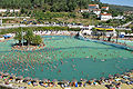 Roca's Beach
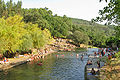 Corga
Corga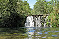 Véras
Véras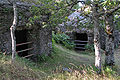 St. António da Neve


