
Berchtesgaden
Municipality in Bavaria, Germany / From Wikipedia, the free encyclopedia
Dear Wikiwand AI, let's keep it short by simply answering these key questions:
Can you list the top facts and stats about Berchtesgaden?
Summarize this article for a 10 year old
SHOW ALL QUESTIONS
Berchtesgaden (German pronunciation: [ˈbɛʁçtəsˌɡaːdn̩]) is a municipality in the district Berchtesgadener Land, Bavaria, in southeastern Germany, near the border with Austria, 30 km (19 mi) south of Salzburg and 180 km (110 mi) southeast of Munich. It lies in the Berchtesgaden Alps. South of the town, the Berchtesgaden National Park stretches along three parallel valleys.
Quick Facts Country, State ...
Berchtesgaden | |
|---|---|
 Berchtesgaden and the Watzmann in August 2010 | |
 Coat of arms | |
Location of Berchtesgaden within Berchtesgadener Land district 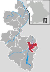 | |
 Berchtesgaden  Berchtesgaden | |
| Coordinates: 47°37′53″N 13°0′15″E | |
| Country | Germany |
| State | Bavaria |
| Admin. region | Oberbayern |
| District | Berchtesgadener Land |
| Government | |
| • Mayor (2020–26) | Franz Rasp[1] (CSU) |
| Area | |
| • Total | 34.78 km2 (13.43 sq mi) |
| Elevation | 700 m (2,300 ft) |
| Population (2022-12-31)[2] | |
| • Total | 7,623 |
| • Density | 220/km2 (570/sq mi) |
| Time zone | UTC+01:00 (CET) |
| • Summer (DST) | UTC+02:00 (CEST) |
| Postal codes | 83471 |
| Dialling codes | 08652 |
| Vehicle registration | BGL |
| Website | www |
Close
The Kehlstein mountain (1,835 m or 6,020 ft), with its Kehlsteinhaus (Eagle's Nest), is located in the area.