Αρχείο:Ragusa.png
From Wikipedia, the free encyclopedia
Δεν διατίθεται υψηλότερη ανάλυση.
Ragusa.png (675 × 354 εικονοστοιχεία, μέγεθος αρχείου: 128 KB, τύπος MIME: image/png)
|
|
Αυτό το αρχείο και η περιγραφή του προέρχονται από το Wikimedia Commons. Οι πληροφορίες από την σελίδα περιγραφής του εκεί εμφανίζονται παρακάτω. |
Σύνοψη
| ΠεριγραφήRagusa.png |
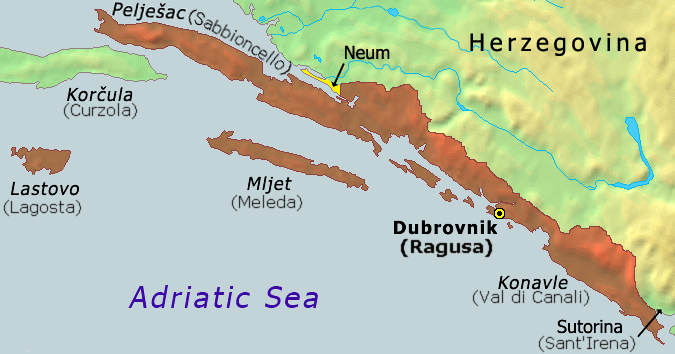
Hrvatski: Karta Dubrovačke republike iz 1808
English: Map of the Republic of Ragusa as of 1808 |
|||
| Ημερομηνία | ||||
| Πηγή | Demis Map Server (http://www2.demis.nl/mapserver/mapper.asp) data with additional annotations and modifications by self. | |||
| Δημιουργός | ChrisO | |||
| άλλες εκδόσεις |
Derivative works of this file: Ragusa-IT.png
|


|
This historical map image could be re-created using vector graphics as an SVG file. This has several advantages; see Commons:Media for cleanup for more information. If an SVG form of this image is available, please upload it and afterwards replace this template with
{{vector version available|new image name}}.
It is recommended to name the SVG file “Ragusa.svg”—then the template Vector version available (or Vva) does not need the new image name parameter. |
Λεζάντες
Δεν ορίστηκε λεζάντα
Map of the Republic of Ragusa as of 1808
Karte der Republik Ragusa ab 1808
Carte de la République de Raguse de 1808
Mappa della Repubblica di Ragusa dal 1808
Items portrayed in this file
απεικονίζει
28 Ιουλίου 2006
image/png
Ιστορικό αρχείου
Κλικάρετε σε μια ημερομηνία/ώρα για να δείτε το αρχείο όπως εμφανιζόταν εκείνη τη στιγμή.
| Ώρα/Ημερομ. | Μικρογραφία | Διαστάσεις | Χρήστης | Σχόλια | |
|---|---|---|---|---|---|
| τελευταία | 07:51, 21 Οκτωβρίου 2020 | | 675 × 354 (128 KB) | Claude Zygiel | Ragusan / Venetian names also (official until 1918) |
| 19:49, 6 Φεβρουαρίου 2020 |  | 675 × 354 (114 KB) | Ceha | Klek was part of Dubrovnik Republic. Tip of the peninsula is in Croatia, while the rest is in BiH. The same goes for the small island of Lastavica, which is today in Montenegro... https://www.google.com/maps/place/Mamula/@42.3952695,18.4181714,11z/data=!4m5!3m4!1s0x134c24e629d0b6ed:0x1d78b87fc20846b1!8m2!3d42.3954043!4d18.5585609 | |
| 21:15, 8 Σεπτεμβρίου 2010 |  | 675 × 354 (65 KB) | DIREKTOR | fix | |
| 17:02, 25 Νοεμβρίου 2006 |  | 675 × 354 (53 KB) | Tieum512 | {{Information |Description=Map of the Republic of Ragusa as of 1808 Based on Demis Web Map Server output |Source=http://en.wikipedia.org/wiki/Image:Ragusa.png |Date= |Author=User:ChrisO |Permission=GFDL |other_versions= }} |
Συνδέσεις αρχείου
Τα παρακάτω λήμματα συνδέουν σε αυτό το αρχείο:
Καθολική χρήση αρχείου
Τα ακόλουθα άλλα wiki χρησιμοποιούν αυτό το αρχείο:
- Χρήση σε an.wikipedia.org
- Χρήση σε ar.wikipedia.org
- Χρήση σε ast.wikipedia.org
- Χρήση σε azb.wikipedia.org
- Χρήση σε az.wikipedia.org
- Χρήση σε bar.wikipedia.org
- Χρήση σε be-tarask.wikipedia.org
- Χρήση σε be.wikipedia.org
- Χρήση σε bg.wikipedia.org
- Χρήση σε br.wikipedia.org
- Χρήση σε bs.wikipedia.org
- Χρήση σε ca.wikipedia.org
- Χρήση σε cs.wikipedia.org
- Χρήση σε da.wikipedia.org
- Χρήση σε de.wikipedia.org
- Χρήση σε en.wikipedia.org
- Χρήση σε eo.wikipedia.org
- Χρήση σε es.wikipedia.org
- Χρήση σε et.wikipedia.org
- Χρήση σε eu.wikipedia.org
- Χρήση σε fa.wikipedia.org
- Χρήση σε fi.wikipedia.org
- Χρήση σε fr.wikipedia.org
- Χρήση σε fy.wikipedia.org
- Χρήση σε gl.wikipedia.org
- Χρήση σε he.wikipedia.org
- Χρήση σε hu.wikipedia.org
- Χρήση σε ia.wikipedia.org
- Χρήση σε id.wikipedia.org
- Χρήση σε ie.wikipedia.org
- Χρήση σε it.wikipedia.org
- Χρήση σε ja.wikipedia.org
- Χρήση σε ko.wikipedia.org
- Χρήση σε li.wikipedia.org
- Χρήση σε mk.wikipedia.org
- Χρήση σε ms.wikipedia.org
- Χρήση σε mt.wikipedia.org
Δείτε περισσότερη καθολική χρήση αυτού του αρχείου.
Μεταδεδομένα
Αυτό το αρχείο περιέχει πρόσθετες πληροφορίες, πιθανόν από την ψηφιακή φωτογραφική μηχανή ή το scanner που χρησιμοποιήθηκε για την δημιουργία ή την ψηφιοποίησή της. Αν το αρχείο έχει τροποποιηθεί από την αρχική του κατάσταση, ορισμένες λεπτομέρειες πιθανόν να μην αντιστοιχούν πλήρως στην τροποποιημένη εικόνα.
| Οριζόντια ανάλυση | 28,35 dpc |
|---|---|
| Κατακόρυφη ανάλυση | 28,35 dpc |
Ανακτήθηκε από "https://el.wikipedia.org/wiki/Αρχείο:Ragusa.png"