پەڕگە:Mongols-map.png
From Wikipedia, the free encyclopedia
قەبارەی ئەم پێشبینینە: ٧٢٢ لە ٥٩٩ پیکسەڵ. ڕێزەلووشنەکانی تر: ٢٨٩ لە ٢٤٠ پیکسەڵ | ٥٧٨ لە ٤٨٠ پیکسەڵ | ٩٢٥ لە ٧٦٨ پیکسەڵ | ١٬٢٣٤ لە ١٬٠٢٤ پیکسەڵ | ١٬٨٠١ لە ١٬٤٩٥ پیکسەڵ.
پەڕگەی سەرەکی (١٬٨٠١ × ١٬٤٩٥ پیکسڵ، قەبارەی پەڕگە: ٢٫٧٩ مێگابایت، جۆری ئێم ئای ئێم ئی: image/png)
ئەم پەڕگە لە Wikimedia Commonsەوەیە و لەوانەیە لە پڕۆژەکانی دیکەش بەکار ھاتبێت. پێناسەکەی لەسەر پەڕەی وەسفی پەڕگەکە لە خوارەوە نیشان دراوە.
کورتە
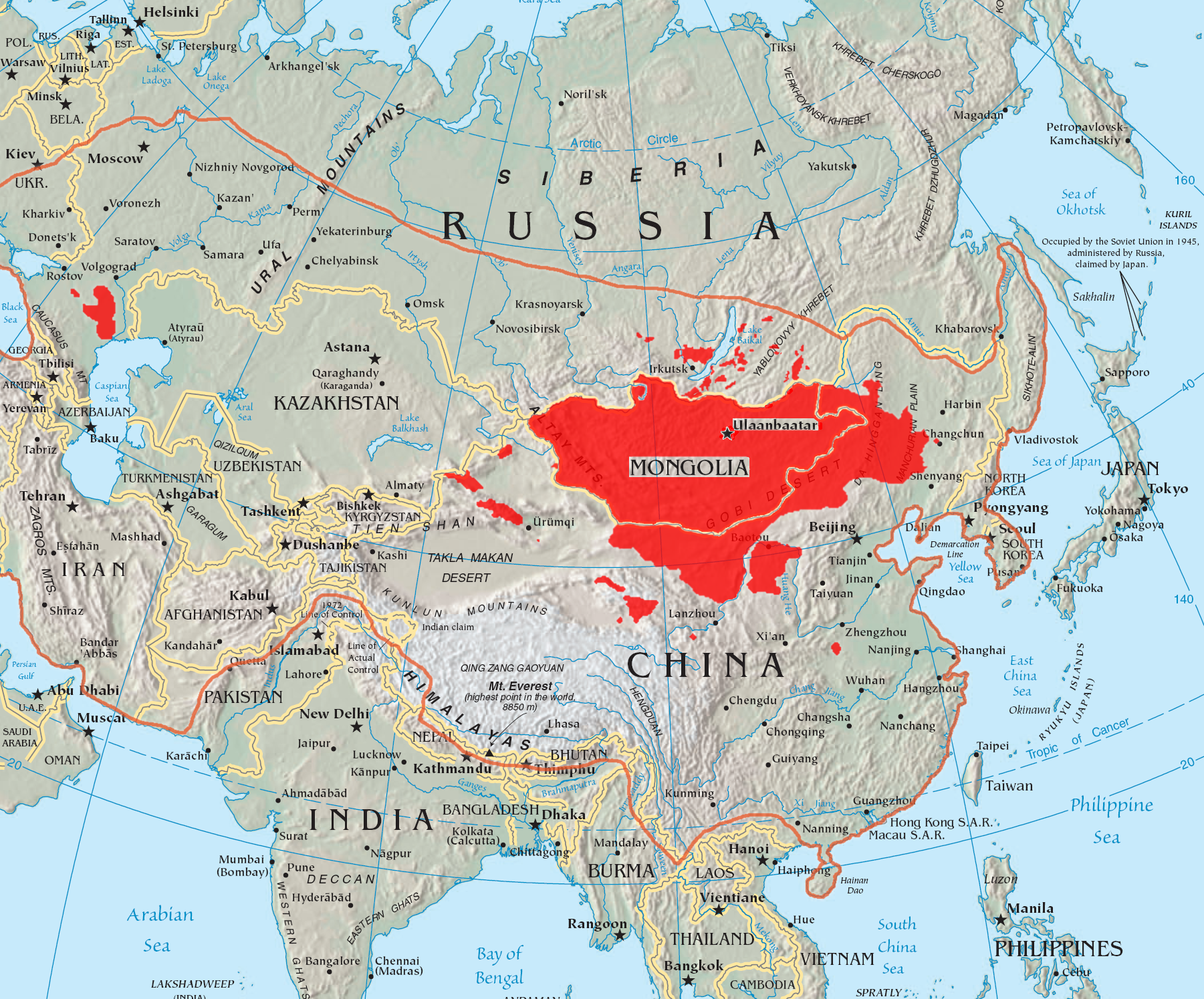
| وەسفMongols-map.png |
English: A map of the places that Mongol peoples live.
The orange line shows the extent of the Mongol Empire in the late 13th century. The red areas are the places dominated by ethnic Mongols. |
| ڕێکەوت | |
| سەرچاوە |
|
| بەرھەمھێنەر | Quadell |

|
This linguistic map image could be re-created using vector graphics as an SVG file. This has several advantages; see Commons:Media for cleanup for more information. If an SVG form of this image is available, please upload it and afterwards replace this template with
{{vector version available|new image name}}.
It is recommended to name the SVG file “Mongols-map.svg”—then the template Vector version available (or Vva) does not need the new image name parameter. |
مۆڵەتنامە
من، ھەڵگری مافی لەبەرگرتنەوەی ئەم بەرھەمە، لەژێر ئەم مۆڵەتنامەیانەدا بڵاوی دەکەمەوە:

|
ڕێگەدراوە بە لەبەرگرتنەوە، دابەشکردن ھەروەھا/یان سازاندنی ئەم بەڵگەنامەیە لەژێر مەرجی مۆڵەتی GNU بۆ بەڵگەنامەی ئازاد، وەشانی ١.٢ یان ھەر وەشانێکی تری دواتر کە بڵاوکراوەتەوە لەلایەن دامەزراوەی بەرنامەی ئازاد، بەبێ ھیچ بەشێکی جیاواز، بەبێ نووسین لەسەر بەرگی پێشەوە و دواوەی. وێنەیەک لەمۆڵەتەکە لە بەشێکدا ھەیە کە ناوی مۆڵەتی GNU بۆ بەڵگەنامەی ئازادە.http://www.gnu.org/copyleft/fdl.htmlGFDLGNU Free Documentation Licensetruetrue |
| ئەم پەڕگەیە لە ژێر مۆڵەتنامەی | ||
| ||
| This licensing tag was added to this file as part of the GFDL licensing update.http://creativecommons.org/licenses/by-sa/3.0/CC BY-SA 3.0Creative Commons Attribution-Share Alike 3.0truetrue |
This file is licensed under the Creative Commons Attribution-Share Alike 2.0 Generic license.
- تۆ ئازادی:
- بۆ بڵاکردنەوە – بۆ کۆپی کردن، دابەشکردن و دەستبەدەست ناردنی
- بۆ تێکەڵکردنەوە – بۆ سازاندنی کارەکە
- بەم مەرجانەی خوارەوە:
- دانەپاڵ – پێویستە باوەڕی گونجاو بدەیت، بەستەرێک بۆ مۆڵەتەکە دابین بکەیت و ئاماژە بەوە بکەیت کە ئایا گۆڕانکاری کراوە یان نا. دەتوانیت بە هەر شێوەیەکی گونجاو ئەوە بکەیت، بەڵام بە شێوەیەک نا کە وا دەربکەوێت کە مۆڵەتدەر پشتگیری تۆ یان بەکارهێنانەکەت بکات.
- بڵاوکردنەوەی گونجاو – ئەگەر لەسەر بنەمای ئەم کارە تێکەڵ، گۆڕان، یان ساز بکەی، پێویستە بەشدارییەکانت بە هەمان مۆڵەت یان هاوشێوەی مۆڵەتی ئەسڵی دابەش بکەی.
دەتوانی مۆڵەتنامەی دڵخوازت ھەڵبژێریت.
لێدوانەکان
Add a one-line explanation of what this file represents
Mapa przedstawia rozmieszczenie ludności mongolskiej
بەندەکانی لەم پەڕگەیەدا دەردەکەون
depicts ئینگلیزی
١٦ تەممووزی 2005
media type ئینگلیزی
image/png
مێژووی پەڕگە
کرتە بکە لەسەر یەکێک لە ڕێکەوت/کاتەکان بۆ بینینی پەڕگەکە بەو شێوەی لەو کاتەدا بووە.
| ڕێکەوت/کات | ھێما | ئەندازە | بەکارھێنەر | تێبینی | |
|---|---|---|---|---|---|
| هەنووکە | ١٤:٣٧، ٢٩ی ئایاری ٢٠٢٣ | | ١٬٨٠١ لە ١٬٤٩٥ (٢٫٧٩ مێگابایت) | Artanisen | High resolution map with the same borders and areas as version 17:34, 16 July 2005 (UTC) |
| ٢٠:١٣، ١٠ی نیسانی ٢٠٢١ |  | ٧٢٨ لە ٥٢٥ (٢٧٩ کیلۆبایت) | Fæ | Reverted to version as of 17:34, 16 July 2005 (UTC) Untrusted work of sockpuppets | |
| ٠٣:٣٥، ١٧ی کانوونی دووەمی ٢٠١٩ |  | ٧٢٨ لە ٥٢٥ (٢٩٥ کیلۆبایت) | Anchuhu | mongol | |
| ١٠:٥٦، ٢٢ی حوزەیرانی ٢٠١٧ |  | ٧٢٨ لە ٥٢٥ (٦٣٠ کیلۆبایت) | 일성강 | Reverted to version as of 12:47, 1 June 2017 (UTC) | |
| ٠٨:٥٤، ١٧ی حوزەیرانی ٢٠١٧ |  | ٧٢٨ لە ٥٢٥ (٢٧٩ کیلۆبایت) | Calthinus | Reverted to version as of 17:34, 16 July 2005 (UTC) | |
| ١٢:٤٧، ١ی حوزەیرانی ٢٠١٧ |  | ٧٢٨ لە ٥٢٥ (٦٣٠ کیلۆبایت) | 일성강 | fixed | |
| ١٧:٣٤، ١٦ی تەممووزی ٢٠٠٥ |  | ٧٢٨ لە ٥٢٥ (٢٧٩ کیلۆبایت) | Hottentot~commonswiki | This is a map of the places that Mongol peoples live. The information is based off of w:en:Image:Mongolsethnic.jpg, and the map I started with is w:en:Image:Asia-map.png. The orange line shows the extent of the Mongol Empire in the late 13th c | |
| ١٣:١٤، ١٦ی تەممووزی ٢٠٠٥ |  | ٧٢٨ لە ٥٢٥ (٢٩٧ کیلۆبایت) | Quadell | This is a map of the places that Mongol peoples live. The information is based off of [:w:en:Image:Mongolsethnic.jpg]], and the map I started with is w:en:Image:Asia-map.png. The orange line shows the extent of the Mongol Empire in the late 13th ce |
بەکارھێنانی پەڕگە
ئەم پەڕەی 2ە ئەم پەڕگەیە بەکار دەھێنێت:
بەکارھێنانی سەرانسەریی پەڕگە
ئەم ویکیانەی دیکەی خوارەوەش ئەم پەڕگە بەکاردێنن:
- بەکارھێنان لە af.wikipedia.org
- بەکارھێنان لە an.wikipedia.org
- بەکارھێنان لە ar.wikipedia.org
- بەکارھێنان لە arz.wikipedia.org
- بەکارھێنان لە ast.wikipedia.org
- بەکارھێنان لە azb.wikipedia.org
- بەکارھێنان لە ba.wikipedia.org
- بەکارھێنان لە be-tarask.wikipedia.org
- بەکارھێنان لە be.wikipedia.org
- بەکارھێنان لە bg.wiktionary.org
- بەکارھێنان لە bh.wikipedia.org
- بەکارھێنان لە br.wikipedia.org
- بەکارھێنان لە bs.wikipedia.org
- بەکارھێنان لە ca.wikipedia.org
- بەکارھێنان لە cs.wikipedia.org
- بەکارھێنان لە cv.wikipedia.org
- بەکارھێنان لە da.wikipedia.org
- بەکارھێنان لە diq.wikipedia.org
- بەکارھێنان لە dsb.wikipedia.org
- بەکارھێنان لە el.wikipedia.org
- بەکارھێنان لە en.wikipedia.org
بینینی بەکارھێنانی گشتی زیاتری ئەم پەڕگەیە.
دراوی مێتا
ئەم پەڕگە زانیاری زێدەی ھەیە، کە لەوە دەچێت کامێرا یان ھێماگر (scanner) خستبێتیە سەری. ئەگەر پەڕگەکە لە حاڵەتی سەرەتاییەکەیەوە دەستکاری کرابێ، شایەد بڕێ لە بڕگەکان بە تەواوی زانیارەکانی وێنە گۆڕدراوەکە نیشان نەدەن.
| شێوازی ئاسۆیی | ٧١ dpi |
|---|---|
| شێوازی ستوونی | ٧١ dpi |
| بۆشایی رهنگ | Uncalibrated |
| پانی وێنە | ١٬٨٠١ px |
| بەرزی وێنە | ١٬٤٩٥ px |
| نەرمەواڵەی بەکارهاتوو | Adobe Photoshop CC 2015 (Windows) |
| ڕێکەوت و کاتی بە دیجیتاڵی کردن | ١٧:١٧، ٢٩ی ئایاری ٢٠٢٣ |
| ڕێکەوتی و کاتی گۆڕانی پەڕگە | ١٨:٣٣، ٢٩ی ئایاری ٢٠٢٣ |
| Date metadata was last modified | ١٨:٣٣، ٢٩ی ئایاری ٢٠٢٣ |
| Unique ID of original document | xmp.did:ce56d03b-8dad-eb4e-a393-1b2d7714b062 |
وەرگیراو لە «https://ckb.wikipedia.org/wiki/پەڕگە:Mongols-map.png»