File:MountDutton.jpg
維基百科,自由的 encyclopedia
原始文件 (1,024 × 684像素,文件大小:151 KB,MIME类型:image/jpeg)
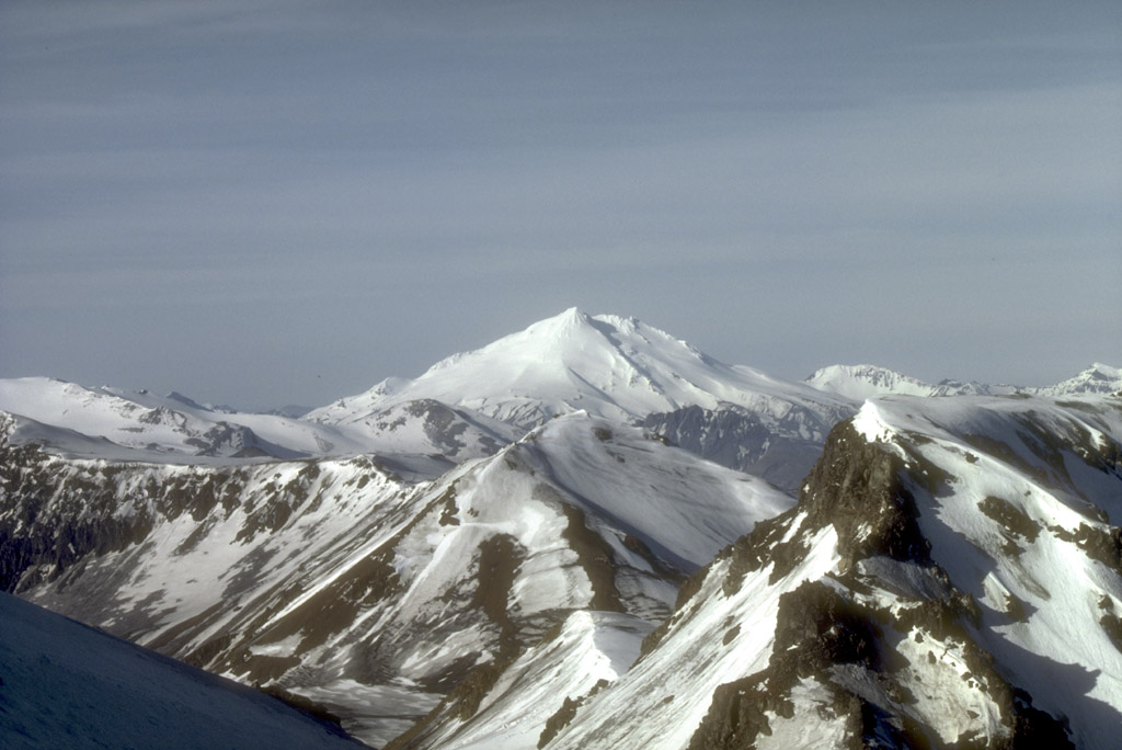
Mount Dutton, a 1,506-m (4,941 ft)-high stratovolcano, lies 14 km (9 mi) north of the community of King Cove on the Alaska Peninsula. The summit of Mount Dutton is composed of a cluster of lava domes. Mount Dutton has had no historical eruptions. However, seismic swarms beneath the volcano were recorded in 1984 to 1985 and again in 1989. View is to the southwest.
Photograph by M.E. Yount, U.S. Geological Survey, July, 1986.
Source: http://geopubs.wr.usgs.gov/dds/dds-40/
| Public domainPublic domainfalsefalse |
|
Bahasa Indonesia ∙ català ∙ čeština ∙ Deutsch ∙ eesti ∙ English ∙ español ∙ français ∙ galego ∙ italiano ∙ Nederlands ∙ português ∙ polski ∙ sicilianu ∙ suomi ∙ Tiếng Việt ∙ Türkçe ∙ български ∙ македонски ∙ русский ∙ മലയാളം ∙ 한국어 ∙ 日本語 ∙ 中文 ∙ 中文(简体) ∙ 中文(繁體) ∙ العربية ∙ فارسی ∙ +/− |
文件历史
点击某个日期/时间查看对应时刻的文件。
| 日期/时间 | 缩略图 | 大小 | 用户 | 备注 | |
|---|---|---|---|---|---|
| 当前 | 2005年1月27日 (四) 09:21 | | 1,024 × 684(151 KB) | GarciaB~commonswiki | Mount Dutton, Alaska |
文件用途
以下页面使用本文件:
全域文件用途
以下其他wiki使用此文件:
- arz.wikipedia.org上的用途
- ca.wikipedia.org上的用途
- ceb.wikipedia.org上的用途
- cs.wikipedia.org上的用途
- de.wikipedia.org上的用途
- en.wikipedia.org上的用途
- lld.wikipedia.org上的用途
- ms.wikipedia.org上的用途
- no.wikipedia.org上的用途
- ru.wikipedia.org上的用途
- ur.wikipedia.org上的用途
- www.wikidata.org上的用途
元数据
此文件中包含有扩展的信息。这些信息可能是由数码相机或扫描仪在创建或数字化过程中所添加。
如果此文件的源文件已经被修改,一些信息在修改后的文件中将不能完全反映出来。
| _error | 0 |
|---|