Ragiv:St._John_The_Evangelist,_Carterton_-_geograph.org.uk_-_1291769.jpg
From Wikipedia, the free encyclopedia
Gretot gudikum no pagebidon.
St._John_The_Evangelist,_Carterton_-_geograph.org.uk_-_1291769.jpg (640 × 480 pixel, ragivagret: 70 KB, pated MIME: image/jpeg)
Ragiv at kömon de Wikimedia Commons e kanon pagebön fa proyegs votik. Bepenot su pad bepenota ragiva onik pajonon dono.
Plän brefik
| BepenamSt. John The Evangelist, Carterton - geograph.org.uk - 1291769.jpg |
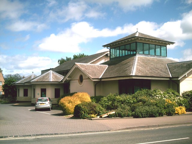
English: Part of St John The Evangelist's parish church, Burford Road, Carterton, Oxfordshire, seen from the west |
| Dät | |
| Fon | From geograph.org.uk |
| Lautan | Andrew Auger |
| Camera location | 51° 45′ 36″ N, 1° 35′ 42″ W | View this and other nearby images on: OpenStreetMap |
|---|
| Object location | 51° 45′ 36″ N, 1° 35′ 39″ W | View this and other nearby images on: OpenStreetMap |
|---|
Dälastad

|
This image was taken from the Geograph project collection. See this photograph's page on the Geograph website for the photographer's contact details. The copyright on this image is owned by Andrew Auger and is licensed for reuse under the Creative Commons Attribution-ShareAlike 2.0 license.
|
This file is licensed under the Creative Commons Attribution-Share Alike 2.0 Generic license.
Attribution: Andrew Auger
- Binol libik:
- to share – to copy, distribute and transmit the work
- to remix – to adapt the work
- Under the following conditions:
- attribution – You must give appropriate credit, provide a link to the license, and indicate if changes were made. You may do so in any reasonable manner, but not in any way that suggests the licensor endorses you or your use.
- share alike – If you remix, transform, or build upon the material, you must distribute your contributions under the same or compatible license as the original.
Captions
Add a one-line explanation of what this file represents
Items portrayed in this file
depicts Linglänapük
some value
copyright status Linglänapük
copyrighted Linglänapük
copyright license Linglänapük
source of file Linglänapük
file available on the internet Linglänapük
inception Linglänapük
6 mayul 2009
coordinates of the point of view Linglänapük
51°45'36.47"N, 1°35'41.64"W
coordinates of depicted place Linglänapük
51°45'36.14"N, 1°35'39.12"W
Jenotem ragiva
Välolös däti/timi ad logön ragivi soäsä äbinon ün tim at.
| Dät/Tim | Magodil | Mafots | Geban | Küpet | |
|---|---|---|---|---|---|
| anuik | 10:54, 2011 febul 27id | | 640 × 480 (70 KB) | GeographBot | == {{int:filedesc}} == {{Information |description={{en|1=St. John The Evangelist, Carterton An unusual design for a church}} |date=2009-05-06 |source=From [http://www.geograph.org.uk/photo/1291769 geograph.org.uk] |author=[http://www.geograph.org.uk/profi |
Yüms
Pads sököl payümons ko pad at:
Ragivigeb Valöpik
The following other wikis use this file:
- Geb su azb.wikipedia.org
- Geb su ceb.wikipedia.org
- Geb su cy.wikipedia.org
- Geb su en.wikipedia.org
- Geb su fa.wikipedia.org
- Geb su fr.wikipedia.org
- Geb su ga.wikipedia.org
- Geb su it.wikipedia.org
- Geb su lld.wikipedia.org
- Geb su ro.wikipedia.org
- Geb su www.wikidata.org
- Geb su zh-min-nan.wikipedia.org
Ragivanüns
Ragiv at keninükon nünis pluik, luveratiko se käm u numatüköm me kel päjafon. If ragiv at ya pevotükon e no plu leigon ko rigädastad okik, mögos, das pats anik is palisedöls no plu bepenons ragivi in stad anuik.
| _error | 0 |
|---|