Ficheiro:Utah_Territory_evolution_animation_-_August_2011.gif
De Wikipedia, a enciclopédia encyclopedia
Dimensões desta antevisão: 763 × 600 píxeis. Outras resoluções: 305 × 240 píxeis | 611 × 480 píxeis | 1 000 × 786 píxeis.
Imagem numa resolução maior (1 000 × 786 píxeis, tamanho: 158 kB, tipo MIME: image/gif, cíclico, 6 quadros, 15 s)
|
|
Esta imagem provém do Wikimedia Commons, um acervo de conteúdo livre da Wikimedia Foundation que pode ser utilizado por outros projetos.
|
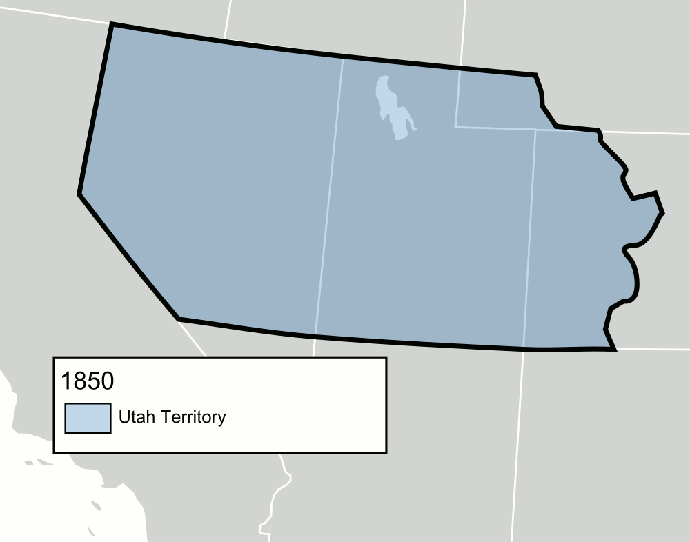
| DescriçãoUtah Territory evolution animation - August 2011.gif | An animated GIF of the Utah Territory as it evolved from 1850 to 1896, when statehood was granted. The territory's boundaries may not be exact. |
| Data | (UTC) |
| Origem | |
| Autor |
|
_-_Geographicus_-_UtahNewMexico-colton-1855.jpg)
Eu, titular dos direitos de autor desta obra, publico-a com as seguintes licenças:
| A utilização deste ficheiro é regulada nos termos da licença Creative Commons - Atribuição-CompartilhaIgual 3.0 Não Adaptada. | ||
| ||
| Esta marca de licenciamento foi adicionada a este ficheiro durante a atualização da licença GFDL.http://creativecommons.org/licenses/by-sa/3.0/CC BY-SA 3.0Creative Commons Attribution-Share Alike 3.0truetrue |

|
É concedida permissão para copiar, distribuir e/ou modificar este documento nos termos da Licença de Documentação Livre GNU, versão 1.2 ou qualquer versão posterior publicada pela Free Software Foundation; sem Secções Invariantes, sem textos de Capa e sem textos de Contra-Capa. É incluída uma cópia da licença na secção intitulada GNU Free Documentation License.http://www.gnu.org/copyleft/fdl.htmlGFDLGNU Free Documentation Licensetruetrue |
Pode escolher a licença que quiser.
Registo de carregamento original
This image is a derivative work of the following images:
- File:Blank_US_Map.svg licensed with Cc-by-sa-3.0-migrated, GFDL
- 2009-11-05T19:44:02Z NuclearVacuum 959x593 (91518 Bytes) minor fix from previous upload
- 2009-11-05T19:39:42Z NuclearVacuum 959x593 (88399 Bytes) Fixed up the borders so they are connected with each state and loosing that gap between them.
- 2008-10-09T16:36:40Z Howcheng 959x593 (80121 Bytes) Reverted to version as of 08:32, 14 June 2007
- 2008-03-12T00:20:02Z AMK1211 959x593 (174744 Bytes) Added borders: Light blue for water borders and black for land borders (international borders thicker).
- 2007-06-14T08:32:47Z Fibonacci 959x593 (80121 Bytes) Optimised code.
- 2006-07-12T23:00:30Z Theshibboleth 959x593 (90537 Bytes) The line framework around Alaska and Hawaii has been pushed a bit
- 2006-07-12T06:35:19Z Theshibboleth 959x593 (89828 Bytes) added DC
- 2006-07-12T06:05:05Z Theshibboleth 959x593 (89649 Bytes) {{Information |Description=A blank map of the United States in scalable vector form. |Source=Own work, based on [[:Image:Electorial map.svg]], inspired by [[:Image:BlankMap-World.png]] |Date=11 July 2006 |Author=[[User:Theshi
Legendas
Adicione uma explicação de uma linha do que este ficheiro representa
Elementos retratados neste ficheiro
retrata
15 agosto 2011
Histórico do ficheiro
Clique uma data e hora para ver o ficheiro tal como ele se encontrava nessa altura.
| Data e hora | Miniatura | Dimensões | Utilizador | Comentário | |
|---|---|---|---|---|---|
| atual | 18h12min de 8 de junho de 2013 | | 1 000 × 786 (158 kB) | Mangoman88 | Fixed the name of the Nebraska Territory on the 1861 slide |
| 01h16min de 18 de julho de 2012 |  | 1 000 × 786 (158 kB) | Mangoman88 | Fix border along the 37th parallel north | |
| 05h06min de 15 de agosto de 2011 |  | 500 × 393 (70 kB) | Mangoman88 | Fixing gif transparency | |
| 04h33min de 15 de agosto de 2011 |  | 500 × 393 (71 kB) | Mangoman88 | {{Information |Description=An animated {{w|Graphics Interchange Format|GIF}} of the {{w|Utah Territory}} as it evolved from 1850 to 1896, when statehood was granted. The territory's boundaries may not be exact. |Source=*[[:File:Blank_US_Map.svg|Blank_US_M |
Utilização local do ficheiro
A seguinte página usa este ficheiro:
Utilização global do ficheiro
As seguintes wikis usam este ficheiro:
- ca.wikipedia.org
- de.wikipedia.org
- en.wikipedia.org
- es.wikipedia.org
- fa.wikipedia.org
- he.wikipedia.org
- it.wikipedia.org
- nl.wikipedia.org
- no.wikipedia.org
- sv.wikipedia.org
- vi.wikipedia.org