Ficheiro:Nazi_Germany.png
De Wikipedia, a enciclopédia encyclopedia
Dimensões desta antevisão: 772 × 600 píxeis. Outras resoluções: 309 × 240 píxeis | 618 × 480 píxeis | 989 × 768 píxeis | 1 200 × 932 píxeis.
Imagem numa resolução maior (1 200 × 932 píxeis, tamanho: 263 kB, tipo MIME: image/png)
|
|
Esta imagem provém do Wikimedia Commons, um acervo de conteúdo livre da Wikimedia Foundation que pode ser utilizado por outros projetos.
|

|
File:Nazi Germany.svg é uma versão vetorial deste ficheiro. Ela deve ser usada em vez desta imagem em formato raster, se não for de qualidade inferior.
File:Nazi Germany.png → File:Nazi Germany.svg
Para mais informações, consulte Ajuda:SVG.
|
 |
Descrição do ficheiro
| DescriçãoNazi Germany.png |
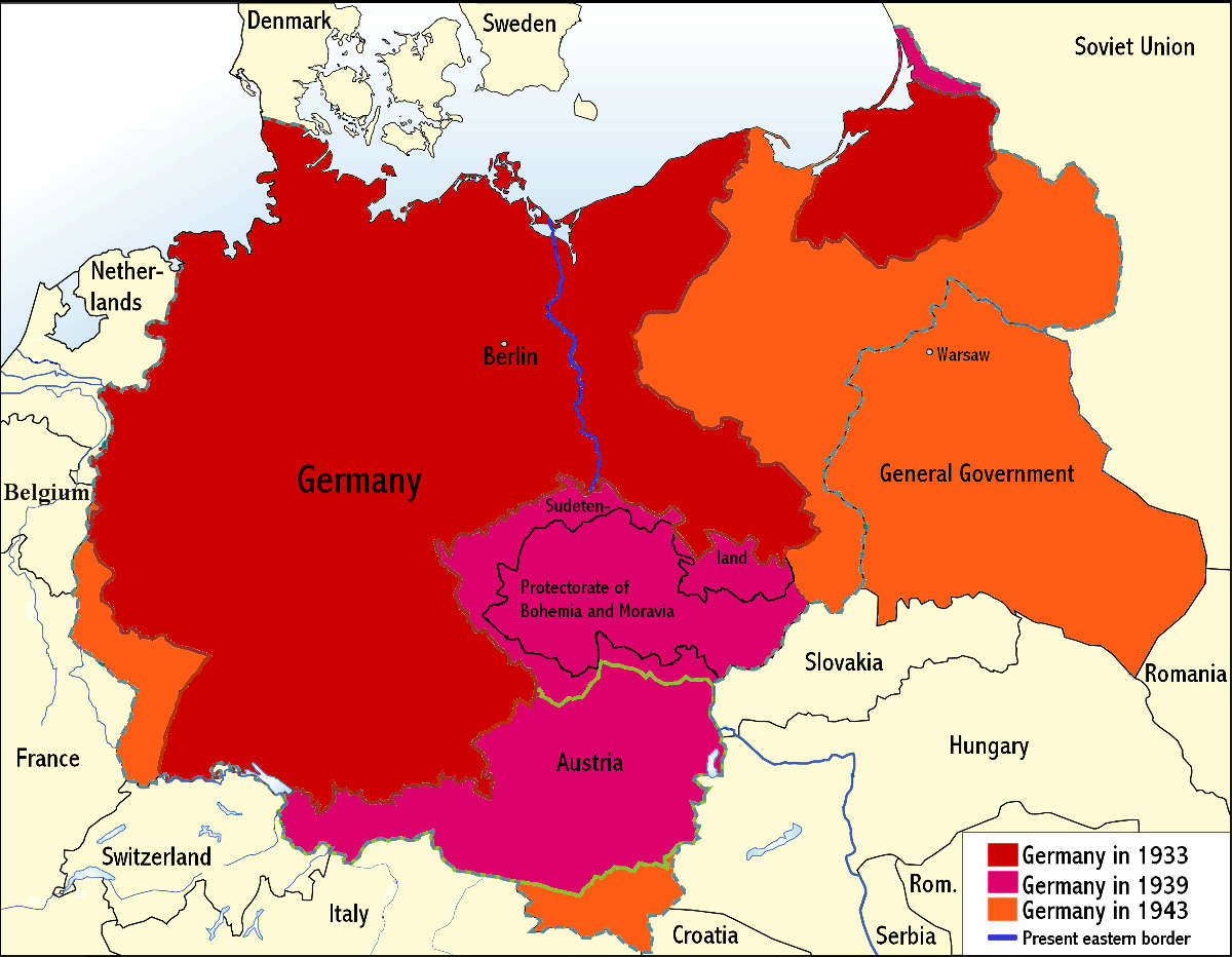
English: An overview map of Nazi Germany to 1943. |
||||||||
| Data | |||||||||
| Origem | Transferred from the English Wikipedia. Original file is/was here. (Original upload log available below.) | ||||||||
| Autor | Wikinist | ||||||||
| Permissão (Reutilizar este ficheiro) |
|
||||||||
| Outras versões |
Obras derivadas deste ficheiro: Nazi Germany-it.svg |


Registo de carregamento original
All the following user names refer to the English Wikipedia.
| Date/Time | Dimensions | User | Comment |
|---|---|---|---|
| 00:03, 24 June 2008 | 1,200×932 (275 KB) |
Wikinist | (Belgia -> Belgium) |
| 00:52, 30 April 2008 | 1,200×932 (286 KB) |
R-41 | (Removed swastika from map. The title "Germany" is moved up to the centre of Germany on the map now.) |
| 21:37, 29 April 2008 | 1,200×932 (291 KB) |
Wikinist | (== Description== {{Information |Description=An overview map of Nazi Germany, based on another map[http://en.wikipedia.org/wiki/Image:GDR.png] by [[:de:Benutzer:kgberger|kgberger]]. Placenames replaced with English ones, resolution decreased, a lot of info) |
Legendas
Adicione uma explicação de uma linha do que este ficheiro representa
Elementos retratados neste ficheiro
retrata
30 abril 2008
Histórico do ficheiro
Clique uma data e hora para ver o ficheiro tal como ele se encontrava nessa altura.
| Data e hora | Miniatura | Dimensões | Utilizador | Comentário | |
|---|---|---|---|---|---|
| atual | 23h35min de 6 de junho de 2009 | | 1 200 × 932 (263 kB) | MaggotMaster | Reverted to version as of 22:18, 21 May 2009 |
| 11h57min de 4 de junho de 2009 |  | 1 200 × 932 (234 kB) | Fz22~commonswiki | {{Information |Description= |Source= |Date= |Author= |Permission= |other_versions= }} | |
| 22h18min de 21 de maio de 2009 |  | 1 200 × 932 (263 kB) | Hohum | Reduced garish colour intensity. | |
| 09h30min de 19 de janeiro de 2009 |  | 1 200 × 932 (207 kB) | Brianski | clean up the legend | |
| 20h20min de 8 de outubro de 2008 |  | 1 200 × 932 (275 kB) | File Upload Bot (Magnus Manske) | {{BotMoveToCommons|en.wikipedia}} {{Information |Description={{en|An overview map of Nazi Germany, based on another map (en::Image:GDR.png) by kgberger. Placenames replaced with English ones, resolution decreased, a lot |
Utilização local do ficheiro
As seguintes 2 páginas usam este ficheiro:
Utilização global do ficheiro
As seguintes wikis usam este ficheiro:
- la.wikipedia.org