Attēls:Czechoslovakia.png
From Wikipedia, the free encyclopedia
Sākotnējais fails (1 188 × 604 pikseļi, faila izmērs: 69 KB, MIME tips: image/png)
| Šis fails ir no Vikikrātuves. Tā apraksts no attēla lapas Vikikrātuvē ir parādīts zemāk. Vikikrātuve ir brīvi licencēta failu krātuve. Tu vari tai palīdzēt. |

|
This historical map image could be re-created using vector graphics as an SVG file. This has several advantages; see Commons:Media for cleanup for more information. If an SVG form of this image is available, please upload it and afterwards replace this template with
{{vector version available|new image name}}.
It is recommended to name the SVG file “Czechoslovakia.svg”—then the template Vector version available (or Vva) does not need the new image name parameter. |
Kopsavilkums
| AprakstsCzechoslovakia.png |
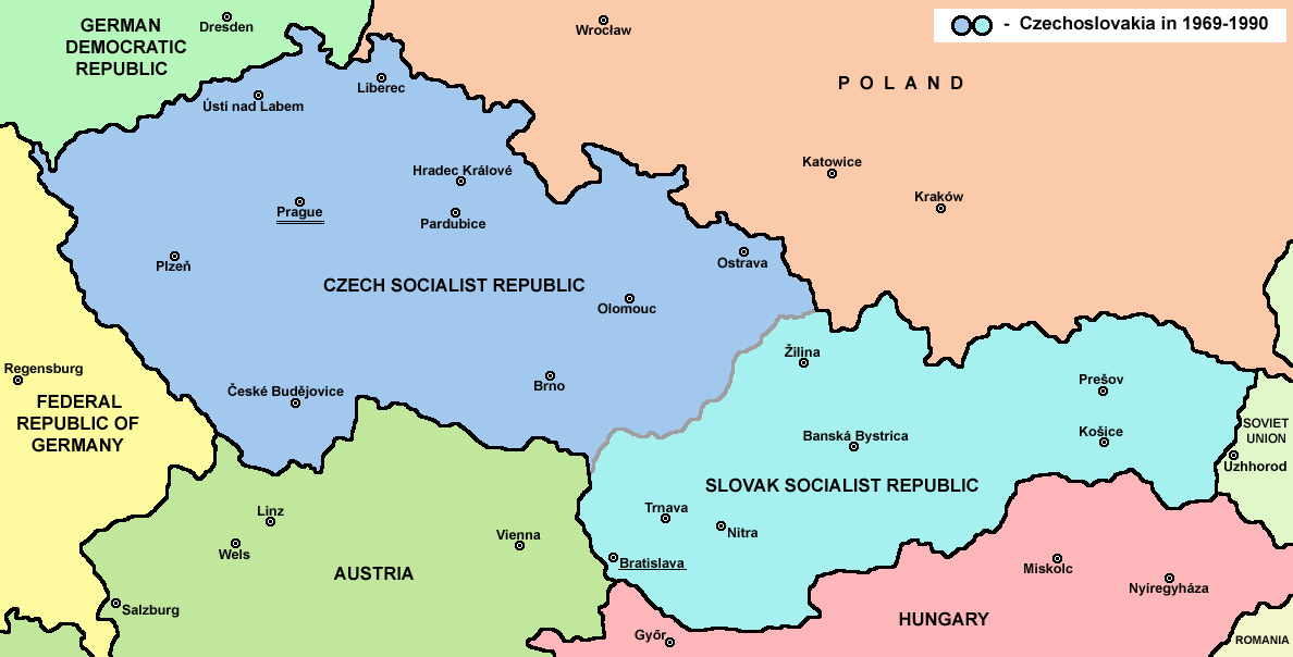
English: Map of Czechoslovakia in 1969-1990 |
||
| Avots | Paša darbs | ||
| Autors | PANONIAN | ||
| Citas versijas |
|


Licence
| Public domainPublic domainfalsefalse |
| |
This work has been released into the public domain by its author, PANONIAN, at the angļu Vikipēdija project. This applies worldwide. In case this is not legally possible: |
References
Main reference:
- Map is created according to this external source: http://www.tcnj.edu/~guhr2/images/czechoslovakia.jpg archive copy at the Wayback Machine
Secondary references with similar maps:
- http://1.bp.blogspot.com/_Qe1wgxDiEdU/TGti_qWpeYI/AAAAAAAABo0/sSqAfIpQMuU/s1600/1213M_CS.gif
- https://jspivey.wikispaces.com/file/view/T010895A.gif/34419939/T010895A.gif
- http://media.web.britannica.com/eb-media/84/105684-050-0D8412E3.gif archive copy at the Wayback Machine
- http://www.gatheringofisrael.com/atlas/europe/slavic/CS_prague.gif
- http://collections.lib.uwm.edu/agsmap/images/lg/DSCN1455.jpg[dead link]
- http://leccos.com/pics/pic/ceskoslovensko-_mapa_1950.jpg archive copy at the Wayback Machine
- http://www.math.sk/knor/GIF/mapa.gif
- http://ckpaji.sweb.cz/ceskoslovensko.jpg archive copy at the Wayback Machine
- http://www.power.szm.com/historia/mapa_TV_vysielacov_1978.jpg
Secondary references about Geo-political situation - published sources:
- The Times History of Europe, Times Books, London, 2002.
- Richard Overy, The Times History of the 20th Century, Times Books, London, 2004.
- The Times Atlas svjetske povijesti, Cankarjeva založba, Ljubljana - Zagreb, 1986.
- Istorijski atlas, Geokarta, Beograd, 1999.
- Školski istorijski atlas, Zavod za izdavanje udžbenika SR Srbije, Beograd, 1970.
- Povijesni atlas, Učila - Zagreb, Zagreb, 1971.
- Povijesni atlas za osnovnu školu, Kartografija - Tlos, Zagreb, 1975.
- Denis Šehić - Demir Šehić, Istorijski atlas sveta, Beograd, 2007.
Secondary reference about sizable cities:
|
|
This map image could be re-created using vector graphics as an SVG file. This has several advantages; see Commons:Media for cleanup for more information. If an SVG form of this image is available, please upload it and afterwards replace this template with
{{vector version available|new image name}}.
It is recommended to name the SVG file “Czechoslovakia.svg”—then the template Vector version available (or Vva) does not need the new image name parameter. |
The production, editing or release of this file was supported by the Community-Budget of Wikimedia Deutschland. To see other files made with the support of Wikimedia Deutschland, please see the category Supported by Wikimedia Deutschland. العربية ∙ বাংলা ∙ Deutsch ∙ English ∙ Esperanto ∙ français ∙ magyar ∙ Bahasa Indonesia ∙ italiano ∙ 日本語 ∙ македонски ∙ മലയാളം ∙ Bahasa Melayu ∙ Nederlands ∙ português ∙ русский ∙ slovenščina ∙ svenska ∙ українська ∙ தமிழ் ∙ +/−
|
Captions
Šajā failā attēlotais
attēlo
Šai īpašībai ir vērtība, bet tā ir nezināma
image/png
checksum angļu
988843af23cf6b2ab48cfc10bab00f4951a2c319
data size angļu
71 058 Baits
604 pikselis
1 188 pikselis
Faila hronoloģija
Uzklikšķini uz datums/laiks kolonnā esošās saites, lai apskatītos, kā šis fails izskatījās tad.
| Datums/Laiks | Attēls | Izmēri | Dalībnieks | Komentārs | |
|---|---|---|---|---|---|
| tagadējais | 2022. gada 12. jūlijs, plkst. 17.45 | | 1 188 × 604 (69 KB) | Sebastian Wallroth | CROPPED |
| 2017. gada 12. februāris, plkst. 20.38 |  | 1 221 × 652 (69 KB) | PANONIAN | Reverted to version as of 11:00, 24 April 2011 (UTC) - why you uploading polish version over english one? upload polish version under different filename | |
| 2017. gada 9. februāris, plkst. 18.18 |  | 1 221 × 652 (57 KB) | Kelvin | Reverted to version as of 15:13, 9 February 2017 (UTC) | |
| 2017. gada 9. februāris, plkst. 18.17 |  | 1 221 × 652 (69 KB) | Kelvin | Reverted to version as of 11:00, 24 April 2011 (UTC) | |
| 2017. gada 9. februāris, plkst. 18.13 |  | 1 221 × 652 (57 KB) | Kelvin | Polish names of countries /Polskie określenia krajów | |
| 2011. gada 24. aprīlis, plkst. 14.00 |  | 1 221 × 652 (69 KB) | PANONIAN | correction | |
| 2011. gada 23. aprīlis, plkst. 13.27 |  | 1 221 × 652 (69 KB) | PANONIAN | improved version | |
| 2006. gada 11. decembris, plkst. 02.31 |  | 1 200 × 624 (19 KB) | Severino666~commonswiki | Map of Czechoslovakia (self made) Category:Maps of Czechoslovakia Category:Maps of Czech history Category:Maps of the history of Slovakia Category:Maps of the history of Central Europe {{PD}} |
Faila lietojums
Šo failu izmanto šajās 2 lapās:
Globālais faila lietojums
Šīs Vikipēdijas izmanto šo failu:
- Izmantojums ang.wikipedia.org
- Izmantojums an.wikipedia.org
- Izmantojums ar.wikipedia.org
- Izmantojums azb.wikipedia.org
- Izmantojums az.wikipedia.org
- Izmantojums bar.wikipedia.org
- Izmantojums ba.wikipedia.org
- Izmantojums bcl.wikipedia.org
- Izmantojums be-tarask.wikipedia.org
- Izmantojums be.wikipedia.org
- Izmantojums bg.wikipedia.org
- Izmantojums bn.wikipedia.org
- Izmantojums br.wikipedia.org
- Izmantojums bs.wikipedia.org
- Izmantojums ca.wikipedia.org
- Izmantojums cv.wikipedia.org
- Izmantojums da.wikipedia.org
- Izmantojums de.wikipedia.org
- Izmantojums dsb.wikipedia.org
- Izmantojums el.wikipedia.org
- Izmantojums en.wikipedia.org
- Czechoslovakia
- History of Slovakia
- History of Czechoslovakia (1948–1989)
- History of Czechoslovakia (1989–1992)
- Economy of communist Czechoslovakia
- History of Czechoslovakia
- Dissolution of Czechoslovakia
- Czechoslovak Socialist Republic
- Portal:Slovakia
- She Grazed Horses on Concrete
- Rugby union in Czechoslovakia
Skatīt šī faila pilno globālo izmantojumu.
Metadati
Šis fails satur papildu informāciju, kuru, visticamāk, ir pievienojis digitālais fotoaparāts vai skeneris, ar ko veidots fails. Ja šis fails pēc tam ir ticis modificēts, šie dati var neatbilst izmaiņām (var būt novecojuši).
| Horizontālā izšķirtspēja | 28,35 dpc |
|---|---|
| Vertikālā izšķirtspēja | 28,35 dpc |